
ARCTIC: At the Cutting Edge of Climate Change
by Robert Glenn Ketchum

In 1993, I began traveling to the Arctic. I have been across The Northwest Passage by yacht; to the North Pole twice; to little-visited Russian islands; and aboard research vessels in Greenland, Labrador, Newfoundland, and Baffin Island, taking the opportunity to visit Iqualuit, the capital of Nunavut, the recently created Inuit nation and territories.

~Robert Glenn Ketchum
Wednesday, May 5, 2021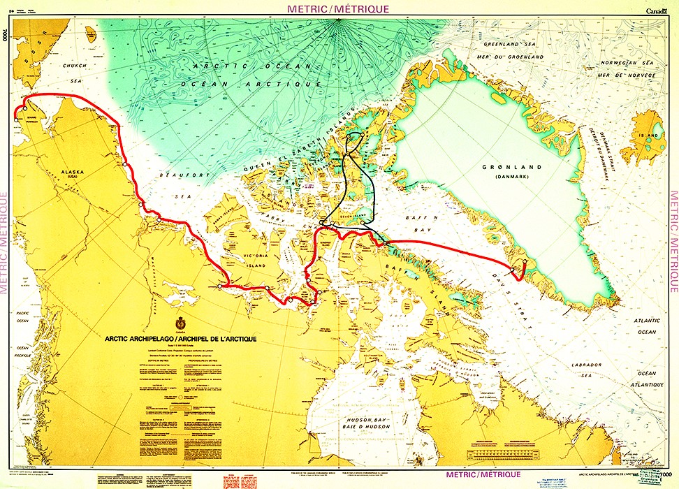
ARCTIC: At the Cutting Edge of Climate Change, #247
ARCTIC, #247:
This is the last post for this Northwest Passage blog. Appropriately, it is a map of our journey, compiled for us by Captain Jouning. As you will recall, our adventure began in Nome, AK, to the far left. Trying to avoid the pack ice, we hugged the coastline of the Alaskan North Slope and Canada, as we progressed. This blog recounts the many places, and villages, at which we stopped along the way. If you look carefully, you will see that shortly after our trip turns North, there are red dots. That marks the spot where “Itasca” became trapped in the ice of the James Ross Strait for several days. Once we freed ourselves, and turned East, we reached the coast of Baffin Island and dropped anchor at the town of Pond Inlet. It was here that Bill Simon commandeered a cargo plane and two pilots. who allowed us to join them for some flightseeing. Our plane visited some historic, locations, the town of Resolute, and then flew North to Eureka Base, where we spent the night. The next day we visited Otto Fjord, returned to Eureka to fuel up, and then headed back to Pond Inlet with an attempted stop at Grise Fjord that nearly killed all of us. It was a great privilege for me as a photographer to get to view this vast Arctic landscape, so I thank my shipmates for having me along, and I hope all of you think my photographs have done justice to a part of the world you might never see.
PINTEREST: pinterest.com/LittleBearProd
____________________________________________________
photograph(s) © copyright, ROBERT GLENN KETCHUM, 2021,
@RbtGlennKetchum @RobertGKetchum @LittleBearProd #LittleBearProd
Follow Robert Glenn Ketchum's Photographic Activism Online:
LINKEDIN: linkedin.com/in/RbtGlennKetchum
FACEBOOK: facebook.com/RobertGlennKetchum
FACEBOOK: facebook.com/NoPebbleMine.photos
TWITTER: twitter.com/RbtGlennKetchum
TWITTER: twitter.com/RobertGKetchum
SOCIAL MEDIA by #LittleBearProd: LittleBearProd
Wach Gallery: Wach Gallery
Wednesday, April 28, 2021
ARCTIC: At the Cutting Edge of Climate Change, #246
ARCTIC, #246:
When the villagers that live in this house saw me standing in the street making this picture, they came out and talked to me. I explained what I was doing, and they were fine with me photographing their home, so I asked what the smaller hut at the base of the stairs was, and the wife responded that it was her husband’s office, and that he had to walk to work everyday. Hahaha! Very tidy little property, with great views from the upper deck and windows of the home, and a dramatic red paint job that really makes the house pop out in the surrounding granite terrain.
PINTEREST: pinterest.com/LittleBearProd
____________________________________________________
photograph(s) © copyright, ROBERT GLENN KETCHUM, 2021,
@RbtGlennKetchum @RobertGKetchum @LittleBearProd #LittleBearProd
Follow Robert Glenn Ketchum's Photographic Activism Online:
LINKEDIN: linkedin.com/in/RbtGlennKetchum
FACEBOOK: facebook.com/RobertGlennKetchum
FACEBOOK: facebook.com/NoPebbleMine.photos
TWITTER: twitter.com/RbtGlennKetchum
TWITTER: twitter.com/RobertGKetchum
SOCIAL MEDIA by #LittleBearProd: LittleBearProd
Wach Gallery: Wach Gallery
Wednesday, April 21, 2021
ARCTIC: At the Cutting Edge of Climate Change, #245
ARCTIC, #245:
As I would learn later in my career all Inuit villages are decorated by a rainbow of hues. Most are also located in fjords, surrounded by granite domes, so houses are built on the domes, wherever a structure can suitably fit. As a consequence, there is a lot of up and down. There are usually roads, but most people choose to bicycle, or walk, therefore a complex of stairs connect all the homes and stores. The stairs often take you directly by someone’s home, but stairs are public domain for all to use, and homeowners do not seem to care. For me, they led to some fantastic overviews of the village, so I climbed a lot of them in this remarkable village of Kangerlussuaq.
PINTEREST: pinterest.com/LittleBearProd
____________________________________________________
photograph(s) © copyright, ROBERT GLENN KETCHUM, 2021,
@RbtGlennKetchum @RobertGKetchum @LittleBearProd #LittleBearProd
Follow Robert Glenn Ketchum's Photographic Activism Online:
LINKEDIN: linkedin.com/in/RbtGlennKetchum
FACEBOOK: facebook.com/RobertGlennKetchum
FACEBOOK: facebook.com/NoPebbleMine.photos
TWITTER: twitter.com/RbtGlennKetchum
TWITTER: twitter.com/RobertGKetchum
SOCIAL MEDIA by #LittleBearProd: LittleBearProd
Wach Gallery: Wach Gallery
Wednesday, April 14, 2021
ARCTIC: At the Cutting Edge of Climate Change, #244
ARCTIC, #244:
After several hours of the spectacular northern lights, my shipmates, and I, have all grown cold, and sober, so we collectively head indoors, have a nightcap, and toddle off to bed. “Itasca” arrives at Kangerlussuaq just before dawn and drops anchor. I have never been in an Inuit village before, so I am not quite sure what to expect, but when I wake for breakfast, and step outside to view this small town, I am amazed by how colorful it is. In the green, and grey granite, of the fjord, the houses of Kangerlussuaq sit on rock perches like sparkling jewels. Every color imaginable has been splashed across the landscape, adorning homes, stores, and offices alike. This looks like a very fun place to walk around, and since our jet will not arrive for some hours, we all have breakfast early, and go ashore to explore.
PINTEREST: pinterest.com/LittleBearProd
____________________________________________________
photograph(s) © copyright, ROBERT GLENN KETCHUM, 2021,
@RbtGlennKetchum @RobertGKetchum @LittleBearProd #LittleBearProd
Follow Robert Glenn Ketchum's Photographic Activism Online:
LINKEDIN: linkedin.com/in/RbtGlennKetchum
FACEBOOK: facebook.com/RobertGlennKetchum
FACEBOOK: facebook.com/NoPebbleMine.photos
TWITTER: twitter.com/RbtGlennKetchum
TWITTER: twitter.com/RobertGKetchum
SOCIAL MEDIA by #LittleBearProd: LittleBearProd
Wach Gallery: Wach Gallery
Wednesday, April 7, 2021
ARCTIC: At the Cutting Edge of Climate Change, #243
ARCTIC, #243:
Our destination in Greenland is the Inuit village of Kangerlussuaq, which has a sizable airport that is used by the military. It is there we will depart “Itsaca,” and Bill Simon’s private jet will pick us up, and fly us back to the United States. Kangerlussuaq is located at the end of the lengthy Sondre Stromfjord, so although we will reach the Greenland coast about nightfall, we will spend a good deal of the night motoring up the fjord. This will be our last dinner aboard, so of course, Bill plans a lavish one, and needless to say, the drinking continues unabated. About 9p.m. most of rise to stretch and stumble about, and a handful of us don our new polar fleece jackets, and head out onto the deck for some fresh air. The sky is dark, and cloudless, so the star show is spectacular, and as we all ponder the display, I ask my shipmates if there is anything else they might have wished for on this trip, and two of them said they had hoped to see the northern lights because they never had. I said I had seen them several times in Alaska, and they were an amazing spectacle. I was then asked to describe them, and before the words were out of my mouth, a shimmering multi-hued curtain, crackling with energy filled the sky above us, so I looked up and replied, “Oh, they look just like that!” For the next several hours everyone came out on deck, and watched one of the two best displays of northern lights that I have seen in my lifetime. When we arrive in harbor the morning, Bill flashes a V-sign to John Bockstoce - thank you John for this great picture of Bill.
PINTEREST: pinterest.com/LittleBearProd
____________________________________________________
photograph(s) © copyright, ROBERT GLENN KETCHUM, 2021,
@RbtGlennKetchum @RobertGKetchum @LittleBearProd #LittleBearProd
Follow Robert Glenn Ketchum's Photographic Activism Online:
LINKEDIN: linkedin.com/in/RbtGlennKetchum
FACEBOOK: facebook.com/RobertGlennKetchum
FACEBOOK: facebook.com/NoPebbleMine.photos
TWITTER: twitter.com/RbtGlennKetchum
TWITTER: twitter.com/RobertGKetchum
SOCIAL MEDIA by #LittleBearProd: LittleBearProd
Wach Gallery: Wach Gallery
Wednesday, March 31, 2021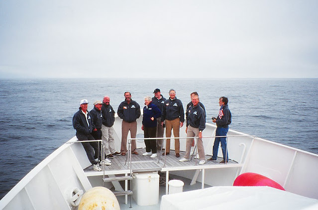
ARCTIC: At the Cutting Edge of Climate Change, #242
ARCTIC, #242:
Before we reach the coast of Greenland, we have about 24hrs. of open-water travel in the Davis Strait of the Labrador Sea. Aside from ogling the occasional HUGE iceberg, there is little else to do except read, watch movies, workout, eat, and of course, drink. Everyone does the latter, so we are quite the happy crew by midday. We navigated south through the night, then began the crossing at first light, and we will arrive at the coast of Greenland about the time it gets dark again. It is a grey and misty day, but we are all pretty drunk, so no one cares. After lunch, Bill Simon surprises all of us with a commemorative gift - a polar fleece jacket sporting an embroidered design stating that we have been part of his Northwest Passage crossing. Of course, everyone then wants a group picture in the jackets, so we all clammar onto the bow platform, and a staff member obliges several shots. From left to right, we are, yours truly; John Loret, a marine biologist, and president of the Explorers Club; “Itasca” captain, Alan Jouning; fearless leader, Bill Simon; John Bockstoce (behind), Arctic historian, archeologist, and writer; Rita Mathews (in front), also a marine biologist, and vice-president of the Explorers Club; Ettore “Barb” Barbatelli, a close friend of Bill’s; Bill Langan (in back) international boat designer who designed “Itasca,” and Bill also won the Fastnet Race in 1993, a very accomplished sailor; Dr. Robert Leach, an orthopedic surgeon, and chief doctor of the U.S. Olympic Committee; and George Gowen, a good friend of both Bill’s, and myself, my cabin-mate for this trip, and the person responsible for getting me on this adventure. TY, George!
PINTEREST: pinterest.com/LittleBearProd
____________________________________________________
photograph(s) © copyright, ROBERT GLENN KETCHUM, 2021,
@RbtGlennKetchum @RobertGKetchum @LittleBearProd #LittleBearProd
Follow Robert Glenn Ketchum's Photographic Activism Online:
LINKEDIN: linkedin.com/in/RbtGlennKetchum
FACEBOOK: facebook.com/RobertGlennKetchum
FACEBOOK: facebook.com/NoPebbleMine.photos
TWITTER: twitter.com/RbtGlennKetchum
TWITTER: twitter.com/RobertGKetchum
SOCIAL MEDIA by #LittleBearProd: LittleBearProd
Wach Gallery: Wach Gallery
Wednesday, March 24, 2021
ARCTIC: At the Cutting Edge of Climate Change, #241
ARCTIC, #241:
Shortly before our special celebration dinner, the sun sets, and although I am slightly inebriated, I bundle up and go out on deck to watch. There is a hazy, grey sky at the horizon, but as the sun sets into it, it lights up the sky above with a pink glow. The first large iceberg comes into view as well, and although it might not appear especially large here, when we pass it, about 1/2-hour later, everyone comes out on deck to have a look. Up close and personal, it is over 100’ high, and about the size of a city block. John Bockstoce, definitely 3-sheets-to-the-wind at this point, immediately identifies it as the one that sank the Titanic. Everyone laughs, but the thought of these huge bergs being out their while we are cruising through the night is as unsettling as it is funny. Captain Jouning has it handled, however, and he has brought us this far, so after viewing this floating spectacle, we retire back inside, and seat ourselves at another glorious meal, where FAR too much wine is served.
PINTEREST: pinterest.com/LittleBearProd
____________________________________________________
photograph(s) © copyright, ROBERT GLENN KETCHUM, 2021,
@RbtGlennKetchum @RobertGKetchum @LittleBearProd #LittleBearProd
Follow Robert Glenn Ketchum's Photographic Activism Online:
LINKEDIN: linkedin.com/in/RbtGlennKetchum
FACEBOOK: facebook.com/RobertGlennKetchum
FACEBOOK: facebook.com/NoPebbleMine.photos
TWITTER: twitter.com/RbtGlennKetchum
TWITTER: twitter.com/RobertGKetchum
SOCIAL MEDIA by #LittleBearProd: LittleBearProd
Wach Gallery: Wach Gallery
Wednesday, March 17, 2021

ARCTIC, #240:
Having departed Pond Inlet, we enter the open water of Baffin Bay, but continue to hug the coast of Baffin Island as we journey south into the Davis Strait. We will cross the Davis Strait to get to Greenland, but because we will be running all night tonite, Captain Jouning does not want to get out into the strait this far north, because it has many huge icebergs floating around, that have been calved off the Greenland icecap, now in epic retreat due to climate change. It is late evening when we turn south, and the last light reflects off of the rugged, mountainous shoreline of Baffin Island. Our trip is nearly over, and we have succeeded in crossing the Northwest Passage in a single season, so Bill Simon is having his staff prepare a lavish, celebratory dinner, and myself, and his other guests are getting bombed, while spending a lot of time in and out of the sauna. There is much more pitch and roll in this open water than there has been for most of the trip, but everyone knew that was coming, and has used their motion nausea meds, so all are having fun, and feeling no ill effects. Party on, Garth!
PINTEREST: pinterest.com/LittleBearProd
____________________________________________________
photograph(s) © copyright, ROBERT GLENN KETCHUM, 2021,
@RbtGlennKetchum @RobertGKetchum @LittleBearProd #LittleBearProd
Follow Robert Glenn Ketchum's Photographic Activism Online:
LINKEDIN: linkedin.com/in/RbtGlennKetchum
FACEBOOK: facebook.com/RobertGlennKetchum
FACEBOOK: facebook.com/NoPebbleMine.photos
TWITTER: twitter.com/RbtGlennKetchum
TWITTER: twitter.com/RobertGKetchum
SOCIAL MEDIA by #LittleBearProd: LittleBearProd
Wach Gallery: Wach Gallery
Wednesday, March 10, 2021

ARCTIC, #239:
We spend this one last evening at anchor while feasting, and a good part of the next day is focused on offloading helicopter fuel we no longer need, and taking in some final supplies. The staff makes numerous journeys back and forth to shore, while myself, and the guests, lounge about. Some workout, some sauna, we all drink, and finally, about 4pm, we raise anchor and begin our exit from the strait upon which Pond Inlet is located, out to the open waters of Baffin Bay. We are going to cross the North Atlantic to Greenland, navigating up Sonde Stromfjord, and eventually anchoring at the small town of Kangerlussuaq, where there is an airport from which we will fly back to the United States.
PINTEREST: pinterest.com/LittleBearProd
____________________________________________________
photograph(s) © copyright, ROBERT GLENN KETCHUM, 2021,
@RbtGlennKetchum @RobertGKetchum @LittleBearProd #LittleBearProd
Follow Robert Glenn Ketchum's Photographic Activism Online:
LINKEDIN: linkedin.com/in/RbtGlennKetchum
FACEBOOK: facebook.com/RobertGlennKetchum
FACEBOOK: facebook.com/NoPebbleMine.photos
TWITTER: twitter.com/RbtGlennKetchum
TWITTER: twitter.com/RobertGKetchum
SOCIAL MEDIA by #LittleBearProd: LittleBearProd
Wach Gallery: Wach Gallery
Wednesday, March 3, 2021

ARCTIC, #238:
After drinks, sauna, and appetizers, we await the service of dinner, so I thought I would take one more stroll about the deck with my cameras. It is a crystal clear, and cold evening, and the sky is a continuous hue of pink, although the sun has set. A large iceberg has drifted into the strait, and it is glowing blue in the shadow of the coming night. The contrast of its color against the rosy sky is dramatic enough, and then it gets even better when a lone kayaker appears to circle the berg. From my perspective, the person is so small that I have to wait for the water to silhoutte the paddler and the boat so they can even be seen. They are close to the left tip of the iceberg in this shot. The scale of this is very “arctic,” and Aperture thought this image perfect for the cover of what would become my book, Northwest Passage.
PINTEREST: pinterest.com/LittleBearProd
____________________________________________________
photograph(s) © copyright, ROBERT GLENN KETCHUM, 2021,
@RbtGlennKetchum @RobertGKetchum @LittleBearProd #LittleBearProd
Follow Robert Glenn Ketchum's Photographic Activism Online:
LINKEDIN: linkedin.com/in/RbtGlennKetchum
FACEBOOK: facebook.com/RobertGlennKetchum
FACEBOOK: facebook.com/NoPebbleMine.photos
TWITTER: twitter.com/RbtGlennKetchum
TWITTER: twitter.com/RobertGKetchum
SOCIAL MEDIA by #LittleBearProd: LittleBearProd
Wach Gallery: Wach Gallery
Wednesday, February 24, 2021

ARCTIC, #237:
After descending from the icecap, we leave the glaciers that we have been flying above, and turn to follow the Bylot Island shoreline, on approach to the village airport of Pond Inlet, where our boat, “Itasca", awaits us in an offshore anchorage. The weather is excellent, so our landing is uneventful, and although we have had an amazing two days of flight-seeing, we are all tired of being on the cargo plane, and glad to get off. Our pilots have been in touch with Captain Jouning aboard “Itasca,” and he knows that we are ready to be “home,” so before our wheels even touch the ground, he has already sent a Zodiac to pick us up. After a month of being aboard with all of us, the crew is dialed in, and when we reach our boat, the three hostesses have our preferred cocktails waiting for us, and someone has already fired up the sauna. Heavenly! Now for yet another awesome dinner.
PINTEREST: pinterest.com/LittleBearProd
____________________________________________________
photograph(s) © copyright, ROBERT GLENN KETCHUM, 2021,
@RobertGKetchum @RobertGKetchum @LittleBearProd #LittleBearProd
Follow Robert Glenn Ketchum's Photographic Activism Online:
LINKEDIN: linkedin.com/in/RbtGlennKetchum
FACEBOOK: facebook.com/RobertGlennKetchum
FACEBOOK: facebook.com/NoPebbleMine.photos
TWITTER: twitter.com/RbtGlennKetchum
TWITTER: twitter.com/RobertGKetchum
SOCIAL MEDIA by #LittleBearProd: LittleBearProd
Wach Gallery: Wach Gallery
Wednesday, February 17, 2021

ARCTIC, #236:
Flying above Bylot Island, we follow a glacier up to, and over the icecap, and now we are following another on our way down to the channel on the other side, across which lies our final destination, Pond Inlet. The particular glacier we are above is quite large, but as we descend, it is intersected by dozens of others. Some are small, coming in from side valleys, but here, the one we fly above merges with an equally huge one coming down a long, broad valley. This union of slowly flowing ice is very wide and winds itself all the way down to the shoreline.
PINTEREST: pinterest.com/LittleBearProd
____________________________________________________
photograph(s) © copyright, ROBERT GLENN KETCHUM, 2021,
@RobertGKetchum @RobertGKetchum @LittleBearProd #LittleBearProd
Follow Robert Glenn Ketchum's Photographic Activism Online:
LINKEDIN: linkedin.com/in/RbtGlennKetchum
FACEBOOK: facebook.com/RobertGlennKetchum
FACEBOOK: facebook.com/NoPebbleMine.photos
TWITTER: twitter.com/RbtGlennKetchum
TWITTER: twitter.com/RobertGKetchum
SOCIAL MEDIA by #LittleBearProd: LittleBearProd
Wach Gallery: Wach Gallery
Wednesday, February 10, 2021

ARCTIC, #235:
The expansive icecap of Bylot Island has generated dozens of glaciers in all directions, all of which are now in significant retreat. Further north above Devon and Ellesmere Island, the colder conditions made the effects of a warming climate less obvious, but here, above Bylot Island, so much retreat has occurred that only one glacier still reaches tidewater. ALL of this has happened in the last 10yrs. according to our contacts at Pond Inlet. Angilaaq Mountain, the center of the icecap, is likely in this picture somewhere, but I thought it would be more obvious. As it is, so many summits are emerging from the icecap, it is unclear to me which is Angilaaq. This will be a VERY different landscape when all the ice is gone.
PINTEREST: pinterest.com/LittleBearProd
____________________________________________________
photograph(s) © copyright, ROBERT GLENN KETCHUM, 2021,
@RobertGKetchum @RobertGKetchum @LittleBearProd #LittleBearProd
Follow Robert Glenn Ketchum's Photographic Activism Online:
LINKEDIN: linkedin.com/in/RbtGlennKetchum
FACEBOOK: facebook.com/RobertGlennKetchum
FACEBOOK: facebook.com/NoPebbleMine.photos
TWITTER: twitter.com/RbtGlennKetchum
TWITTER: twitter.com/RobertGKetchum
SOCIAL MEDIA by #LittleBearProd: LittleBearProd
Wach Gallery: Wach Gallery
Wednesday, February 3, 2021

ARCTIC, #234:
As with the last post, please look at this link for Bylot Island. The exact location of this photograph can be seen on the Google map. In just about the middle of the image, there is a clear “arrowhead” that forms part of the coastal shoreline. That arrowhead is what you see in the picture above, the ragged coast of Bylot. Those bluff faces that drop to the sea are several hundred feet high, and they connect to the foothills mountains, that quickly rise to the summit of Anglaaq Mountain at the center of the icecap. Our flight will proceed directly over that mountain, and then descend to the channel, and the airfield at Pond Inlet.
PINTEREST: pinterest.com/LittleBearProd
____________________________________________________
photograph(s) © copyright, ROBERT GLENN KETCHUM, 2021,
@RobertGKetchum @RobertGKetchum @LittleBearProd #LittleBearProd
Follow Robert Glenn Ketchum's Photographic Activism Online:
LINKEDIN: linkedin.com/in/RbtGlennKetchum
FACEBOOK: facebook.com/RobertGlennKetchum
FACEBOOK: facebook.com/NoPebbleMine.photos
TWITTER: twitter.com/RbtGlennKetchum
TWITTER: twitter.com/RobertGKetchum
SOCIAL MEDIA by #LittleBearProd: LittleBearProd
Wach Gallery: Wach Gallery
Wednesday, January 27, 2021

ARCTIC, #233:
Goodbye Devon Island. Please look at this link. You can see on the Google map the EXACT location of the above picture. Our flight has come over the top of the Devon icecap, and as we return to the coast, we fly above the offshore patch of land which has no white on it, to the right of the main island. The jutting peninsula in this picture is at the bottom, middle of the ice-free island. This tech is AMAZING! From this point, we will cross over the waters of the Baffin Sea, fly directly over the center of Bylot Island, and its icecap, and land at the airport of Pond Inlet. We are less than 1hr. out now, and although I am worn out from two days spent standing for hours by my portal window, I know the film I have shot is a unique record of some remarkable landscapes, and it has been well worth the effort.
PINTEREST: pinterest.com/LittleBearProd
____________________________________________________
photograph(s) © copyright, ROBERT GLENN KETCHUM, 2021,
@RobertGKetchum @RobertGKetchum @LittleBearProd #LittleBearProd
Follow Robert Glenn Ketchum's Photographic Activism Online:
LINKEDIN: linkedin.com/in/RbtGlennKetchum
FACEBOOK: facebook.com/RobertGlennKetchum
FACEBOOK: facebook.com/NoPebbleMine.photos
TWITTER: twitter.com/RbtGlennKetchum
TWITTER: twitter.com/RobertGKetchum
SOCIAL MEDIA by #LittleBearProd: LittleBearProd
Wach Gallery: Wach Gallery
Wednesday, January 20, 2021

ARCTIC, #232:
And now we come to this! A huge glacial tongue extending from land, well out into the sea, and sporting some faces of ice hundreds of feet tall. The tongue closest to the POV here has recently calved off some very large pieces, which are just beginning to drift away, and they are the size of small islands. The intact body of the tongue also hosts some large bluewater pools, and some small streams flow across its surface. This display of ice will be one of the last that I see on Devon Island as we are quickly approaching the coast, and the Northwest Passage channel that leads into Baffin Bay. We will cross that channel, fly briefly above the shores, and icecap, of Bylot Island, and soon find ourselves landing at Pond Inlet, from whence we will return to “Itasca,” anchored just offshore. I am ready for the sauna!
PINTEREST: pinterest.com/LittleBearProd
____________________________________________________
photograph(s) © copyright, ROBERT GLENN KETCHUM, 2021,
@RobertGKetchum @RobertGKetchum @LittleBearProd #LittleBearProd
Follow Robert Glenn Ketchum's Photographic Activism Online:
LINKEDIN: linkedin.com/in/RbtGlennKetchum
FACEBOOK: facebook.com/RobertGlennKetchum
FACEBOOK: facebook.com/NoPebbleMine.photos
TWITTER: twitter.com/RbtGlennKetchum
TWITTER: twitter.com/RobertGKetchum
SOCIAL MEDIA by #LittleBearProd: LittleBearProd
Wach Gallery: Wach Gallery
Wednesday, January 13, 2021

ARCTIC, #231:
I can see through my portal window that we are about to fly over another expansive glacial tongue that covers the landscape and extends considerably out into the ocean from Devon Island, so, although it is slightly redundant of the last post, I add this one more shot on looking back at what we are leaving behind us. The glacial tongue now seems much smaller, but the landscape from which it has retreated has expanded into a world of islands and ponds, and the vision of it remains as abstract as ever. If you painted something like this, it is likely no one would ever realize it is an Arctic landscape, but rather, just see it as shapes and colors. It is only my camera and my words, that configures those forms into a translation of an actual terrain.
PINTEREST: pinterest.com/LittleBearProd
____________________________________________________
photograph(s) © copyright, ROBERT GLENN KETCHUM, 2021,
@RobertGKetchum @RobertGKetchum @LittleBearProd #LittleBearProd
Follow Robert Glenn Ketchum's Photographic Activism Online:
LINKEDIN: linkedin.com/in/RbtGlennKetchum
FACEBOOK: facebook.com/RobertGlennKetchum
FACEBOOK: facebook.com/NoPebbleMine.photos
TWITTER: twitter.com/RbtGlennKetchum
TWITTER: twitter.com/RobertGKetchum
SOCIAL MEDIA by #LittleBearProd: LittleBearProd
Wach Gallery: Wach Gallery
Wednesday, January 6, 2021

ARCTIC, #230:
As our flight back to Pond Inlet where “Itasca” is anchored continues, the spectacle of Devon Island beneath us, unfolds one wonderous vision after another. Even in its retreat, this glacier is HUGE. As it is, it is several miles wide, and very likely it covered the land and ponds to the right not too long ago, as well. While this view unfolds beneath our wings, the concept of the landscape as a pure abstraction keeps flashing through my thoughts. This image could not be more documentary. There is no attempt to “make” it intentionally abstract, BUT it certainly is. What a world! What a two-day flightsee!
PINTEREST: pinterest.com/LittleBearProd
____________________________________________________
photograph(s) © copyright, ROBERT GLENN KETCHUM, 2021,
@RobertGKetchum @RobertGKetchum @LittleBearProd #LittleBearProd
Follow Robert Glenn Ketchum's Photographic Activism Online:
LINKEDIN: linkedin.com/in/RbtGlennKetchum
FACEBOOK: facebook.com/RobertGlennKetchum
FACEBOOK: facebook.com/NoPebbleMine.photos
TWITTER: twitter.com/RbtGlennKetchum
TWITTER: twitter.com/RobertGKetchum
SOCIAL MEDIA by #LittleBearProd: LittleBearProd
Wach Gallery: Wach Gallery
Wednesday, December 30, 2020

ARCTIC, #229:
This post, and the one that will follow it next week, are two of my favorite images from this entire Northwest Passage shoot. They depict an expansive landscape where numerous elements collide, transforming the planet into an abstraction. This is an encompassing view of the Devon Island shoreline where two huge glaciers have spilled down from the icecap to reach the sea. Now, as they retreat, complex wetlands emerge, and the glaciers themselves seem like strange white tongues spilling across the terrain. Scale is difficult to determine, but the upper left, and upper right, on either side of that glacier, are sizable mountain ranges that the glacier has cut through to reach the shore. I don’t know about you, but it boggles MY mind!
PINTEREST: pinterest.com/LittleBearProd
____________________________________________________
photograph(s) © copyright, ROBERT GLENN KETCHUM, 2020, @RobertGKetchum @LittleBearProd #LittleBearProd
Follow Robert Glenn Ketchum's Photographic Activism Online:
LINKEDIN: linkedin.com/in/RbtGlennKetchum
FACEBOOK: facebook.com/RobertGlennKetchum
FACEBOOK: facebook.com/NoPebbleMine.photos
TWITTER: twitter.com/RobertGKetchum
SOCIAL MEDIA by #LittleBearProd: LittleBearProd
Wach Gallery: Wach Gallery
Wednesday, December 23, 2020

ARCTIC, #228:
Our flight path to Pond Inlet over Devon Island leaves the crown of the icecap and begins to descend towards the shoreline edges. The landscape covered by the cap gives way to numerous glacial fingers that have descended from the cap, and the display is spectacular. Exposed terrain flows with rivers generated by the glacial meltback, and huge glacial tongues, retreat from places where they formerly collided, and created an arete, the rock ridge that forms between two glaciers when they impact each other. In this image, as these glaciers separate from their melting, their meltwater flow has created whole new river valleys and wetland complexes. A world is being reborn from beneath the retreat of this icecap. Since new, vibrant life is emerging, why therefore, does climate change concern me? Because these changes are altering world weather patterns, and that does not bode well for any of us. The equatorial zones are going to get MUCH hotter, and North America and Europe are going to see more violent storms, and more Arctic-like conditions in sections of their countries that will not only kill people, but will shut down entire economies in some significant cities like New York, London, and Paris. When Trump said, “Just wait, things are going to get colder,” he was right, without knowing what he was saying. In spite of global warming, changing weather patterns are going thrust significant regions of the world economy into Siberian-like winter conditions, crippling them. Fact! Not fiction. I have been part of this research since the 1970’s.
PINTEREST: pinterest.com/LittleBearProd
____________________________________________________
photograph(s) © copyright, ROBERT GLENN KETCHUM, 2020, @RobertGKetchum @LittleBearProd #LittleBearProd
Follow Robert Glenn Ketchum's Photographic Activism Online:
LINKEDIN: linkedin.com/in/RbtGlennKetchum
FACEBOOK: facebook.com/RobertGlennKetchum
FACEBOOK: facebook.com/NoPebbleMine.photos
TWITTER: twitter.com/RobertGKetchum
SOCIAL MEDIA by #LittleBearProd: LittleBearProd
Wach Gallery: Wach Gallery
Wednesday, December 16, 2020

ARCTIC, #227:
Our flight back to Pond Inlet is now above the few summits that protrude from the massive Devon Island icecap. We have followed the path of a large glacier up to this crown, but now there is nothing but deep snow and ice extending for miles in every direction. Hundreds of glaciers flow down to the sea, generated by the expansive field. I am looking down on a planet shaping process, that has touched every part of the world at some point in time. This process created Yosemite Valley, the Mississippi River corridor, the Great Lakes, and mountain ranges like the Wind Rivers. Thinking about this power makes the hair on the back of my neck stand up. The soft tones of late afternoon light, shining through some hazy clouds, only makes my portal view more ethereal.
PINTEREST: pinterest.com/LittleBearProd
____________________________________________________
photograph(s) © copyright, ROBERT GLENN KETCHUM, 2020, @RobertGKetchum @LittleBearProd #LittleBearProd
Follow Robert Glenn Ketchum's Photographic Activism Online:
LINKEDIN: linkedin.com/in/RbtGlennKetchum
FACEBOOK: facebook.com/RobertGlennKetchum
FACEBOOK: facebook.com/NoPebbleMine.photos
TWITTER: twitter.com/RobertGKetchum
SOCIAL MEDIA by #LittleBearProd: LittleBearProd
Wach Gallery: Wach Gallery
Wednesday, December 9, 2020

ARCTIC, #226:
Our return flight to Pond Inlet is crossing over the massive icecap of Devon Island, and at the moment we are above a huge glacier that we met at the coast, and are now following to the summit of the cap. In the warming conditions of climate change, the surface of the glacier is quite active, and it is dotted by small, sapphire-blue lakes of pooled water, and flowing with numerous turquoise rivers. The hundreds of glaciers that pour down from this icecap, are aggressively calving, and they have completely choked the sea behind us. In this last view before we rise over the icecap summit, to the upper right, you can see the snow and ice clad summits of Ellesmere Island, and the fog-shrouded coast, where we nearly killed ourselves by trying to land through it in Grise Fjord.
PINTEREST: pinterest.com/LittleBearProd
____________________________________________________
photograph(s) © copyright, ROBERT GLENN KETCHUM, 2020, @RobertGKetchum @LittleBearProd #LittleBearProd
Follow Robert Glenn Ketchum's Photographic Activism Online:
LINKEDIN: linkedin.com/in/RbtGlennKetchum
FACEBOOK: facebook.com/RobertGlennKetchum
FACEBOOK: facebook.com/NoPebbleMine.photos
TWITTER: twitter.com/RobertGKetchum
SOCIAL MEDIA by #LittleBearProd: LittleBearProd
Wach Gallery: Wach Gallery
Wednesday, December 2, 2020

ARCTIC, #225:
As our return flight to Pond Inlet continues over the Devon Island icecap, we are following a huge glacial valley that rises in front of us. It is a very active glacier that is “moving” with enough speed to push its mass off the shore, extending itself into the sea. Because it twists and turns in its progress, its surface is scarred by rugged crevasses, and in some places small surface lakes of sapphire-blue water have pooled. Early this morning we were in Otto Fjord, above Ellesmere Island, but we did not fly atop the Ellesmere icecap whose glacier flowed into the fjord. Below us now, however, I am witnessing another sizable one, that our flight is following from the coast into the midst of the cap, and it is a geologic textbook study of what glaciation is, and does.
PINTEREST: pinterest.com/LittleBearProd
____________________________________________________
photograph(s) © copyright, ROBERT GLENN KETCHUM, 2020, @RobertGKetchum @LittleBearProd #LittleBearProd
Follow Robert Glenn Ketchum's Photographic Activism Online:
LINKEDIN: linkedin.com/in/RbtGlennKetchum
FACEBOOK: facebook.com/RobertGlennKetchum
FACEBOOK: facebook.com/NoPebbleMine.photos
TWITTER: twitter.com/RobertGKetchum
SOCIAL MEDIA by #LittleBearProd: LittleBearProd
Wach Gallery: Wach Gallery
Wednesday, November 25, 2020

ARCTIC, #224:
The Devon Island icecap completely covers most of the eastern part of the island, and is impressive to view from the air. There are hundreds of glaciers that descend from it to tidewater, and because of our warming climate, they are actively calving into the ocean so the surrounding waters are choked with sea ice. The coastline is rugged and punctuated by numerous fjords. In some cases, huge glaciers have extended themselves from the shore, out into the ocean without calving off. The one in this picture is over water, about 1/2 mile into the ocean from the coastal shelf.
PINTEREST: pinterest.com/LittleBearProd
____________________________________________________
photograph(s) © copyright, ROBERT GLENN KETCHUM, 2020, @RobertGKetchum @LittleBearProd #LittleBearProd
Follow Robert Glenn Ketchum's Photographic Activism Online:
LINKEDIN: linkedin.com/in/RbtGlennKetchum
FACEBOOK: facebook.com/RobertGlennKetchum
FACEBOOK: facebook.com/NoPebbleMine.photos
TWITTER: twitter.com/RobertGKetchum
SOCIAL MEDIA by #LittleBearProd: LittleBearProd
Wach Gallery: Wach Gallery
Wednesday, November 18, 2020

ARCTIC, #223:
Our flight path from the aborted landing at Grise Fjord, back to Pond Inlet on Baffin Island, is pretty much a straight line that will carry us over the large icecap of Devon Island, and a more shrunken one on Bylot Island. Having been thoroughly shaken by our near-tragic failed landing experience, I don’t take pictures for a few minutes while I catch my breath, but when we arrive at Devon, I can look back and see exactly what we encountered at Grise Fjord. In this picture, at the bottom, is the beginning of the Devon Island icecap. In the far distant right, the mountains rising from the sea are Ellesmere Island. You should note a large patch of fog in the middle of the Ellesmere ranges,..that is Grise Fjord, where just a few short minutes ago, we nearly splashed ourselves on a fjord wall. That is now behind us, however, and most of what all of us just want to do now is get off of this airplane.
PINTEREST: pinterest.com/LittleBearProd
____________________________________________________
photograph(s) © copyright, ROBERT GLENN KETCHUM, 2020, @RobertGKetchum @LittleBearProd #LittleBearProd
Follow Robert Glenn Ketchum's Photographic Activism Online:
LINKEDIN: linkedin.com/in/RbtGlennKetchum
FACEBOOK: facebook.com/RobertGlennKetchum
FACEBOOK: facebook.com/NoPebbleMine.photos
TWITTER: twitter.com/RobertGKetchum
SOCIAL MEDIA by #LittleBearProd: LittleBearProd
Wach Gallery: Wach Gallery
Wednesday, November 11, 2020

ARCTIC, #222:
The community of Grise Fjord is located beneath the summits on the right side of this image. The village is smothered by a dense low fog. Somewhere down there, are numerous homes, a modest cargo port, and an airfield which, apparently, we are going to try to find, and land upon. The pilots take our flight above the fog up into the fjord, and then back down again, to “align” our approach, Then they circle back and dive into the fog bank. We seem to be dropping a good bit of altitude with absolutely NO visibility, and Bill Simon, his guests, and myself, are CLEARLY uneasy with what is happening. One pilot does not help much by saying to the other, “Wow, this fog is nearly down to the deck!” The blur of gray continues to obscure any view, and we are still descending, when it clears suddenly, and the phrase, “Holy shit,” is exclaimed by the co-pilot. We are finally in a place where we have some visibility, and what we ALL now see is VERY sobering. We are so low as to be only a few feet above the water, and we nearly miss striking a native fisherman standing in his boat. A few seconds further on, the docks of the village blow by, as well as the airstrip on which we had hoped to land. This brings the pilots two realizations: one, is that attempting to turn in the fog, in the fjord, is committing suicide, and two, if we fly much further up the fjord we will likely hit a wall. In a split second decision that takes everyone’s breath away, they power up, and begin to climb back through the fog at a VERY steep angle. There are palpable seconds of silence from all of us, and then we break into clear airspace, barely clearing a high ridge. Nothing is said by anyone, but a lot more strange faces are made, and then we are told they will abort the delivery attempt, and take us to “Itasca.” The remainder of the flight is in complete silence.
PINTEREST: pinterest.com/LittleBearProd
____________________________________________________
photograph(s) © copyright, ROBERT GLENN KETCHUM, 2020, @RobertGKetchum @LittleBearProd #LittleBearProd
Follow Robert Glenn Ketchum's Photographic Activism Online:
LINKEDIN: linkedin.com/in/RbtGlennKetchum
FACEBOOK: facebook.com/RobertGlennKetchum
FACEBOOK: facebook.com/NoPebbleMine.photos
TWITTER: twitter.com/RobertGKetchum
SOCIAL MEDIA by #LittleBearProd: LittleBearProd
Wach Gallery: Wach Gallery
Wednesday, November 4, 2020

ARCTIC, #221:
The dusting of snow on the varied landforms I can see through my portal window are an extravagance of designs and textures. I am taking pictures every few minutes of the flight, and I have nearly exhausted the considerable bulk of film I brought with me. Then I hear the pilot’s radio click in, and a voice from Grise Fjord comes on to advise our approach. They reveal the village is socked-in by a dense fog, and that perhaps we should try the supply drop on another day. Our pilots are tired, however, and they do not want to fly to Pond Inlet, and then have to return to Grise Fjord tomorrow, so with a little conversation between themselves, and no consulting with any of us, they explain that they have been to Grise many times, sometimes in similar conditions, and they know the fjord, and the approach well. This is when Bill Simon and his guests all start making strange faces at each other,..and well they should. We are going in!
PINTEREST: pinterest.com/LittleBearProd
____________________________________________________
photograph(s) © copyright, ROBERT GLENN KETCHUM, 2020, @RobertGKetchum @LittleBearProd #LittleBearProd
Follow Robert Glenn Ketchum's Photographic Activism Online:
LINKEDIN: linkedin.com/in/RbtGlennKetchum
FACEBOOK: facebook.com/RobertGlennKetchum
FACEBOOK: facebook.com/NoPebbleMine.photos
TWITTER: twitter.com/RobertGKetchum
SOCIAL MEDIA by #LittleBearProd: LittleBearProd
Wach Gallery: Wach Gallery
Wednesday, October 28, 2020

ARCTIC, #220:
The graphics of the light snow on these plateaus is remarkably diverse, and it is hard not to keep taking pictures. I am going through A LOT of film on this flight, but it is also near the end of the our Northwest Passage journey, so I am comfortable that I will still have enough to sustain the rest of the trip. For sure, I will likely not ever have another opportunity like this, so why not shoot away. Apparently, we are getting close to our supply delivery destination, Grise Fjord, because the pilots have established radio contact. I am at the other end of the plane from the cockpit, and I can’t hear the conversation clearly over the roar of the plane engines, but I do catch the advice that Grise is experiencing a good bit of fog, and it is suggested to our flight team that they “should be advised.” I am not sure what the result of that is going to be, but I am hoping it might clear up before our arrival. I don’t really want to be part of an attempted landing in a fjord with limited visibility.
PINTEREST: pinterest.com/LittleBearProd
____________________________________________________
photograph(s) © copyright, ROBERT GLENN KETCHUM, 2020, @RobertGKetchum @LittleBearProd #LittleBearProd
Follow Robert Glenn Ketchum's Photographic Activism Online:
LINKEDIN: linkedin.com/in/RbtGlennKetchum
FACEBOOK: facebook.com/RobertGlennKetchum
FACEBOOK: facebook.com/NoPebbleMine.photos
TWITTER: twitter.com/RobertGKetchum
SOCIAL MEDIA by #LittleBearProd: LittleBearProd
Wach Gallery: Wach Gallery
Wednesday, October 21, 2020

ARCTIC, #219:
This part of the interior of Ellesmere Island has once again grown more rugged with deeper valleys, and steeper faces on the plateaus. As I did earlier in this trip, I ponder the difficulty of traversing this terrain, and I marvel at the idea of a hike across this landscape. Even with the support of hut system that has been constructed, it seems unimaginable to me that you could carry enough food to sustain the numerous days that would be needed to make such a trek. Most certainly, you would also have the weight of a rifle and ammunition, as there is a large population of polar bears that inhabit this space, and since it does not support much food for them either, I am sure they are hungry and constantly hunting.
PINTEREST: pinterest.com/LittleBearProd
____________________________________________________
photograph(s) © copyright, ROBERT GLENN KETCHUM, 2020, @RobertGKetchum @LittleBearProd #LittleBearProd
Follow Robert Glenn Ketchum's Photographic Activism Online:
LINKEDIN: linkedin.com/in/RbtGlennKetchum
FACEBOOK: facebook.com/RobertGlennKetchum
FACEBOOK: facebook.com/NoPebbleMine.photos
TWITTER: twitter.com/RobertGKetchum
SOCIAL MEDIA by #LittleBearProd: LittleBearProd
Wach Gallery: Wach Gallery
Wednesday, October 14, 2020

ARCTIC, #218:
En route to a mail and supplies delivery at Grise Fjord, our flight is once again over the interior landscape of Ellesmere Island. What I see now is a plateau and valley terrain that is covered by a light snow. Nonetheless, as when we left the last fjord (last post), I can see the U-shape of these valleys has been created by glacial carving, and I realize that here, too, this view is one that is opening up and melting back. At some point in the not-to-distant past EVERYTHING below our wings was under an icecap, and there were no valleys or plateaus showing. They were buried under a massive crown of ice.
PINTEREST: pinterest.com/LittleBearProd
____________________________________________________
photograph(s) © copyright, ROBERT GLENN KETCHUM, 2020, @RobertGKetchum @LittleBearProd #LittleBearProd
Follow Robert Glenn Ketchum's Photographic Activism Online:
LINKEDIN: linkedin.com/in/RbtGlennKetchum
FACEBOOK: facebook.com/RobertGlennKetchum
FACEBOOK: facebook.com/NoPebbleMine.photos
TWITTER: twitter.com/RobertGKetchum
SOCIAL MEDIA by #LittleBearProd: LittleBearProd
Wach Gallery: Wach Gallery
Wednesday, October 7, 2020

ARCTIC, #217:
Our flight reaches the terminus point of the fjord (last post), and we pass back over to the land, but I realize as I gaze down, huge, glacially-carved valleys, intersect the fjord waters on all sides. At some point, before the beginning of our warming climate, this entire terrain within my view was a unified icesheet, covering the now-visible mountains, and stretching out multiple glacial tongues through those valleys, to calve into the fjord. Now, there is no defining icecap, and the open tundra only appears to be dusted by a light snow, not buried beneath hundreds of feet of ice.
PINTEREST: pinterest.com/LittleBearProd
____________________________________________________
photograph(s) © copyright, ROBERT GLENN KETCHUM, 2020, @RobertGKetchum @LittleBearProd #LittleBearProd
Follow Robert Glenn Ketchum's Photographic Activism Online:
LINKEDIN: linkedin.com/in/RbtGlennKetchum
FACEBOOK: facebook.com/RobertGlennKetchum
FACEBOOK: facebook.com/NoPebbleMine.photos
TWITTER: twitter.com/RobertGKetchum
SOCIAL MEDIA by #LittleBearProd: LittleBearProd
Wach Gallery: Wach Gallery
Wednesday, September 30, 2020

ARCTIC, #216:
Our flight leaves the land for awhile, and crosses over the mostly-open water of a broad fjord. It is a spectacle of sapphire blue, dotted with islands, and floes of pack ice. It is radiant, so the ice sparkles like jewels on a crown. Notably, with the presence of water, there is a good deal of fog and clouds present, as well. It is very dreamlike, and I am in a kind of trance, anyway, since I have been standing for several hours, and the drone of the plane has put me in a coma. Fortunately, what passes beneath my window view, periodically shakes me awake with the wonder of it.
PINTEREST: pinterest.com/LittleBearProd
____________________________________________________

ARCTIC: At the Cutting Edge of Climate Change, #215
photograph(s) © copyright, ROBERT GLENN KETCHUM, 2020, @RobertGKetchum @LittleBearProd #LittleBearProd
Follow Robert Glenn Ketchum's Photographic Activism Online:
LINKEDIN: linkedin.com/in/RbtGlennKetchum
FACEBOOK: facebook.com/RobertGlennKetchum
FACEBOOK: facebook.com/NoPebbleMine.photos
TWITTER: twitter.com/RobertGKetchum
SOCIAL MEDIA by #LittleBearProd: LittleBearProd
Wach Gallery: Wach Gallery
Wednesday, September 23, 2020

ARCTIC, #215:
As our flight forges on above Ellesmere Island, en route to a mail, and supplies, delivery at Grise Fjord, the endless succession of snow-capped ranges, expansive valleys, and ice-filled fjords, flows beneath my gaze, through the small portal window. As we are flying in a southerly direction, it seems that it must be growing warmer in the landscape below me, because the snow line is creeping up the slopes, and huge icefields, spawning glaciers, are fewer, and further between. Since refueling, and leaving Eureka base, we have been in the air for quite awhile, and the guests are restless, so Bill Simon asks about our remaining fly-time to Grise, and the pilots respond that we are about 1hr. out. Besides the rising snow line, I am now seeing clouds, and what appears to be banks of fog, which I also assume are do to the land warming. Little do I know what we are getting into.
PINTEREST: pinterest.com/LittleBearProd
____________________________________________________

ARCTIC: At the Cutting Edge of Climate Change, #214:
ARCTIC, #214: As our flight departs the large river valley (last two posts) on Ellesmere Island, we confront landforms equally unusual. Paralleling the meandering river for several miles, a dike of white outcroppings asserts itself from the tundra plain. I do not know if these are something wearing down, or thrusting up, just emerging from the Arctic soil, but they are clearly a very different material than can be seen anywhere else nearby, and they cross the landscape below in a nearly-perfect straight line. As if they are not already obvious enough, the ever-lowering light of the afternoon, lights them up with a glow that is so bright, through my lens, it is like staring at a light bulb. I can only do it for so long, and then it makes my eyes water. There is also a second, exactly parallel ridge, but there is no pale rock showing, or exposed, upon it. Are these “folds” in the landscape created by islands plates crushing into one-another?
PINTEREST: pinterest.com/LittleBearProd
____________________________________________________
photograph(s) © copyright, ROBERT GLENN KETCHUM, 2020, @RobertGKetchum @LittleBearProd #LittleBearProd
Follow Robert Glenn Ketchum's Photographic Activism Online:
LINKEDIN: linkedin.com/in/RbtGlennKetchum
FACEBOOK: facebook.com/RobertGlennKetchum
FACEBOOK: facebook.com/NoPebbleMine.photos
TWITTER: twitter.com/RobertGKetchum
SOCIAL MEDIA by #LittleBearProd: LittleBearProd
Wach Gallery: Wach Gallery
Wednesday, September 16, 2020

ARCTIC, #214: As our flight departs the large river valley (last two posts) on Ellesmere Island, we confront landforms equally unusual. Paralleling the meandering river for several miles, a dike of white outcroppings asserts itself from the tundra plain. I do not know if these are something wearing down, or thrusting up, just emerging from the Arctic soil, but they are clearly a very different material than can be seen anywhere else nearby, and they cross the landscape below in a nearly-perfect straight line. As if they are not already obvious enough, the ever-lowering light of the afternoon, lights them up with a glow that is so bright, through my lens, it is like staring at a light bulb. I can only do it for so long, and then it makes my eyes water. There is also a second, exactly parallel ridge, but there is no pale rock showing, or exposed, upon it. Are these “folds” in the landscape created by islands plates crushing into one-another?
photograph(s) © copyright, ROBERT GLENN KETCHUM, 2020, @RobertGKetchum @LittleBearProd #LittleBearProd
Follow Robert Glenn Ketchum's Photographic Activism Online:
LINKEDIN: linkedin.com/in/RbtGlennKetchum
FACEBOOK: facebook.com/RobertGlennKetchum
FACEBOOK: facebook.com/NoPebbleMine.photos
TWITTER: twitter.com/RobertGKetchum
SOCIAL MEDIA by #LittleBearProd: LittleBearProd
Wach Gallery: Wach Gallery
Wednesday, September 9, 2020

ARCTIC, #213: I stare out of my portal window of the plane, watching the spectacular river valley on Ellesmere Island, unfold beneath me. A large, glacial till filled water course, glows an icy blue as it meanders wildly through a valley pocked with multi-colored lakes, and others that have dried up. It is other-wordly. I feel as though I am in a spacecraft visiting another planet. I have no explanation for how this terrain has come to look like this. I can only gaze at it in wonder. I have no idea what may lie ahead in this flight, but what I am sure of, is that these last two days of flying have taken me above a landscape more far-flung and strange than anything I might ever have imagined. I am SO grateful to be part of this expedition, and to have this remarkable photographic opportunity.
photograph(s) © copyright, ROBERT GLENN KETCHUM, 2020, @RobertGKetchum @LittleBearProd #LittleBearProd
Follow Robert Glenn Ketchum's Photographic Activism Online:
LINKEDIN: linkedin.com/in/RbtGlennKetchum
FACEBOOK: facebook.com/RobertGlennKetchum
FACEBOOK: facebook.com/NoPebbleMine.photos
TWITTER: twitter.com/RobertGKetchum
SOCIAL MEDIA by #LittleBearProd: LittleBearProd
Wach Gallery: Wach Gallery
Wednesday, September 2, 2020

ARCTIC, #212: As our flight wends its way over Ellesmere Island, the succession of fjords, and mountain ranges dripping with glaciers, abates for awhile, and we fly above a vast, snowless river valley. The water of the river is a pale blue, because it carries a lot of glacial till, but there are many lakes, adjacent the river, and they are all of different colors. It is quite a spectacle, and I wonder what makes them all so different. There are also some areas where it is clear, there were previous lakes and wetlands, but they have now dried up. The architecture of this island is an amazing tapestry to view from the air. (If you click on the Ellesmere Island link, you will be able to see the terrain we are flying above. Eureka base, where we started the flight, is in the middle, upper left, and Grise Fjord, where we are going, is in the middle at the bottom. For flightseeing purposes, we are wandering over the snowcapped mountains, rather taking a direct line to get to Grise.)
photograph(s) © copyright, ROBERT GLENN KETCHUM, 2020, @RobertGKetchum @LittleBearProd #LittleBearProd
Follow Robert Glenn Ketchum's Photographic Activism Online:
LINKEDIN: linkedin.com/in/RbtGlennKetchum
FACEBOOK: facebook.com/RobertGlennKetchum
FACEBOOK: facebook.com/NoPebbleMine.photos
TWITTER: twitter.com/RobertGKetchum
SOCIAL MEDIA by #LittleBearProd: LittleBearProd
Wach Gallery: Wach Gallery
Wednesday, August 26, 2020

ARCTIC, #211: If you look at the last post, you can see this summit to the upper right, just beyond that first, snow-covered, rolling ridge. The direction of my flight has now brought me directly above that peak. From this angle you can see all of the mountains NOT covered by the icecap, but to the upper left, they have disappeared under the cap I pointed out in the last post. This amazing planet has been born of icecaps and volcanoes, and the configurations of the land have been carved by ice and water. It does not get more cosmic than that. Have some respect!
photograph(s) © copyright, ROBERT GLENN KETCHUM, 2020, @RobertGKetchum @LittleBearProd #LittleBearProd
Follow Robert Glenn Ketchum's Photographic Activism Online:
LINKEDIN: linkedin.com/in/RbtGlennKetchum
FACEBOOK: facebook.com/RobertGlennKetchum
FACEBOOK: facebook.com/NoPebbleMine.photos
TWITTER: twitter.com/RobertGKetchum
SOCIAL MEDIA by #LittleBearProd: LittleBearProd
Wach Gallery: Wach Gallery
Wednesday, August 19, 2020

ARCTIC, #210: My flight above Ellesmere island affords another view that helps to appreciate the glacier-icecap relationship. In the upper right of this shot, you can see the pronounced summits of a mountain range. If you then scan left, at the head of the exposed valley in the foreground, you can, literally, see peaks that are disappearing under an accumulated icecap. If you follow that to the horizon, the peaks have completely disappeared. An entire mountain range is there, buried by the thousands of years of snowfall, now condensed by weight, into ice so dense it will carve rock. This is the process that built our world! For those that live in North America, a great glacial event defines the entire midwest. The Laurentide Ice Sheet was a massive glacier, born in Canada that eventually extended itself into the upper midwest of North America. Its retreat left us with the glacially gouged Great Lakes, and the melt-out created the fertile sediment deposits that make the Mississippi river valley one of the most productive agricultural areas in our country. Some researchers even believe, that there was at least one catastrophic event, when a huge body of meltwater, pooling in front of the retreating glacier, burst out, and flowed all the way to the gulf, creating the basic course of the future river valley.
photograph(s) © copyright, ROBERT GLENN KETCHUM, 2020, @RobertGKetchum @LittleBearProd #LittleBearProd
Follow Robert Glenn Ketchum's Photographic Activism Online:
LINKEDIN: linkedin.com/in/RbtGlennKetchum
FACEBOOK: facebook.com/RobertGlennKetchum
FACEBOOK: facebook.com/NoPebbleMine.photos
TWITTER: twitter.com/RobertGKetchum
SOCIAL MEDIA by #LittleBearProd: LittleBearProd
Wach Gallery: Wach Gallery
Wednesday, August 12, 2020

ARCTIC, #209: Another amazing example of a glacier “oozing” down a valley from the icecap above. Here the cap has buried the surrounding summits, and the accumulating snow/ice eventually reaches a place where it bridges a low point, and gravity takes over. This descending ice has tremendous weight, and being as solid as it is, the glacier, literally, carves the solid rock and softer earth beneath it. Glacial activity that descends into valleys previously created by rivers, transform the “V” shape of the river valley, to a “U” shape of the glacial bottom, carving up the landscape in spectacular ways,..think YOSEMITE! Ellesmere Island is a continuous succession of mountains that are ice-capped, spilling uncountable glaciers down to the tideline, as you will see over the next few weeks of posting.
photograph(s) © copyright, ROBERT GLENN KETCHUM, 2020, @RobertGKetchum @LittleBearProd #LittleBearProd
Follow Robert Glenn Ketchum's Photographic Activism Online:
LINKEDIN: linkedin.com/in/RbtGlennKetchum
FACEBOOK: facebook.com/RobertGlennKetchum
FACEBOOK: facebook.com/NoPebbleMine.photos
TWITTER: twitter.com/RobertGKetchum
SOCIAL MEDIA by #LittleBearProd: LittleBearProd
Wach Gallery: Wach Gallery
Wednesday, August 5, 2020

ARCTIC, #208: I don’t know which side of the fjord we are crossing above is more interesting, this post, or the last. The impressive river delta in the last post was quite a spectacle, but how about this down-fjord succession of glaciers that stretches as far as the eye can see. OMG! For those that are unfamiliar with glaciers, and how they are generated from an icefield above, this shot makes it more easily understandable. As the icecap grows under successive years of falling snow, the weight of it all turns to solid ice, and as the field grows in weight and depth, it eventually rises to a place where it taller than its contained area, and gravity takes over. Ice begins to “ooze” out from the field like toothpaste from a tube, sliding down to the lower elevation, whatever that is. On Ellesmere there many fluted valleys that run to the fjord, so the glaciers flowed down those to the waterline. Earlier in this blog, I posted pictures of these fluted valley (posts #135-138) on other Arctic islands, but those valleys hosted rivers, and are now glacier-less. Not so, here on Ellesmere. We are much farther north, and although glacial retreat IS happening, it is colder here, and the melt back is moving more slowly.
photograph(s) © copyright, ROBERT GLENN KETCHUM, 2020, @RobertGKetchum @LittleBearProd #LittleBearProd
Follow Robert Glenn Ketchum's Photographic Activism Online:
LINKEDIN: linkedin.com/in/RbtGlennKetchum
FACEBOOK: facebook.com/RobertGlennKetchum
FACEBOOK: facebook.com/NoPebbleMine.photos
TWITTER: twitter.com/RobertGKetchum
SOCIAL MEDIA by #LittleBearProd: LittleBearProd
Wach Gallery: Wach Gallery
Wednesday, July 29, 2020

ARCTIC, #207: If you will look at this Ellesmere Island link you will see we will be flying over numerous fjords and mountain ranges, and it is going to be quite a show. Very shortly after refueling in Eureka, we lift off for Grise and within moments, this appears through my portal window. We leave the land briefly to cross a big fjord, and if you look carefully at the shoreline you will see a massive river delta slowly pushing out into the fjord. Collectively, these past two days are truly one of the most interesting flightsees of my life.
photograph(s) © copyright, ROBERT GLENN KETCHUM, 2020, @RobertGKetchum @LittleBearProd #LittleBearProd
Follow Robert Glenn Ketchum's Photographic Activism Online:
LINKEDIN: linkedin.com/in/RbtGlennKetchum
FACEBOOK: facebook.com/RobertGlennKetchum
FACEBOOK: facebook.com/NoPebbleMine.photos
TWITTER: twitter.com/RobertGKetchum
SOCIAL MEDIA by #LittleBearProd: LittleBearProd
Wach Gallery: Wach Gallery
Wednesday, July 22, 2020

ARCTIC, #206: Eventually Bill Simon, and we guests, re-board the cargo/mail plane in which we have been flying, and lift off the tundra of Otto Fjord. Once again the ice-jammed fjord and the mountains of Ellesmere Island are beneath our wings, and I am standing with my cameras by the door that affords a portal window on the world below. We are now circling back to Eureka base, where will will refuel. Then we will begin the long flight to Pond Inlet, where Simon’s boat, “Itasca,” awaits our return. We will have one other stop at Grise Fjord to deliver mail and supplies to an Inuit village located there, and then we will head “home."
photograph(s) © copyright, ROBERT GLENN KETCHUM, 2020, @RobertGKetchum @LittleBearProd #LittleBearProd
Follow Robert Glenn Ketchum's Photographic Activism Online:
LINKEDIN: linkedin.com/in/RbtGlennKetchum
FACEBOOK: facebook.com/RobertGlennKetchum
FACEBOOK: facebook.com/NoPebbleMine.photos
TWITTER: twitter.com/RobertGKetchum
SOCIAL MEDIA by #LittleBearProd: LittleBearProd
Wach Gallery: Wach Gallery
Wednesday, July 15, 2020

ARCTIC, #205: We will head back to Eureka base in a short while, and although we are all getting cold from the constant light, but chilling breeze, we continue to stand and ponder this spectacle for as long as possible. It is truly otherworldly, and I am struck by how quiet we all are in a group that is constantly talking with each other. Finally the time comes and the pilots round us up. We still have A LOT of flying to do today, as we are going to return to Pond Inlet where ”Itasca” sits at anchor. First, however, we must touch down in Eureka once again to take on a full load of fuel. Then we will fly across the considerable breadth of Ellesmere Island, so I am pretty excited about the possibilities therein, as the weather looks decent, and I know there will be plenty to observe out of small portal window at the back of the plane. Let’s fly!
photograph(s) © copyright, ROBERT GLENN KETCHUM, 2020, @RobertGKetchum @LittleBearProd #LittleBearProd
Follow Robert Glenn Ketchum's Photographic Activism Online:
LINKEDIN: linkedin.com/in/RbtGlennKetchum
FACEBOOK: facebook.com/RobertGlennKetchum
FACEBOOK: facebook.com/NoPebbleMine.photos
TWITTER: twitter.com/RobertGKetchum
SOCIAL MEDIA by #LittleBearProd: LittleBearProd
Wach Gallery: Wach Gallery
Wednesday, July 8, 2020

ARCTIC, #204: When our walking party reaches the shore of the still ice-calving fjord, I feel as though I have been transported to another world. MASSIVE icebergs drift slowly by to an odd orchestra of noises. The chilling breeze has a low whistle, and it is pushing the flat ice plates about, causing them to strike each other with a tinkling sound. The huge icebergs groan and creak, and every once in awhile one rolls, or sheds. Then, booms and splashes are added to the symphony. None of us have ever seen anything like this before, and we all stand in silent awe of the spectacle as the music plays on.
photograph(s) © copyright, ROBERT GLENN KETCHUM, 2020, @RobertGKetchum @LittleBearProd #LittleBearProd
Follow Robert Glenn Ketchum's Photographic Activism Online:
LINKEDIN: linkedin.com/in/RbtGlennKetchum
FACEBOOK: facebook.com/RobertGlennKetchum
FACEBOOK: facebook.com/NoPebbleMine.photos
TWITTER: twitter.com/RobertGKetchum
SOCIAL MEDIA by #LittleBearProd: LittleBearProd
Wach Gallery: Wach Gallery
Wednesday, July 1, 2020

ARCTIC, #203: Out of the plane, Bill Simon, his guests, and our pilots are having a walkabout on the tundra of a recently emerged glacial valley. Ten years previous, the ground we are standing on was under hundreds of feet of ice. This far north, most of the year is VERY dark and cold, so it amazes me to see how quickly growth has bloomed on the land after the retreat of the ice. Admittedly, on close inspection, they look like alien life forms, but these lichen and mosses actual perform an extraordinary service to the world of humans living thousands of miles away. In the study of climate change, scientists have wondered why the planet has not heated up more quickly, because we put a lot of sulphur dioxide into the air. As it turns out, lichen absorb sulphur dioxide, and the Arctic is covered with lichen, so the northern latitudes are a sulphur “sink.” Alien life forms for sure - LOL! Look carefully at this close-up. Nowhere do you see actual soil. Live vegetation covers EVERYTHING! As our walking party approaches the “beach,” we encounter new, and giant, alien forms, as you will see next week.
photograph(s) © copyright, ROBERT GLENN KETCHUM, 2020, @RobertGKetchum @LittleBearProd #LittleBearProd
Follow Robert Glenn Ketchum's Photographic Activism Online:
LINKEDIN: linkedin.com/in/RbtGlennKetchum
FACEBOOK: facebook.com/RobertGlennKetchum
FACEBOOK: facebook.com/NoPebbleMine.photos
TWITTER: twitter.com/RobertGKetchum
SOCIAL MEDIA by #LittleBearProd: LittleBearProd
Wach Gallery: Wach Gallery
Wednesday, June 24, 2020

ARCTIC, #202: As Bill Simon, myself, and the other guest amble across the tundra towards the “beach” of the fjord, I begin to ponder the microscape, rather than the bigger picture. This terrain has only recently melted out from under the glacial ice during the last ten years, which is not a great deal of time, but even in a place this constantly cold, an amazing amount of vegetation has already established itself. Clumps of grasses, a profusion of lichen, and reindeer moss are, literally, everywhere, blanketing the graveled landscape. It amazes me that so much vibrant life could establish itself in these harsh conditions, but clearly it has. What an AMAZING planet we live on, thriving with life, even in extreme places.
photograph(s) © copyright, ROBERT GLENN KETCHUM, 2020, @RobertGKetchum @LittleBearProd #LittleBearProd
Follow Robert Glenn Ketchum's Photographic Activism Online:
LINKEDIN: linkedin.com/in/RbtGlennKetchum
FACEBOOK: facebook.com/RobertGlennKetchum
FACEBOOK: facebook.com/NoPebbleMine.photos
TWITTER: twitter.com/RobertGKetchum
SOCIAL MEDIA by #LittleBearProd: LittleBearProd
Wach Gallery: Wach Gallery
Wednesday, June 17, 2020

ARCTIC, #201: As the vaporous clouds wax and wane, I finally choose this moment to click the shutter. While the day is not particularly cold, and standing in the sun feels warm, there is a steady, slow airflow coming from the head of this former glacial valley, and after some minutes of exposure, it cuts through your clothing, and begins to chill your body. Because I am standing on a rise to make this shot, I am the tallest thing in this landscape besides the mountains, so I am soon slightly frosted, and I retreat down-valley, back towards the plane, and the gaggle of guests who are milling around. Once I am back with the pack, we decide to take a stroll to the “beach” which is in the opposite direction. It may be a beach, but I don’t think there is going to be any sunbathing - LOL!
photograph(s) © copyright, ROBERT GLENN KETCHUM, 2020, @RobertGKetchum @LittleBearProd #LittleBearProd
Follow Robert Glenn Ketchum's Photographic Activism Online:
LINKEDIN: linkedin.com/in/RbtGlennKetchum
FACEBOOK: facebook.com/RobertGlennKetchum
FACEBOOK: facebook.com/NoPebbleMine.photos
TWITTER: twitter.com/RobertGKetchum
SOCIAL MEDIA by #LittleBearProd: LittleBearProd
Wach Gallery: Wach Gallery
Wednesday, June 10, 2020

ARCTIC, #200: Now that we have landed on the tundra and disembarked for a walk-about, Bill Simon and his guests enjoy stretching their legs, and taking pictures of each other (and the pilots - last post). I do my thing as well, and begin to explore the landscape. This former glacial valley is much larger on the ground, then it seemed from the air, and I do a fair amount of walking, but do not get much closer to anything. Vaporous clouds appear and disappear around the large summit closest to where we landed, so I set up to ponder, and picture, the right moment. Behind me, the good doctor, Robert Leach, who shot the previous portrait of the pilots, takes one of yours truly at work. Over the last two days we have spent so many hours in the plane, it is great to be out here now, engaging the vastness of the terrain, and breathing in the crystal clear air.
photograph(s) © copyright, ROBERT GLENN KETCHUM, 2020, @RobertGKetchum @LittleBearProd #LittleBearProd
Follow Robert Glenn Ketchum's Photographic Activism Online:
LINKEDIN: linkedin.com/in/RbtGlennKetchum
FACEBOOK: facebook.com/RobertGlennKetchum
FACEBOOK: facebook.com/NoPebbleMine.photos
TWITTER: twitter.com/RobertGKetchum
SOCIAL MEDIA by #LittleBearProd: LittleBearProd
Wach Gallery: Wach Gallery
Wednesday, June 3, 2020

ARCTIC, #199: I would like to thank one of Bill Simon’s guests, the distinguished Dr. Robert Leach, for taking this portrait while I was off recording the landscape. The taller of the two is our primary pilot, and the other, his co-pilot and navigator. They are wearing layers and layers of clothing, and the Planet Hollywood cap on the pilot could not be more perfect. This entire setting seems a little Jurassic Park, and this is definitely like another planet. I mean, where the F&%# are we? Am I really standing in a dry glacial valley near the top of the world, having just landed without an airstrip on the open tundra, in a cargo plane flown by these two? OMG! Well, shut up, seize the moment, and take some pictures. The party is on, and soon we will walk to the “beach."
photograph(s) © copyright, ROBERT GLENN KETCHUM, 2020, @RobertGKetchum @LittleBearProd #LittleBearProd
Follow Robert Glenn Ketchum's Photographic Activism Online:
LINKEDIN: linkedin.com/in/RbtGlennKetchum
FACEBOOK: facebook.com/RobertGlennKetchum
FACEBOOK: facebook.com/NoPebbleMine.photos
TWITTER: twitter.com/RobertGKetchum
SOCIAL MEDIA by #LittleBearProd: LittleBearProd
Wach Gallery: Wach Gallery
Wednesday, May 27, 2020

ARCTIC, #198: Still very much near the head of the fjord, the pilots have spotted a “dry valley” that once hosted a glacial arm, that has now completely melted away. It has opened a plain of pebble debris within which arctic tundra is trying to establish itself, and although this did not look like a place to land on our flight up, as our plane drops down, I begin to realize how large this valley really is. It is much bigger and flatter than the rocky beach we landed on at Beechey Island ( posts #164-166), and so my anxiety about this maneuver diminishes, and my excitement about being able to get out, walk around, and take some ground level pictures, increases significantly. After a passover of the location they have chosen, they feel we can put wheels on the ground, and with a few bounces, we do. It is cold and sunny outside, with a rather constant low, chilling breeze, and a few vaporous clouds drifting by. In all of this flying, I realize that I have yet to take a picture of the cargo/mail plane in which we are traveling, a twin-prop Bradley. It is one with a lot of wear and tear showing, but it is getting the job done. This is one helleva setting for an airstrip wouldn’t you say?
photograph(s) © copyright, ROBERT GLENN KETCHUM, 2020, @RobertGKetchum @LittleBearProd #LittleBearProd
Follow Robert Glenn Ketchum's Photographic Activism Online:
LINKEDIN: linkedin.com/in/RbtGlennKetchum
FACEBOOK: facebook.com/RobertGlennKetchum
FACEBOOK: facebook.com/NoPebbleMine.photos
TWITTER: twitter.com/RobertGKetchum
SOCIAL MEDIA by #LittleBearProd: LittleBearProd
Wach Gallery: Wach Gallery
Wednesday, May 20, 2020

ARCTIC: At the Cutting Edge of Climate Change, #197:
ARCTIC, #197: Our flightsee adventure FINALLY reaches the end of the fjord where we encounter the remaining face of the retreating glacier. The water below us is dense with ice plates, and studded with huge icebergs. The scale of it all is mind-boggling. It is at this point the pilots swing the plane in a U-turn, as we will now begin to search for a place to back down-fjord, where we can get out, and walk around a bit. As we arc into the turn, my portal window provides this view (above) of the glacial face. The surrounding landscape of Ellesmere Island is VERY mountainous,..TALL mountains, but as they recede into the distance, they disappear under an icecap still thousands of feet thick. The glacier flows down from the cap (upper left) in the gap between the visible mountains, and pours into the fjord. At the edge of its retreat, it is calving off huge chunks, that will drift slowly down-fjord until they melt away. It is a spectacle on a grand scale, and now we are going to ground to see it from that level. Put on your seatbelt and stand by. I am not exactly sure where they expect to land, but we are on our way.
photograph(s) © copyright, ROBERT GLENN KETCHUM, 2020, @RobertGKetchum @LittleBearProd #LittleBearProd
Follow Robert Glenn Ketchum's Photographic Activism Online:
LINKEDIN: linkedin.com/in/RbtGlennKetchum
FACEBOOK: facebook.com/RobertGlennKetchum
FACEBOOK: facebook.com/NoPebbleMine.photos
TWITTER: twitter.com/RobertGKetchum
SOCIAL MEDIA by #LittleBearProd: LittleBearProd
Wach Gallery: Wach Gallery
Wednesday, May 13, 2020

ARCTIC: At the Cutting Edge of Climate Change, #196:
ARCTIC, #196: Our flight is now above the main channel of Otto Fjord, and near the head of the glacier that still remains. The water below our wings is open, but there are evermore chunks of calved glacial ice the size of large buildings. Our pilots are going to take us to the glacial face, and then circle back down the fjord a small distance to find a place to land. I am not so sure about this idea, but there is no doubt there is a whole lot of new land to consider landing upon, now the ice has retreated. These two pilots have been doing this for years, so I am comfortable with whatever choices they make, but we are so far from everywhere, radio contact is spotty, and were we to get stuck some place, it is unlikely we would be rescued. Pretty much, we would be cold toast. Oh well, if we survive, it will be yet another remarkable photo opportunity, and it is about to happen very soon.
photograph(s) © copyright, ROBERT GLENN KETCHUM, 2020, @RobertGKetchum @LittleBearProd #LittleBearProd
Follow Robert Glenn Ketchum's Photographic Activism Online:
LINKEDIN: linkedin.com/in/RbtGlennKetchum
FACEBOOK: facebook.com/RobertGlennKetchum
FACEBOOK: facebook.com/NoPebbleMine.photos
TWITTER: twitter.com/RobertGKetchum
SOCIAL MEDIA by #LittleBearProd: LittleBearProd
Wach Gallery: Wach Gallery
Wednesday, May 6, 2020

ARCTIC: At the Cutting Edge of Climate Change, #195:
ARCTIC, #195: As out flight nears the end of Otto Fjord, the higher elevations of the landscape are causing some diurnal fog, which makes for some very dramatic lightplay on what remains visible. The real drama, however, is the fact that our pilots have been flying over this area several times a month for more than a decade, delivering mail and supplies to various Arctic bases, and when they started, everything you see here was covered by glacial ice. There were NO visible mountains, and the one in this picture is about 900ft. tall. That is not only a STAGGERING amount of lost ice, it is an equally staggering amount of water, now added to the ocean. You can refuse to believe the sea level is rising, but this tremendous volume of water has gone somewhere. You might want to Google flooding information for Miami, Florida, or check out some of the photographs of former homes on the coasts of North and South Carolina, if it all has not been swept completely away as yet.
photograph(s) © copyright, ROBERT GLENN KETCHUM, 2020, @RobertGKetchum @LittleBearProd #LittleBearProd
Follow Robert Glenn Ketchum's Photographic Activism Online:
LINKEDIN: linkedin.com/in/RbtGlennKetchum
FACEBOOK: facebook.com/RobertGlennKetchum
FACEBOOK: facebook.com/NoPebbleMine.photos
TWITTER: twitter.com/RobertGKetchum
SOCIAL MEDIA by #LittleBearProd: LittleBearProd
Wach Gallery: Wach Gallery
Wednesday, April 29, 2020

ARCTIC: At the Cutting Edge of Climate Change, #194:
ARCTIC, #194: As our flight travels up Otto Fjord, we marvel at the distance we fly over that used to be COMPLETELY covered by a glacier, and is now open water studded with huge icebergs. Not only is this glacier retreating ever farther up this fjord, but it was fed by numerous side-glaciers whose valleys are now empty of ice, and exposed (above). We pass by a number of these, and at best, some still flow with water, but all else is a landscape that has emerged only recently from beneath hundreds of feet of glacial ice. It is breathtaking to view, and VERY sobering to consider what the implications of this are. For those of you that don’t believe the climate is changing, IT IS, and far faster than at anytime in human history. The Arctic is the weather generator for the ENTIRE Northern Hemisphere. As the Arctic warms, it will change ALL the climate patterns know to us in North America, and I am very sure we WON’T like what happens. The ostrich can stick its head in the sand, but it will still be eaten by the lion.
photograph(s) © copyright, ROBERT GLENN KETCHUM, 2020, @RobertGKetchum @LittleBearProd #LittleBearProd
photograph(s) © copyright, ROBERT GLENN KETCHUM, 2020, @RobertGKetchum @LittleBearProd #LittleBearProd
Follow Robert Glenn Ketchum's Photographic Activism Online:
LINKEDIN: linkedin.com/in/RbtGlennKetchum
FACEBOOK: facebook.com/RobertGlennKetchum
FACEBOOK: facebook.com/NoPebbleMine.photos
TWITTER: twitter.com/RobertGKetchum
SOCIAL MEDIA by #LittleBearProd: LittleBearProd
Wach Gallery: Wach Gallery
Wednesday, April 22, 2020

ARCTIC: At the Cutting Edge of Climate Change, #193:
ARCTIC, #193: Eventually, we leave the massive channel we have been flying above, and we turn up into a fjord arm that extends to the east. The pilots explain that this is the mouth of Otto Fjord, and they are bringing us here so that we can see one of the most dramatic examples of glacial retreat in all of the Arctic. This fjord is quite long and relatively narrow, and it also has ice flowing, but the ice below us now is not pack ice and flat islands. The ice we are above now is being calved from the glacier at the head of the fjord, and the jumble of of shapes below us are like huge boulders, some as tall as a multi-storied building. We fly on for some time, and the still we do not reach the glacial face, which is all the more remarkable when the pilots tell us that less than 10yrs. ago, the glacier extended all the way to the channel at the entrance to this fjord, and at that time, there was no open water below us, just a tongue of glacial ice, hundreds of feet thick. Given the distance we have covered flying up this fjord, everyone is stunned by how incredibly rapid this melt back has occurred.
photograph(s) © copyright, ROBERT GLENN KETCHUM, 2020, @RobertGKetchum @LittleBearProd #LittleBearProd
Follow Robert Glenn Ketchum's Photographic Activism Online:
LINKEDIN: linkedin.com/in/RbtGlennKetchum
FACEBOOK: facebook.com/RobertGlennKetchum
FACEBOOK: facebook.com/NoPebbleMine.photos
TWITTER: twitter.com/RobertGKetchum
SOCIAL MEDIA by #LittleBearProd: LittleBearProd
Wach Gallery: Wach Gallery
Wednesday, April 15, 2020

ARCTIC: At the Cutting Edge of Climate Change, #192:
ARCTIC, #192: As our morning flight from Eureka heads north to see Otto Fjord, we fly above a huge fjord-like channel that separates Axel Heiberg Island from Ellesmere. The farther north we fly, the more this channel is jammed up with pack ice and large ice islands. These huge, solid ice “islands,” have their late summer surfaces covered with pools of blue meltwater, and no two are alike. They not only vary greatly in size, but each has its own pattern of melt pools, and each also has its own unique color of meltwater. Some of the blue pools are so dark, they are nearly black, and others have pools whose waters are a pale, and VERY luminous, aquamarine. For a good bit of the flight, the ice cover is so dense as to leave little open water, but even in this crowded, close company, everything is flowing about, driven by the winds and ocean currents. It is a very bizarre ballet to watch, and Bill and his guests remain glued to their windows attentive to the spectacle below us, occasional emitting audible oohs, and aahs. It is a spectacular way to start the day, and the weather remains dazzlingly clear so far.
photograph(s) © copyright, ROBERT GLENN KETCHUM, 2020, @RobertGKetchum @LittleBearProd #LittleBearProd
Follow Robert Glenn Ketchum's Photographic Activism Online:
LINKEDIN: linkedin.com/in/RbtGlennKetchum
FACEBOOK: facebook.com/RobertGlennKetchum
FACEBOOK: facebook.com/NoPebbleMine.photos
TWITTER: twitter.com/RobertGKetchum
SOCIAL MEDIA by #LittleBearProd: LittleBearProd
Wach Gallery: Wach Gallery
Wednesday, April 8, 2020

ARCTIC: At the Cutting Edge of Climate Change, #191:
ARCTIC, #191: The pilots tell us the weather is much improved across the Arctic, and that we will have a very good day to flightsee. We do plan on flying all day, eventually returning to Pond Inlet where “Itasca” is anchored, but because we have an early start, they tell us that they will fly us farther north to show us Otto Fjord, where a large glacier is in significant retreat. There is even the possibility we may land somewhere, so all of Bill’s guests seem excited about that, and we are off. As we travel north from Eureka, we fly above the Arctic Ocean between Axel Heiberg Island and Ellesmere which used to have many large glaciers feeding into it. Now they have ALL retreated opening up dozens of fjords. Because the ocean connects to the pack ice flow, it is choked with broken pack ice, and huge, solid islands of ice. Although these islands are flat plates of ice frozen together, on their surface they are covered with a maze of clear blue pools, because the warmth of the summer sun has caused surface melting. Scattered throughout the broken pack ice, they provide an amazing graphic to observe.
photograph(s) © copyright, ROBERT GLENN KETCHUM, 2020, @RobertGKetchum @LittleBearProd #LittleBearProd
Follow Robert Glenn Ketchum's Photographic Activism Online:
LINKEDIN: linkedin.com/in/RbtGlennKetchum
FACEBOOK: facebook.com/RobertGlennKetchum
FACEBOOK: facebook.com/NoPebbleMine.photos
TWITTER: twitter.com/RobertGKetchum
SOCIAL MEDIA by #LittleBearProd: LittleBearProd
Wach Gallery: Wach Gallery
Wednesday, April 1, 2020

ARCTIC: At the Cutting Edge of Climate Change, #190:
ARCTIC, #190: My wolf friend followed me back to the Eureka buildings cluster, where I take this one last gander at the faded light of the night, and the first light of the coming day. The wolf senses my closure as well, and with no encouragement from me, just trots off into the grey. Inside the quonset huts, it seems incredibly warm, but then I realize I am VERY wind-chilled and my hands are barely functioning. Fortunately, the "mess” hall stays open for snacks and drinks 24hrs. of the day, so before bed, I have a nice, slow, hot chocolate, letting the mug revive my fingers. In my room, the curtains are black-out, because of the midnight sun, so it being dark enough to sleep, I do. The morning dawns bright and clear, and the pilots say most of our flight today will benefit from the change, so we have a loud, and crowded breakfast, collect our gear, and await the four-wheel shuttle to get us out to the airstrip. I wonder what will appear through my portal window today?.
photograph(s) © copyright, ROBERT GLENN KETCHUM, 2020, @RobertGKetchum @LittleBearProd #LittleBearProd
Follow Robert Glenn Ketchum's Photographic Activism Online:
LINKEDIN: linkedin.com/in/RbtGlennKetchum
FACEBOOK: facebook.com/RobertGlennKetchum
FACEBOOK: facebook.com/NoPebbleMine.photos
TWITTER: twitter.com/RobertGKetchum
SOCIAL MEDIA by #LittleBearProd: LittleBearProd
Wach Gallery: Wach Gallery
Wednesday, March 25, 2020

ARCTIC: At the Cutting Edge of Climate Change, #189:
ARCTIC, #189: Still well above the actual shoreline, I walk along the bluffs that parallel the water. In so doing I round a rocky point and arrive at valley with a small stream. Because of wind direction, there is also ice trapped against this shore, and the air here is noticeably cooler. My wolfie friend is still tagging along, with his hair flickering in the breeze and the low light, he seems supernatural. I mean seriously, WHERE am I? It is near midnight. I am on an Arctic Island, extremely far north. I am looking out over a fiord filled with broken pack ice, and I am being accompanied in this adventure by a white wolf. “It’s All Too Much!” I finally succumb to the chill of the wind at this overlook, and begin my return to the base buildings. In a few more minutes the sun will not go down, but it will be at its lowest location on the horizon, before beginning to rise again, so it is probably best to gets some sleep. We will fly all day tomorrow, and I want to be prepared for that.
photograph(s) © copyright, ROBERT GLENN KETCHUM, 2020, @RobertGKetchum @LittleBearProd #LittleBearProd
Follow Robert Glenn Ketchum's Photographic Activism Online:
LINKEDIN: linkedin.com/in/RbtGlennKetchum
FACEBOOK: facebook.com/RobertGlennKetchum
FACEBOOK: facebook.com/NoPebbleMine.photos
TWITTER: twitter.com/RobertGKetchum
SOCIAL MEDIA by #LittleBearProd: LittleBearProd
Wach Gallery: Wach Gallery
Wednesday, March 18, 2020

ARCTIC: At the Cutting Edge of Climate Change, #188:
ARCTIC, #188: As the dark of evening grows, I walk in closer to the building cluster at Eureka, but that does not seem to deter my new friend, a white wolf, from continuing to tag along, always at respectful distance. When I first came out to shoot tonight, I walked toward the snow-covered hills, so now I am crossing the base, and headed for a view of the shore. Eureka is located next to a large river system, on the shore of a fjord arm. The peninsula across from us is bathed in fading sunlight, and at this shoreline, the descent to the water’s edge looks less than inviting in the dusky light. This is some seriously rugged terrain.
photograph(s) © copyright, ROBERT GLENN KETCHUM, 2020, @RobertGKetchum @LittleBearProd #LittleBearProd
Follow Robert Glenn Ketchum's Photographic Activism Online:
LINKEDIN: linkedin.com/in/RbtGlennKetchum
FACEBOOK: facebook.com/RobertGlennKetchum
FACEBOOK: facebook.com/NoPebbleMine.photos
TWITTER: twitter.com/RobertGKetchum
SOCIAL MEDIA by #LittleBearProd: LittleBearProd
Wach Gallery: Wach Gallery
Wednesday, March 11, 2020

ARCTIC: At the Cutting Edge of Climate Change, #187:
ARCTIC, #187: I walk about the Eureka base camp area for sometime, with my new friend, a large, white Arctic wolf, following me at a respectful distance, and when I stop to take a shot, the wolf just sits and watches. This landscape is large in scale, and my walking around does not change my perspective a great deal, so as the light grows more dim, and the wolf is still tracking me, I do as suggested, and move closer to the base camp. Buildings, sheds, storage containers, and instrument housings, are scattered all over the immediate terrain. Our group has come to a very curious place. Being in the zone of the midnight sun, the sun will not go down tonight, but it will dip so low as to almost touch the horizon. As it does this, the air also grows colder, and fogs form above summits on the island. Although it is cold, the low light makes everything glow with a warm hue, and snug inside my gear, I continue to explore, because now is the only chance I will have to take pictures. I the morning we are planning to leave quite early for the long flight back to Pond Inlet, where “Itasca” awaits our return.
photograph(s) © copyright, ROBERT GLENN KETCHUM, 2020, @RobertGKetchum @LittleBearProd #LittleBearProd
Follow Robert Glenn Ketchum's Photographic Activism Online:
LINKEDIN: linkedin.com/in/RbtGlennKetchum
FACEBOOK: facebook.com/RobertGlennKetchum
FACEBOOK: facebook.com/NoPebbleMine.photos
TWITTER: twitter.com/RobertGKetchum
SOCIAL MEDIA by #LittleBearProd: LittleBearProd
Wach Gallery: Wach Gallery
Wednesday, March 4, 2020

ARCTIC: At the Cutting Edge of Climate Change, #186:
ARCTIC, #186: Having been assigned rooms in the Eureka base station, we are all eager to eat, and so, as requested, we gather in the dining hall after locating our sleeping quarters. The dining hall is large, and many people are still here, most of whom take note of us as the new arrivals. The menu is surprisingly diverse, and as we ponder it, the “waiter” suggests that the steaks are excellent, so if I remember correctly, that is what EVERYONE orders. It is a very complete meal with a salad and baked potato, so we are all quite happy to have a home and decent food for the night. As we dine, I look about at my new surroundings, and note, in particular, several posters on the walls that sport photographs of Arctic wolves, accompanied by a text that states, “Remember, please do NOT feed the wolves.” When I ask our service person if the posters are meant as a joke about us not getting eaten, he responds that the local wolves have become so familiar to the base, they behave like dogs, and beg for food. The base managers are VERY sincere about NOT encouraging this behavior, thus every door to the outside supports a poster display. When I ask about going out to photograph after dinner, I am told that we are in the zone of the midnight sun, so it may grow twilight dark, but the sun will not go down, AND as I walk about, it will be likely that wolves might follow me at a distance. It is also suggested that one wolf is not threatening, but several maybe cause for caution, and it would be best if I stay closer to the station as the night grows darker. With that advice in mind, I grab my gear and head outside. Within a short walk towards the interior of the island, I come to these bluffs overlooking a river valley that actually has flowing water. It is amazing to see the river, and even more so, considering how dry and barren the surrounding landscape appears. Absorbed by the image in my viewfinder, I finally bring my head up to look around, only to realize that about fifty yards behind me, on a small ridge, a white wolf is seated, staring at me curiously.
photograph(s) © copyright, ROBERT GLENN KETCHUM, 2020, @RobertGKetchum @LittleBearProd #LittleBearProd
Follow Robert Glenn Ketchum's Photographic Activism Online:
LINKEDIN: linkedin.com/in/RbtGlennKetchum
FACEBOOK: facebook.com/RobertGlennKetchum
FACEBOOK: facebook.com/NoPebbleMine.photos
TWITTER: twitter.com/RobertGKetchum
SOCIAL MEDIA by #LittleBearProd: LittleBearProd
Wach Gallery: Wach Gallery
Wednesday, February 26, 2020

ARCTIC: At the Cutting Edge of Climate Change, #185:
ARCTIC, #185: With our plane on the ground, the guests of Bill Simon, the pilots, and I, are only too happy to get out and stretch after many hours of flying in the less-then-traditional seats of the cargo plane. The airstrip is simply a graded dirt field, at some distance from the surrounding assortment of sheds and buildings. Because of that, we await staff from the station that is coming to greet us, and offer us rides on their ATV’s. No one has much luggage to speak of, but I do have my camera gear and bags, and while we await their arrival, I take my first introductory shots. This landscape is rugged, and appears barren, but as I said in the last post, Eureka is known as “The Garden Spot of the Arctic,” and that is not meant as a joke. Weirdly enough, and as spare as it seems, there is more flora and fauna around the Eureka, than anywhere else in all of the high Arctic. Apparently there are some plants, lots of lichen, and quite an array of animals, which include lemmings, Arctic wolves, and Arctic foxes, as well as musk oxen and Arctic hares, which we saw when the plane was landing. Now that we are on the ground and there is no further engine noise, the hares, in fact, have begun to show themselves again, and they pop up everywhere. Our rides arrive and we are chauffeured to the central station, a very large system of interconnected quonset huts, half buried in the ground. Once inside, they are notably warm, and actually quite decently furnished and home-like. We "check-in" and receive room assignments, and then it is suggested that because we have arrived at a rather late hour, we should go to the dining hall to get dinner, before service is stopped.
photograph(s) © copyright, ROBERT GLENN KETCHUM, 2020, @RobertGKetchum @LittleBearProd #LittleBearProd
Follow Robert Glenn Ketchum's Photographic Activism Online:
LINKEDIN: linkedin.com/in/RbtGlennKetchum
FACEBOOK: facebook.com/RobertGlennKetchum
FACEBOOK: facebook.com/NoPebbleMine.photos
TWITTER: twitter.com/RobertGKetchum
SOCIAL MEDIA by #LittleBearProd: LittleBearProd
Wach Gallery: Wach Gallery
Wednesday, February 19, 2020

ARCTIC: At the Cutting Edge of Climate Change, #184:
ARCTIC, #184: We cross a small expanse of water that hosts a number of big icebergs, and then approach the mostly strikingly harsh landscape that I have seen on the entire flight. It is a rocky, ravine-gouged terrain that is unrelentingly bare, and truly, does not look very inviting. It is also quite close to us beneath the plane as we are in descent to land, so I have a very clear, and detailed view of the ruggedness. Out of the pilot window, I can see the dome below me which I have been studying, rises to nearly the level of our descent, and beyond that are mountains, brilliant white from their recent light snowfall. At first, appearing like a speck of odd coloration, then growing in scale as we approach, Eureka base emerges, a strange assortment of quonset huts, sheds, and instrument towers, seemingly quite out-of-place, and rather just plopped onto the hilltop. Our flight path carries us relatively low over the buildings to reveal the gravel strewn runway, and thankfully, frightens off the the three Musk Ox that are standing in the middle of it, grazing. We then fly close to the base of the snow bedecked mountains, and turn to circle back. On line with our runway, at this low altitude, I see white dots haphazardly bouncing about the barren plain, and finally low enough to see more clearly, I realize I am looking at hundreds of white Arctic hare, hopping about, startled by the noise of our engines. Abruptly, we bounce, reverse engines, and slow to a stop. Welcome to Eureka! @ 79˙ North, an average annual high temperature of 4.1˙, an average annual low temperature of -7.6˙, and an average annual rainfall of 1.28” - a polar desert “paradise” near the top of the world, referred to by the residents as “The Garden Spot of the Arctic."
photograph(s) © copyright, ROBERT GLENN KETCHUM, 2020, @RobertGKetchum @LittleBearProd #LittleBearProd
Follow Robert Glenn Ketchum's Photographic Activism Online:
LINKEDIN: linkedin.com/in/RbtGlennKetchum
FACEBOOK: facebook.com/RobertGlennKetchum
FACEBOOK: facebook.com/NoPebbleMine.photos
TWITTER: twitter.com/RobertGKetchum
SOCIAL MEDIA by #LittleBearProd: LittleBearProd
Wach Gallery: Wach Gallery
Wednesday, February 12, 2020

ARCTIC: At the Cutting Edge of Climate Change, #183:
ARCTIC, #183: As our flight drops in altitude, the skies open up more, bathing the rugged terrain with a golden late light show. Ahead are some bays of water in the convoluted coastline, that host a few sizable icebergs, but in the spare landscape, I see no buildings and no airstrip in spite of our miles of visibility. Finally, I hear the pilots asking for acknowledgement from Eureka base, and the speaker cackles back with a disembodied voice, that they are happy to hear from us, wondered where we were, and are awaiting our arrival. That is followed by a, “You are good to land. We have great visibility, and it looks like a lovely evening here in the far north. Wind is off of the fjord, so passover and turn back for your approach.” Thankfully, it appears that after SO many hours, we have finally arrived. The listless guests about the plane have been aroused from their naps, and begin to stretch and shuffle in anticipation of finally disembarking, but I remain glued to my view portal, because “It ain’t over, ‘till it's over,” and I doubt I will ever be here again, so I want to make the most of it.
photograph(s) © copyright, ROBERT GLENN KETCHUM, 2020, @RobertGKetchum @LittleBearProd #LittleBearProd
Follow Robert Glenn Ketchum's Photographic Activism Online:
LINKEDIN: linkedin.com/in/RbtGlennKetchum
FACEBOOK: facebook.com/RobertGlennKetchum
FACEBOOK: facebook.com/NoPebbleMine.photos
TWITTER: twitter.com/RobertGKetchum
SOCIAL MEDIA by #LittleBearProd: LittleBearProd
Wach Gallery: Wach Gallery
Wednesday, February 5, 2020

ARCTIC: At the Cutting Edge of Climate Change, #182:
ARCTIC, #182: During the progress of our flight to Eureka, our altitude has been rather constant, but sometimes it appears we are closer to the landscape, because there are mountains that rise up. However, during our brief passage through the snow squall (post #180), the mesa below us did not seem especially high, but it did seem closer, as though we were dropping in altitude. When we emerged over the bay (last post) we were clearly beneath the clouds, and now, back over land, I am sure we are in a lowering flight path, so maybe Eureka truly is ahead somewhere soon. The terrain below my view portal is VERY stark, without any signs of vegetation at all, but it supports small lakes, and is furrowed by what is clearly channels where water flows, however infrequently. It is also landscape spotted with sunlight, as the weather above us seems to be breaking apart. It is late in the Arctic evening, so we are now seeing late light, and the angle of it is nearly horizontal to the surface of the ground. As a result, only things that rise above the plain are illuminated, but not so much the plain, itself. At one point, this radiant spectacle occurs (above). The upthrust of a ridge, quite literally glows golden in the rakish sunbeams. AND, as I marvel at this vision, we continue to descend in altitude. I hope the landing strip at Eureka appears soon, as the light we will need to land is fading as we fly.
photograph(s) © copyright, ROBERT GLENN KETCHUM, 2020, @RobertGKetchum @LittleBearProd #LittleBearProd
Follow Robert Glenn Ketchum's Photographic Activism Online:
LINKEDIN: linkedin.com/in/RbtGlennKetchum
FACEBOOK: facebook.com/RobertGlennKetchum
FACEBOOK: facebook.com/NoPebbleMine.photos
TWITTER: twitter.com/RobertGKetchum
SOCIAL MEDIA by #LittleBearProd: LittleBearProd
Wach Gallery: Wach Gallery
Wednesday, January 29, 2020

ARCTIC: At the Cutting Edge of Climate Change, #181:
ARCTIC, #181: In the midst of my internal panic about the snowstorm (previous post), and my thoughts about having to land on open terrain and sleep in our cargo plane, things, once again, change abruptly. We fly out of the falling snow and low visibility, and although we are still under darkened skies, the clouds are above us. Beneath us is another body of water, shaded an eerie dark blue, and a single luminous iceberg floats in a bay. Again, I inquire of the pilots where we are, and they respond by saying we are close to Eureka, which gives me no sense of relief because they told me that same thing over an hour ago. I have little choice in this matter, however, so I simply reply that that is great, and go back to my portal window to see what surprises are yet to come. Our passage over this channel of water is quite brief, and then once again, we are above a landscape, that this time seems relatively flat, and it does appear that there is even so some sunlight emerging in front of us. What a strange trip this has been! AND, what a spectacle!
photograph(s) © copyright, ROBERT GLENN KETCHUM, 2020, @RobertGKetchum @LittleBearProd #LittleBearProd
Follow Robert Glenn Ketchum's Photographic Activism Online:
LINKEDIN: linkedin.com/in/RbtGlennKetchum
FACEBOOK: facebook.com/RobertGlennKetchum
FACEBOOK: facebook.com/NoPebbleMine.photos
TWITTER: twitter.com/RobertGKetchum
SOCIAL MEDIA by #LittleBearProd: LittleBearProd
Wach Gallery: Wach Gallery
Wednesday, January 22, 2020

ARCTIC: At the Cutting Edge of Climate Change, #180:
ARCTIC, #180: As we cross the waters of the huge fjord between Axel Heiberg and Ellesmere Islands, the weather over Ellesmere looks increasingly threatening - not a good sign! Then, the worst of my fears are realized when we fly into a snowstorm with low clouds, and marginal visibility. While the graphics of the landscape the falling snow is creating are visually interesting, they do little to allay my apprehensions about whether or not we will be able to land at Eureka station. The pilots seem unconcerned, though, and most of the other guests are dozing to the drone of the engines, so I remain at my portal window, making further images, and praying to gods that this snowy condition is fleeting, rather than growing increasingly worse. As the minutes pass, it does not seem to get any better, in fact, it is worse, so I am now envisioning us looking for a beach or flat plain to land upon, and what it might be like to spend the night in this cargo plane. We would have no choice because we must touch down at Eureka at some point to refuel.
photograph(s) © copyright, ROBERT GLENN KETCHUM, 2020, @RobertGKetchum @LittleBearProd #LittleBearProd
Follow Robert Glenn Ketchum's Photographic Activism Online:
LINKEDIN: linkedin.com/in/RbtGlennKetchum
FACEBOOK: facebook.com/RobertGlennKetchum
FACEBOOK: facebook.com/NoPebbleMine.photos
TWITTER: twitter.com/RobertGKetchum
SOCIAL MEDIA by #LittleBearProd: LittleBearProd
Wach Gallery: Wach Gallery
Wednesday, January 15, 2020

ARCTIC: At the Cutting Edge of Climate Change, #179:
ARCTIC, #179: As droning-on as this flight has been, in the last hour, I must admit that the rapidly changing landscape beneath our wings has not been boring. I have been amazed, however, at the vastness of Axel Heiberg Island, and have begun to wonder if Ellesmere even exists. Then suddenly, things change once again. The river-furrowed, mountainous terrain we have been above, drops off suddenly and slopes down into crystal blue waters, relatively ice-free. When I inquire of the pilots where we are, I am told we are finally leaving Axel Heiberg, and we are above a HUGE fjord, the next landfall will be Ellesmere. The weather at this moment offers a clear expansive view of our new position, and it is VERY dramatic. I am also somewhat relieved because the day is growing late, and there is no Eureka station in site. In addition, ahead of us, there appears to be more stormy skies above Ellesmere, which could still make landing at Eureka impossible. There is no turning back at this point, however, as we do not have enough fuel to go back to Resolute, so we would need to find another place to land, while waiting out the weather. This idea does NOT appeal to me, so I remain hopeful this is one Arctic experience I will not have.
photograph(s) © copyright, ROBERT GLENN KETCHUM, 2020, @RobertGKetchum @LittleBearProd #LittleBearProd
Follow Robert Glenn Ketchum's Photographic Activism Online:
LINKEDIN: linkedin.com/in/RbtGlennKetchum
FACEBOOK: facebook.com/RobertGlennKetchum
FACEBOOK: facebook.com/NoPebbleMine.photos
TWITTER: twitter.com/RobertGKetchum
SOCIAL MEDIA by #LittleBearProd: LittleBearProd
Wach Gallery: Wach Gallery
Wednesday, January 8, 2020

ARCTIC: At the Cutting Edge of Climate Change, #178:
ARCTIC, #178: In the blink of an eye, the expansive Axel Heiberg Island landscape changes again. The huge valley and the high, rolling plains of a few minutes ago, have now become more mountainous, with smaller river valleys cutting through everywhere, dividing my view into a jigsaw-like puzzle of summits and canyons, all intersecting in unexpected angles as far as the view now allows. I have read that there is GREAT hiking on Axel Heiberg and Ellesmere that allow you to traverse a good deal of the islands, but when I see these various configurations of the land unfolding beneath our wings, I can hardly imagine what an effort such a trek must be. I mean, how many days does it take, and how much food do you have to carry? We are flying, and have been for quite sometime, and Axel Heiberg just keeps unfolding range-and-valley, after range-and-valley. Then, too, there are always the polar bears,..lots of them, apparently. I love to hike, and have done so much of my life, but I think this one is a little too over-the-top for my taste. I am happy to be in a plane.
photograph(s) © copyright, ROBERT GLENN KETCHUM, 2020, @RobertGKetchum @LittleBearProd #LittleBearProd
Follow Robert Glenn Ketchum's Photographic Activism Online:
LINKEDIN: linkedin.com/in/RbtGlennKetchum
FACEBOOK: facebook.com/RobertGlennKetchum
FACEBOOK: facebook.com/NoPebbleMine.photos
TWITTER: twitter.com/RobertGKetchum
SOCIAL MEDIA by #LittleBearProd: LittleBearProd
Wach Gallery: Wach Gallery
Wednesday, January 1, 2020

ARCTIC: At the Cutting Edge of Climate Change, #177:
ARCTIC, #177: As the landscape continues to unfold on our flight across Axel Heiberg Island to Eureka base on Ellesmere Island, the snow covered high plains and the crystal clear skies give way to a huge low valley with little snow, and the thermal difference has generated some low clouds. This river system is flowing with a lot of water, and in pondering where it is all coming from, my line of sight follows the flow back into a steeper, more V-shaped gorge, which cuts through the distant mountains for miles and miles. Perhaps the water is generated from snow melting off of the vast high plains, but who knows. Having no “ground truth,” I can only speculate about the gigantic expanse of Axel Heiberg, and the mysteries of this environment, that grow more curious ever minute of this flight.
photograph(s) © copyright, ROBERT GLENN KETCHUM, 2020, @RobertGKetchum @LittleBearProd #LittleBearProd
Follow Robert Glenn Ketchum's Photographic Activism Online:
LINKEDIN: linkedin.com/in/RbtGlennKetchum
FACEBOOK: facebook.com/RobertGlennKetchum
FACEBOOK: facebook.com/NoPebbleMine.photos
TWITTER: twitter.com/RobertGKetchum
SOCIAL MEDIA by #LittleBearProd: LittleBearProd
Wach Gallery: Wach Gallery
Wednesday, December 25, 2019

ARCTIC: At the Cutting Edge of Climate Change, #176:
ARCTIC, #176: As we are still flying over Axel Heiberg Island, it has been quite some time now since the pilots said, “We are almost there (meaning the base at Eureka),” and I am beginning to understand that concept in what I will call “arctic reality.” The scale of this landscape completely changes the meaning of “almost there.” This flight has been droning on for hours, a good bit of which has been above Axel Heiberg, and there is no Eureka base on the horizon as yet. We have crossed over some of the central mountains, and now seem to be above a vast high plain of rolling hills. There are no clouds or fog to be seen anywhere, and the expansive view is jaw-dropping. As you saw in previous posts, the snow melts off of lower elevations, but up here it blankets everything in a dazzling white. When I ask about the VERY distant mountains that I can now see in the crystal clear sky, the pilots tell me that is just more of Axel Heiberg. Amazing! It is SO big and convoluted. Time is slipping away, however, and even with the late light of the Arctic, the shadows are growing, so I hope we see Eureka soon.
photograph(s) © copyright, ROBERT GLENN KETCHUM, 2020, @RobertGKetchum @LittleBearProd #LittleBearProd
Follow Robert Glenn Ketchum's Photographic Activism Online:
LINKEDIN: linkedin.com/in/RbtGlennKetchum
FACEBOOK: facebook.com/RobertGlennKetchum
FACEBOOK: facebook.com/NoPebbleMine.photos
TWITTER: twitter.com/RobertGKetchum
SOCIAL MEDIA by #LittleBearProd: LittleBearProd
Wach Gallery: Wach Gallery
Wednesday, December 18, 2019

ARCTIC: At the Cutting Edge of Climate Change, #175:
ARCTIC, #175: Our flight over Axel Heiberg Island draws closer to central north-south mountain range, and as we continue our traverse, the low lying cloud/fog layers seems to dissipate evermore. Here, summits are rising substantially higher, furrowed by deep river valleys, which amazes me, because it presents a conundrum. Clearly what I am witnessing is a landscape that has been substantially carved by a water flow, significant enough to cut through this myriad of mountains, and yet the Arctic is a desert, that on any given year gets 6” of rain or less. Clearly there is also the contribution of melting snow, but even so, valleys such as the ones depicted above could only exist because of thousands of years of erosion. These are NOT U-shaped glacial valleys created by the ice, they are V-shaped, gouged by water. It is all quite jaw-dropping to me, as I consider all of these thoughts, while trying also make some significant images. What a world!
photograph(s) © copyright, ROBERT GLENN KETCHUM, 2019, @RbtGlennKetchum @LittleBearProd #LittleBearProd
Follow Robert Glenn Ketchum's Photographic Activism Online:
LINKEDIN: linkedin.com/in/RbtGlennKetchum
FACEBOOK: facebook.com/RobertGlennKetchum
FACEBOOK: facebook.com/NoPebbleMine.photos
PINTEREST: pinterest.com/LittleBearProd
SOCIAL MEDIA by #LittleBearProd: LittleBearProd
Wach Gallery: Wach Gallery
Wednesday, December 11, 2019

ARCTIC: At the Cutting Edge of Climate Change, #174:
ARCTIC, #174: As our propeller-driven mail plane slowly drones on, we finally encounter some of the more substantial mountains of Axel Heiberg. We also have brief reveals of some dramatic fjordlands, but for the most part, they are fogged in. Unlike the greater part of the landscape below our wings, the larger summits rise well above the cloud deck. It makes for an interesting shoot on my part, because I am never quite sure when something will suddenly become visible, and then, just as suddenly, disappear once again, beneath the clouds. Clearly there is no going back around for another view, so I stand attentive at my glass portal, and try to take advantage of what ever I am handed. Usually, I am astonished by what I see in this rugged, high Arctic terrain, and I feel so lucky Bill Simon has chosen to make this most interesting side-trip, from our intended Northwest Passage crossing. Most of the guests are napping, bored by the slow advance of our flight. They just want to be out of their uncomfortable seats, and on the ground at Eureka, but I have been standing for hours to make these shots, and I am still wired, gasping at everything that I view. This is the chance of a lifetime, and I am NOT "asleep-at-the-wheel."
photograph(s) © copyright, ROBERT GLENN KETCHUM, 2019, @RbtGlennKetchum @LittleBearProd #LittleBearProd
Follow Robert Glenn Ketchum's Photographic Activism Online:
LINKEDIN: linkedin.com/in/RbtGlennKetchum
FACEBOOK: facebook.com/RobertGlennKetchum
FACEBOOK: facebook.com/NoPebbleMine.photos
TWITTER: twitter.com/RbtGlennKetchum
SOCIAL MEDIA by #LittleBearProd: @LittleBearProd
Wednesday, December 4, 2019

ARCTIC: At the Cutting Edge of Climate Change, #173:
ARCTIC, #173: Axel Heiberg is a huge island with a very convoluted coast, over which we are gradually flying north, and east. As you have seen in the last two posts, our initial encounter was a landscape of rolling mesas, but as we fly farther inland, the valleys grow deeper and the mountains grow higher. What I can view through the portal window of this mail plane is sometimes obscured by clouds, but then it surprises me with a “reveal.” In the image above, the reveal offers up an interesting perspective of how large Axel Heiberg is. The low clouds have briefly parted to uncover foothills carved by deep valleys. In the mid-ground, those foothills have risen into rounded mountains. On the distant horizon, however, VERY substantial summits extend completely above the clouds. These summits are part of the sizable range of peaks that form the north-south spine of this island, and over which our flight will eventually take us.
photograph(s) © copyright, ROBERT GLENN KETCHUM, 2019, @RbtGlennKetchum @LittleBearProd #LittleBearProd
Follow Robert Glenn Ketchum's Photographic Activism Online:
LINKEDIN: linkedin.com/in/RbtGlennKetchum
FACEBOOK: facebook.com/RobertGlennKetchum
FACEBOOK: facebook.com/NoPebbleMine.photos
TWITTER: twitter.com/RbtGlennKetchum
SOCIAL MEDIA by #LittleBearProd: @LittleBearProd
Wednesday, November 27, 2019

ARCTIC: At the Cutting Edge of Climate Change, #172:
ARCTIC, #172: Our flight to Eureka, one of the highest in latitude, manned stations in Canada, is now crossing over Axel Heiberg Island. The island has a VERY convoluted shoreline with many bays, fjords, and extruding peninsulas, and it hosts a tall range of mountains down its north-south axis, that have helped form a huge icecap from which numerous glaciers extend. A sinuous, lightly snow-covered, peninsula (last two posts), greats our arrival, but now we have moved further inland. The peninsula was defined by some gradually up-sloping mesas, but here, further into the interior, the mesas, though not yet mountains, are rising higher, and are more deeply furrowed by river valleys. It appears to be a very rugged terrain from my vantage point. There is still some fog and cloudiness lingering below us, and above them, but it is quite broken, allowing these descriptive views of the landscape, and encouraging us all that we will be able to land at Eureka, because it not likely to be fogged in. We are now within 1/2 hour of our anticipated arrival, and visibility is actually quite good. The pilots feel certain that it will hold.
photograph(s) © copyright, ROBERT GLENN KETCHUM, 2019, @RbtGlennKetchum @LittleBearProd #LittleBearProd
Follow Robert Glenn Ketchum's Photographic Activism Online:
LINKEDIN: linkedin.com/in/RbtGlennKetchum
FACEBOOK: facebook.com/RobertGlennKetchum
FACEBOOK: facebook.com/NoPebbleMine.photos
TWITTER: twitter.com/RbtGlennKetchum
SOCIAL MEDIA by #LittleBearProd: @LittleBearProd
Wednesday, November 20, 2019

ARCTIC: At the Cutting Edge of Climate Change, #171:
ARCTIC, #171: This shot (above) was made just a few flight seconds after the one in the previous post. You can clearly see the rounded rise of the mesa, and what a literal ”tongue” of land the peninsula is. From our altitude, the graceful forms are stunning, and I am besides myself with excitement, because the fog has greatly abated, revealing this unusual landscape. Considering how ice-choked some of the ocean was at lower latitudes, I am surprised to see, as well, that there is almost no ice here,..just the deep blue of the Arctic Ocean, which sets off the snow-dusted island like a sparkling jewel. If you study the Google map of the attached link, you will understand what a convoluted coastline Axel Heiberg has, so for the next 30mins. or so of our flight time, we will go from water to land, back to water, and ultimately, over some tall peaks that rise from the center of the island. Better yet, at the moment it seems we will not be turned back from landing at Eureka, where we hope to overnight, because the fog is really now, an increasingly minimal factor. This day gets better, and stranger, all the time, and we still have some distance to travel.
photograph(s) © copyright, ROBERT GLENN KETCHUM, 2019, @RbtGlennKetchum @LittleBearProd #LittleBearProd
Follow Robert Glenn Ketchum's Photographic Activism Online:
LINKEDIN: linkedin.com/in/RbtGlennKetchum
FACEBOOK: facebook.com/RobertGlennKetchum
FACEBOOK: facebook.com/NoPebbleMine.photos
TWITTER: twitter.com/RbtGlennKetchum
SOCIAL MEDIA by #LittleBearProd: @LittleBearProd
Wednesday, November 13, 2019

ARCTIC: At the Cutting Edge of Climate Change, #170:
ARCTIC, #170: On our plane trip north to Eureka, the fog over the ocean, and some of the islands, created by considerable temperature differentials, obscures the pack ice, and ocean, from view for some time. As a consequence, I do not see much of Cornwall Island, or Amund Ringnes, although I know they are down there, somewhere. When we reach Axel Heiberg, however, things begin to change significantly. Axel Heiberg is VERY mountainous, and quite a large landmass, which alters the temperature differential, so the dense fog is considerably broken up, and as our flight path encounters the first shoreline, this (above) appears quite clearly through my portal window. Below me is a huge peninsula, bathed in fresh snow, and at the moment, a spotlight of sun. The landform is not so much a mountain, as it is a massive, gradually rising mesa. I am VERY excited to see it, and to realize the fog is dissipating, because I was concerned that there might be no visibility at all, as we fly further north. The pilots even cautioned that we might have to turn back to Resolute, if the fog was so dense we could not land at Eureka. That now appears to be less likely, so I cross my fingers these conditions will hold, and turn my attention to the view I have, a mesmerizing sculptural landscape beneath me.
photograph(s) © copyright, ROBERT GLENN KETCHUM, 2019, @RbtGlennKetchum @LittleBearProd #LittleBearProd
Follow Robert Glenn Ketchum's Photographic Activism Online:
LINKEDIN: linkedin.com/in/RbtGlennKetchum
FACEBOOK: facebook.com/RobertGlennKetchum
FACEBOOK: facebook.com/NoPebbleMine.photos
TWITTER: twitter.com/RbtGlennKetchum
SOCIAL MEDIA by #LittleBearProd: @LittleBearProd
Wednesday, November 6, 2019

ARCTIC: At the Cutting Edge of Climate Change, #169:
ARCTIC, #169: Our flight out of Resolute takes us north, across Cornwallis Island and toward Axel Hieberg. The air outside our mail/cargo plane is growing colder as we rise in latitude, causing a lot of cloud cover, and in many places at a lower altitude, banks of fog have been created by the differential temperature between the air, the ocean, and the increasing amount of pack ice. There are some revealing moments, as you see above, when again I am struck by the same sense of abstraction, that the dry valleys of Cornwallis Island triggered in my consciousness (last post). The surface of the ocean reads like the jumble of an incomplete jigsaw puzzle, and in contrast to the deep blue Arctic Ocean, with the white of the ice cover peeking through occasionally, it IS “strange-beautiful,” indeed. Boy, did Jimi Hendrix have that right when he penned those words in the lyric line of a song, and he never even saw this place,..except perhaps, in the dialogue his mind had with the universe.
photograph(s) © copyright, ROBERT GLENN KETCHUM, 2019, @RbtGlennKetchum @LittleBearProd #LittleBearProd
Follow Robert Glenn Ketchum's Photographic Activism Online:
LINKEDIN: linkedin.com/in/RbtGlennKetchum
FACEBOOK: facebook.com/RobertGlennKetchum
FACEBOOK: facebook.com/NoPebbleMine.photos
TWITTER: twitter.com/RbtGlennKetchum
SOCIAL MEDIA by #LittleBearProd: @LittleBearProd
Wednesday, October 30, 2019

ARCTIC: At the Cutting Edge of Climate Change, #168:
ARCTIC, #168: Crossing above Cornwallis Island after leaving the town of Resolute, I am surveying a very barren terrain out of my viewing portal on our mail plane. We are now headed north to Ellesmere Island, where we hope to overnight at Eureka the second highest (latitude) manned base in Canada. Closer to Resolute, when we first take off, the rugged hills are, at least, marked with the furrows of some flowing streams and small rivers, but as we get farther north, the presence of water, increasingly disappears. At the point depicted above, what I am now seeing is a waterless landscape. It is clear that at times, water does flow here, because there are numerous evidential marks on the landscape, but today, there is nothing liquid that is visible. Strangely, as I stare at, and ponder, this stark world below me, the markings on the rolling hills become beautifully abstract. As lifeless, and inhospitable to humans as it seems, there is something about my human consciousness that recognizes, this is still my home, and as Jimi Hendrix penned in the lyrics of one of his songs, this IS “strange-beautiful” to my mind’s eye.
photograph(s) © copyright, ROBERT GLENN KETCHUM, 2019, @RbtGlennKetchum @LittleBearProd #LittleBearProd
Follow Robert Glenn Ketchum's Photographic Activism Online:
LINKEDIN: linkedin.com/in/RbtGlennKetchum
FACEBOOK: facebook.com/RobertGlennKetchum
FACEBOOK: facebook.com/NoPebbleMine.photos
TWITTER: twitter.com/RbtGlennKetchum
SOCIAL MEDIA by #LittleBearProd: @LittleBearProd
Wednesday, October 23, 2019

ARCTIC: At the Cutting Edge of Climate Change, #167:
ARCTIC, #167: Some of us aboard “Itasca” have previously been to Resolute, when some weeks ago, we dropped off our “ice pilot,” brought aboard to help navigate through treacherous straights that were ice-choked. Today, when we depart Beechey Island, we will stop at Resolute to drop some mail, and supplies, AND to refuel, with as much gas as the plane can hold, because from there, we have a long flight north to our overnight destination, Eureka, the second highest (latitude), manned base in Canada. Time is also of the essence because of possible impending weather that might make it difficult to land there, and it grows later in our day with every passing minute. As a consequence, while the pilots, and the airport service crews do their thing, we guests just stretch our legs on the stark Resolute runway, lined with cargo containers and fuel drums. Mission completed, we all scramble back aboard, and we are off! Our flight path will take us due north over Cornwallis Island, the location of Resolute, then over the northernmost tip of Devon Island, onto to Axel Heiberg Island, and then with a slight drift to the west, to Ellesmere Island, where we hope to land, if the weather permits. As we cross Cornwallis, I am struck by the absolute starkness of the terrain beneath our wings. In previous weeks, and through many helicopter excursions above, Baffin, Prince Edward, and Bylot Islands, I have seen, and photographed, some “spare” northern territories, but nothing like this. Although there are many streams and small rivers flowing through deeply furrowed channels, the rest of this island is rocky, seemingly lifeless, and forbidding. I know there is some lichen down there that supports animal, such as Musk Ox, but that is not visible from this altitude. Little else looks inviting. I know, also, that a COLD wind blows constantly across this intimidating landscape, as Resolute is one of the coldest cities in the Arctic on a yearly basis.
photograph(s) © copyright, ROBERT GLENN KETCHUM, 2019, @RbtGlennKetchum @LittleBearProd #LittleBearProd
Follow Robert Glenn Ketchum's Photographic Activism Online:
LINKEDIN: linkedin.com/in/RbtGlennKetchum
FACEBOOK: facebook.com/RobertGlennKetchum
FACEBOOK: facebook.com/NoPebbleMine.photos
TWITTER: twitter.com/RbtGlennKetchum
SOCIAL MEDIA by #LittleBearProd: @LittleBearProd
Wednesday, October 16, 2019

ARCTIC: At the Cutting Edge of Climate Change, #166:
ARCTIC, #166: Our mail plane ride into the high Arctic, has stopped at historian, John Bockstoce’s request to visit memorialized grave sites for members of the ill-fated, expedition of Sir John Franklin in 1845, who hoped to find the Northwest Passage. The graves are located in a deep bay of Beechey Island, so we circled the bay to check the landing site, AND to look for Polar bears, finally putting the plane down on a vast beach of small stones, where we disembark. Bill Simon and his other guests are viewing and taking pictures around the memorial bronze plaques, but I have wandered further away to enjoy the stunning silence and beauty of this stark environment. As dry, cold, and barren of vegetation, as this location is, it is strangely alluring, and the longer I sit and study it, the more I begin to appreciate the vast landscape before me glowing in the light of late afternoon. When we approached our landing, we flew low over the long beach leading to the grave sites, so we could look for Polar bear, and none of us saw anything but the stoney shoreline and cliff bluffs of the island. Nonetheless, one of the pilots is standing guard over our group with a shotgun, even though we can see for hundreds of yards in every direction in the crystal clear air. Suddenly the reverie of my visual trance is shattered when he fires his gun into the air, and tells us all to return to the plane,..quickly!. Sure enough, from out of nowhere, and still a considerable distance down the beach, we are being approached by a curious/hungry Polar bear, so back into the plane, and we are off to our next stop, the town of Resolute on nearby Cornwallis Island.
photograph(s) © copyright, ROBERT GLENN KETCHUM, 2019, @RbtGlennKetchum @LittleBearProd #LittleBearProd
Follow Robert Glenn Ketchum's Photographic Activism Online:
LINKEDIN: linkedin.com/in/RbtGlennKetchum
FACEBOOK: facebook.com/RobertGlennKetchum
FACEBOOK: facebook.com/NoPebbleMine.photos
TWITTER: twitter.com/RbtGlennKetchum
SOCIAL MEDIA by #LittleBearProd: @LittleBearProd
Wednesday, October 9, 2019

ARCTIC: At the Cutting Edge of Climate Change, #165:
ARCTIC, #165: On our mail plane flight into the Arctic, Bill Simon’s guest, and Arctic historian, John Bockstoce, has been sitting with the pilots talking about the landscape below, when he recognizes Beechey Island, famous as landmark because it hosts several graves of crew members from the ill-fated, 1845 expedition of Sir John Franklin, who hoped to discover the Northwest Passage. Bockstoce asks the pilots if we might land on the beach, and visit the memorial plaques that have been erected, and because our plane sports giant tundra tires, we likely can. Before landing, however, we fly around the entire circumference of the bay, studying the possible landing site, and surveying the weather conditions. As we begin a final approach, the pilots bring the plane in low, and quite close to the western shoreline of the bay. Then they ask everyone on that side of the plane to look out of their windows and carefully study the long, rocky beach below, to see if there are any LURKING POLAR BEARS. None of us see anything but barren rock, so we are good to land, and with a surprisingly few bounces, we do. In spite of our shoreline inspection, the pilots have a shotgun, and want to get off first, to assure the beach is safe. When we all do finally step off the plane, most of the guests wander over to take pictures of the memorials. I am struck by the incredible quiet, so I wander away from them to ponder the greater surroundings. As I drink in this barren, uninviting landscape, it grows more wildly beautiful to me with every passing moment. It is very foreign terrain, but it’s spare beauty is a kind of visual haiku, and my camera loves it.
photograph(s) © copyright, ROBERT GLENN KETCHUM, 2019, @RbtGlennKetchum @LittleBearProd #LittleBearProd
Follow Robert Glenn Ketchum's Photographic Activism Online:
LINKEDIN: linkedin.com/in/RbtGlennKetchum
FACEBOOK: facebook.com/RobertGlennKetchum
FACEBOOK: facebook.com/NoPebbleMine.photos
TWITTER: twitter.com/RbtGlennKetchum
SOCIAL MEDIA by #LittleBearProd: @LittleBearProd
Wednesday, October 2, 2019

ARCTIC: At the Cutting Edge of Climate Change, #164:
ARCTIC, #164: Bill Simon, his guests, and I, are “hitching" a ride in a mail plane we have commandeered in the Native village of Pond Inlet, hoping to fly with it as far north into the Arctic as weather will allow. Despite reports of incoming fall storms, our day so far has been quite beautiful, and Devon Island is now beneath our wings. Most of the guests are dozing off in their sling chairs to the drone of the engine noise, but I am standing in the back at the cargo door, because it has a clear glass window through which I can take pictures. At the other end of the plane, John Bockstoce, our “resident” historian for our trip, has settled in with the two pilots, and is chatting them up about what we are flying above. Our plane is bound for the town of Resolute on Cornwallis Island to deliver some mail and supplies, but as we reach the western coast of Devon, another small island appears just offshore, which John recognizes as Beechey Island, historically famous because it is the gravesite location of some of the members of the failed 1845 Northwest Passage exploration by Sir John Franklin All of whom eventually perished. The configuration of the Beechey coastline, provides a very protected harbor, in which the Franklin expedition anchored their ship, and we can clearly see it beneath our flight path. John asks if we might land, and have a look around, and since the plane has giant tundra tires, we can pretty much land anywhere that is flat, and the pilots are comfortable with room to take off. They respond that we probably can land on the shore near the grave memorials, so we circle back and drop in altitude. The grave sites are marked with commemorative bronze plaques, and are on a huge beach of small stones in the deepest recess of the bay. To survey landing conditions, we fly once around the circumference of the bay, so the pilots can study the possible site of touchdown. The view above is looking out of the mouth of the bay as we complete our circle.
photograph(s) © copyright, ROBERT GLENN KETCHUM, 2019, @RbtGlennKetchum @LittleBearProd #LittleBearProd
Follow Robert Glenn Ketchum's Photographic Activism Online:
LINKEDIN: linkedin.com/in/RbtGlennKetchum
FACEBOOK: facebook.com/RobertGlennKetchum
FACEBOOK: facebook.com/NoPebbleMine.photos
TWITTER: twitter.com/RbtGlennKetchum
SOCIAL MEDIA by #LittleBearProd: @LittleBearProd
Wednesday, September 25, 2019

ARCTIC: At the Cutting Edge of Climate Change, #163:
ARCTIC, #163: On our flight from Pond Inlet aboard a mail-cargo plane, we have passed the impressive coastal mountains and broad plains of Bylot Island, and we are now gaining considerable altitude as we cross Lancaster Sound to approach the shore of Devon Island. We have been flying under broken skies, which has offered me some dramatic lighting on the landscape, and it is a surprise to the pilots whose weather report forewarned of a stormy day, to be followed by cold and fog. Whatever might be coming, we are flying right into it, so I remain hopeful the report is wrong, and the day stays like this, so I can take advantage of shooting through the porthole window I have discovered in the entry door. In previous weeks, a lot of fall weather has blown in from the west, and the accompanying winds have driven the pack ice into a concentrated mass against Devon Island’s shoreline. It is amazing to see this and consider the fact that we spent many days working our way through this to get to Pond Inlet. Fortunately for us, the floes were more spread out when we passed, and had not yet been compacted by the direction of the weather. Devon is a big island with a large glacial icefield at the eastern end, and vast rolling hills and tundra valleys as it stretches to the west. The cloud ceiling is high, and the views are unobstructed to the horizons in all directions, so I remain hopefully it will stay that way, and this will be an amazing opportunity to take pictures.
photograph(s) © copyright, ROBERT GLENN KETCHUM, 2019, @RbtGlennKetchum @LittleBearProd #LittleBearProd
Follow Robert Glenn Ketchum's Photographic Activism Online:
LINKEDIN: linkedin.com/in/RbtGlennKetchum
FACEBOOK: facebook.com/RobertGlennKetchum
FACEBOOK: facebook.com/NoPebbleMine.photos
TWITTER: twitter.com/RbtGlennKetchum
SOCIAL MEDIA by #LittleBearProd: @LittleBearProd
Wednesday, September 18, 2019

ARCTIC: At the Cutting Edge of Climate Change, #162:
ARCTIC, #162: Bill Simon and all the guests aboard “Itasca” are now in the mail-cargo plane, starting our long day of flying to Eureka base camp on Ellesmere Island. Leaving the airport at Pond Inlet, we follow the shoreline of Baffin Island out to Baffin Bay, where we make a left turn, crossing over to Bylot Island, and flying above its coastal plain. We have not seen this side of Bylot before, and we are amazed by the rugged, vertical walls. About halfway around the island, we cross above a vast coastal plain that is lichen and tundra covered, pocked with pothole lakes, and laced by rivers and streams everywhere. The plain also has a very distinct red tone, which to me, suggests the surface of Mars. The pilots tell us that 10yrs. ago, this was all beneath the ice of two of the largest glaciers to come down from the icefield atop Angilaaq Mountain. That ice is now many miles from us. Apparently there is also a big, new lake out there, somewhere in this terrain. We are flying away from that view, however, as our flight now begins to cross Lancaster Sound, headed for the coast of Devon Island. Until now, we have been flying fairly low, but as we cross the sound, we begin to climb considerably in altitude.
photograph(s) © copyright, ROBERT GLENN KETCHUM, 2019, @RbtGlennKetchum @LittleBearProd #LittleBearProd
Follow Robert Glenn Ketchum's Photographic Activism Online:
LINKEDIN: linkedin.com/in/RbtGlennKetchum
FACEBOOK: facebook.com/RobertGlennKetchum
FACEBOOK: facebook.com/NoPebbleMine.photos
TWITTER: twitter.com/RbtGlennKetchum
SOCIAL MEDIA by #LittleBearProd: @LittleBearProd
Wednesday, September 11, 2019

ARCTIC: At the Cutting Edge of Climate Change, #161:
ARCTIC, #161: After our last helicopter flight, we all enjoy another great dinner aboard “Itasca,” and then retire early as it is going to be a very long day tomorrow. The helicopter and pilot will return to Yellowknife, Canada, which will take most of the day, and we guests, with Bill Simon, are going flying in a cargo-mail plane that has promised to take us to Eureka base, one of the northernmost weather research stations in the world. Including several stops of interest, this coming flight will take the entire day. We all get started early in the morning, watching as the helicopter lifts off and heads south, then we join the two cargo pilots, and board their plane. It IS a cargo plane, and as such it does not really have seats, they are more like saggy, sling chairs - not especially comfortable. More disappointing to me, this is an old plane with a lot of Arctic miles on it, and the noticeable victims of the wear and tear are the windows. They are all scratched, and hazy plexiglass, and they will making taking pictures a nightmare, if not impossible. The other guests allow me to choose my seat so I will have the best window available, but there is not much improvement, so I resign myself to the fact that we will make some stops, and I will be able to shoot then, when we are on the ground. After the plane takes off, Bockstoce gets up and goes to the cockpit as he wants to talk with the pilots. There is little turbulence, and I am so uncomfortable, I get up as well. There are some large duffel bags at the back of the plane near the entry door, and it looks like they will be more comfortable to lay upon, than sitting in the chair. Then, I have an amazing moment. I realize the entry door has a fairly big porthole window, it is glass, and it is quite clear. I can stand at the door and shoot, as long as I keep my lens in the middle of the window, avoiding some optical distortion at edges of the glass. I have no sooner made this welcome discovery, when my first chance to use it arrives. Our flight is taking us north and west, back over Baffin Bay, into Lancaster Sound, and along the shore of Devon Island. At the moment, however, we are above the glacial debris plain we visited yesterday afternoon by helicopter. Because we are flying at a higher altitude, I have a more encompassing view, and I can also see where a new, sizable stream of water has appeared since yesterday.
photograph(s) © copyright, ROBERT GLENN KETCHUM, 2019, @RbtGlennKetchum @LittleBearProd #LittleBearProd
Follow Robert Glenn Ketchum's Photographic Activism Online:
LINKEDIN: linkedin.com/in/RbtGlennKetchum
FACEBOOK: facebook.com/RobertGlennKetchum
FACEBOOK: facebook.com/NoPebbleMine.photos
TWITTER: twitter.com/RbtGlennKetchum
SOCIAL MEDIA by #LittleBearProd: @LittleBearProd
Wednesday, September 4, 2019

ARCTIC: At the Cutting Edge of Climate Change, #160:
ARCTIC, #160: Of all the images I shoot on this voyage, this is one of my favorites, and one of my most beautiful prints. It is the result of John Bockstoce, our helicopter pilot, and me, chasing broken sunlight across the steep shorelines faces of Bylot Island. We are headed back to the Native village of Pond Inlet, where our boat, “Itasca” is anchored, and this is our last flight in the helicopter, because it will depart tomorrow for Yellowknife, Canada. This is the last gift of being able to photograph from such a great platform. This image is also the last to close my resulting Aperture book, Northwest Passage. Part of my desire to see the Arctic was fueled by the amazing natural history journal, Arctic Dreams, authored by my friend, Barry Lopez, one of America’s most important contemporary writers. In the Aperture style of publishing, significant quotes are often used to offset pictures, so I asked Barry, if we could use quotes from Arctic Dreams, to which he kindly consented. The pairing of the quote to this image is the PERFECT closure to the book, so I repeat it here: American landscape painting in the 19th Century reveals a struggle with light and space that eventually set it apart from a contemporary European tradition of pastoral landscapes framed by trees, the world viewed from a carriage window. American painters meant to locate an actual spiritual presence in the North American landscape. The atmosphere of these paintings is silent and contemplative. They suggest a private rather than public encounter with the land. Several critics have described as well, a peculiar “loss of ego” in the paintings. The artist disappears. The authority of the work lies, instead, with the land. And the light in them is like a creature, a living, integral part of the scene. The landscape is luminous, imposing, real….
photograph(s) © copyright, ROBERT GLENN KETCHUM, 2019, @RbtGlennKetchum @LittleBearProd #LittleBearProd
Follow Robert Glenn Ketchum's Photographic Activism Online:
LINKEDIN: linkedin.com/in/RbtGlennKetchum
FACEBOOK: facebook.com/RobertGlennKetchum
FACEBOOK: facebook.com/NoPebbleMine.photos
TWITTER: twitter.com/RbtGlennKetchum
SOCIAL MEDIA by #LittleBearProd: @LittleBearProd
Wednesday, August 28, 2019

ARCTIC: At the Cutting Edge of Climate Change, #159:
ARCTIC, #159: Bylot Island is VERY rugged, with ragged, vertical cliffs plunging to the ocean. There are few beaches, and the ones that exist are where glaciers have retreated. Bylot Island has a huge icecap and glaciers stream down from it on all sides of the island. In the last two decades, however, many of those have retreated miles inland. On the shore we are flying above, there used to be at least 7 glaciers that came to tidewater, and there are none visible on this flight. In fact, we never actually see a glacier in any of the new valleys, they have retreated so far. The rocky coastal cliffs ARE putting on quite a show, though, in the broken light filtering through holes in the occluded sky, so I ask our pilot if we can fly more closely to them, which he obliges. On approach, I am surprised how tall they rise, because we have been viewing them from a good distance out over the water, I am taken aback by their scale when we get up close and personal. The light playing across the shattered faces, further defines the craggy features, and all three of us in the helicopter quietly gasp as the display changes significantly from minute-to-minute, each more stunning than the last.
photograph(s) © copyright, ROBERT GLENN KETCHUM, 2019, @RbtGlennKetchum @LittleBearProd #LittleBearProd
Follow Robert Glenn Ketchum's Photographic Activism Online:
LINKEDIN: linkedin.com/in/RbtGlennKetchum
FACEBOOK: facebook.com/RobertGlennKetchum
FACEBOOK: facebook.com/NoPebbleMine.photos
TWITTER: twitter.com/RbtGlennKetchum
SOCIAL MEDIA by #LittleBearProd: @LittleBearProd
Wednesday, August 21, 2019

ARCTIC: At the Cutting Edge of Climate Change, #158:
ARCTIC, #158: The boulder strewn, glacial debris beaches and the newly opened fjord, John Bockstoce and I have just explored in our helicopter flight, bring us to the point where the Baffin Island rounds to the east, and opens onto Baffin Bay. We still have fantastic dappled lighting under a sky of thin clouds, and there is little turbulence, so we fly out, and UP, over the bay to take in the view. To the west there is fog over the water, which suggests there are ice flows beneath it, but to the east (the view above), there is virtually no ice visible, and out there under that darkening sky, lies Greenland. We circle about out here for a bit, taking it all in, as this is likely the last helicopter flight we will make, and then we return to the channel leading back to Pond Inlet, where “Itasca” is anchored. Rather than overfly the same shoreline we followed on the way out, we swing across the channel and approach the steep, and very dramatic coastline of Bylot Island.
photograph(s) © copyright, ROBERT GLENN KETCHUM, 2019, @RbtGlennKetchum @LittleBearProd #LittleBearProd
Follow Robert Glenn Ketchum's Photographic Activism Online:
LINKEDIN: linkedin.com/in/RbtGlennKetchum
FACEBOOK: facebook.com/RobertGlennKetchum
FACEBOOK: facebook.com/NoPebbleMine.photos
TWITTER: twitter.com/RbtGlennKetchum
SOCIAL MEDIA by #LittleBearProd: @LittleBearProd
Wednesday, August 14, 2019

ARCTIC: At the Cutting Edge of Climate Change, #157:
ARCTIC, #157: In our helicopter, John Bockstoce and I circle above a large glacier in serious retreat to the east of Pond Inlet. We are in awe of the spectacle below. A massive, decaying glacial finger descending from a huge icecap is cracked and scarred by water and weather, and no new snow has covered the etched surface. Streams of mud and water pour out of every ice crevice, contributing to the beach of rubble. Then, while we are observing it all, something surprising happens. One of the gullies created in the tongue of the glacier is broader and flowing with more volume than the rest, but all of them are coursing with pale blue water. Abruptly, the larger stream begins to get noticeably milky, then quickly becomes chocolate in color. Apparently, we are witnessing a flash-flood of mud being carried suddenly into the icy stream. When it bursts onto the beach, it flows across it for a short while, but the force of water quickly cuts a deep channel down to the gravel, an continues out to the sea. When John and I relate this event upon our return to Pond Inlet, several of his local friends tell us these occurrences represent serious problems and dangers in their daily lives. The villagers believe these floes happen at the warmest part of the day, and are sometimes triggered by surface lakes collapsing farther up in the icefield. The torrent might remain as water, or it could collect rocks and/or mud in its descent. The flow will eventually abate as the temperature decreases, but fishermen and hunters have found themselves blocked from passage, and having to wait to cross back over such places, that were not there when they passed through earlier in the day.
photograph(s) © copyright, ROBERT GLENN KETCHUM, 2019, @RbtGlennKetchum @LittleBearProd #LittleBearProd
Follow Robert Glenn Ketchum's Photographic Activism Online:
LINKEDIN: linkedin.com/in/RbtGlennKetchum
FACEBOOK: facebook.com/RobertGlennKetchum
FACEBOOK: facebook.com/NoPebbleMine.photos
TWITTER: twitter.com/RbtGlennKetchum
SOCIAL MEDIA by #LittleBearProd: @LittleBearProd
Wednesday, August 7, 2019

ARCTIC: At the Cutting Edge of Climate Change, #156:
ARCTIC, #156: While John Bockstoce and I are enjoying our last chance to fly in the helicopter, we are also exploring some notable evidence of glacial retreat due to climate warming, and flying east of the village of Pond Inlet, we are now above a VERY long, broad beach that is comprised entirely of glacial boulder rubble left by the ice retreating from the tideline. We fly past a broad new valley that has opened up, and then come to a fjord whose canal has only recently melted open. It is quite a big canal, and the blue water extends well into the interior of the island, so John encourages our pilot to explore it. As we near the terminus, where ice cover begins, a large glacier descends from the mainland icecap, and is creating a similar boulder strewn beach at the edge of the fjord. The decaying glacier leaves much to study, so the pilot circles us about several times while John marvels, and I shoot. John notes that ALL of the foothills in this image, were beneath glacial ice when he visited 4yrs. ago.
photograph(s) © copyright, ROBERT GLENN KETCHUM, 2019, @RbtGlennKetchum @LittleBearProd #LittleBearProd
Follow Robert Glenn Ketchum's Photographic Activism Online:
LINKEDIN: linkedin.com/in/RbtGlennKetchum
FACEBOOK: facebook.com/RobertGlennKetchum
FACEBOOK: facebook.com/NoPebbleMine.photos
TWITTER: twitter.com/RbtGlennKetchum
SOCIAL MEDIA by #LittleBearProd: @LittleBearProd
Wednesday, July 31, 2019

ARCTIC: At the Cutting Edge of Climate Change, #155:
ARCTIC, #155: As John Bockstoce and I are taking one more helicopter flight before the pilot leaves us and returns to other work in Canada, we have flown away from Pond Inlet, to the east. At the point our bay opens to the greater sound, there appears a vast gravel and boulder strewn shore on the mainland side, beneath the mainland icecap. John is stunned to see this, as he explains that he was here 4yrs. previously, and that no such beach existed. The ice in most valleys came to the tide line, and many of the lower foothills were covered by the ice. Today, there is NO glacial ice visible at the shore, and little can be seen in any of the newly opened valleys. There is a very broad, ice-free river valley that previously had a glacier, which we pass, and a new fjord has opened quite a lengthy canal that was not there on his last visit, either. All of this puts John into quite a wild twitter of disbelief about the scale and rate of change.
photograph(s) © copyright, ROBERT GLENN KETCHUM, 2019, @RbtGlennKetchum @LittleBearProd #LittleBearProd
Follow Robert Glenn Ketchum's Photographic Activism Online:
LINKEDIN: linkedin.com/in/RbtGlennKetchum
FACEBOOK: facebook.com/RobertGlennKetchum
FACEBOOK: facebook.com/NoPebbleMine.photos
TWITTER: twitter.com/RbtGlennKetchum
SOCIAL MEDIA by #LittleBearProd: @LittleBearProd
Wednesday, July 24, 2019

ARCTIC: At the Cutting Edge of Climate Change, #154:
ARCTIC, #154: Well beyond the developed areas of Pond Inlet, we still see these fish camps at coveted locations. No one is here at the moment, as you only reach this by boat, and none is ashore. I note the value of the freshwater stream at the location, and wonder if it might soon cease to flow as it is dependent upon glacial melt, and the ones near here are disappearing rapidly. I have a bright, overcast afternoon with which to work, and John is providing “insightful” dialogue, as he loves to do. For some time, we follow the shoreline headed north and east of Pond Inlet. There are numerous small glacial valleys we pass over along the way, and ALL of them are now ice-free. Some no longer have flowing water, either. Our flight then rounds the edge of the shore, turning us directly east, and bringing us abreast of the still massive icecap above the village. Be sure to follow the link I have provided, and use the + to enlarge the detail. These are especially good satellite images, and you can really see the complexity of the bay and shore above which we are flying. The lesser summits of the shoreline were previously under ice and could not be seen, according to John, but they have now melted out, opening up ice-free river valleys, and saltwater fjords. I would love to fly up one of the valleys, or get higher above the whole landscape, but there is a lot of katabatic wind off of the icefield, and our pilot prefers to stay bound to the shore.
photograph(s) © copyright, ROBERT GLENN KETCHUM, 2019, @RbtGlennKetchum @LittleBearProd #LittleBearProd
Follow Robert Glenn Ketchum's Photographic Activism Online:
LINKEDIN: linkedin.com/in/RbtGlennKetchum
FACEBOOK: facebook.com/RobertGlennKetchum
FACEBOOK: facebook.com/NoPebbleMine.photos
TWITTER: twitter.com/RbtGlennKetchum
SOCIAL MEDIA by #LittleBearProd: @LittleBearProd
Wednesday, July 17, 2019

ARCTIC: At the Cutting Edge of Climate Change, #153:
ARCTIC, #153: During our lunch aboard “Itasca,” Bill Simon proposes an idea to all of us. Since we have now succeeded in crossing the Northwest Passage in a relatively short amount of time, we are way ahead of where we thought we might be, and there are still many interesting things to see. Maybe we can financially persuade the cargo pilots we met (last post) to take us to the North Pole. It seems like a good idea at the time, so we all agree, and after lunch we go ashore to find them and discuss the idea. The cargo pilots only sort-of-know, who Bill Simon is, so they are “amused” by the proposal, but decline. Turns out, it would require masterful flight planning, AND a stash of gas out on the polar ice somewhere, because it would be such a long flight. Nonetheless, Bill IS offering both money and gas, so they propose an alternative idea. We can all fly with them to the villages and “sightsee” along the way, because we can land on tundra and beaches. Our journey will take two days, and we will overnight at Eureka Base, the northernmost manned research base in the Arctic. That sounds interesting to all of us, and Bill and John Bockstoce are totally fired up, so it is agreed we will fly north tomorrow in a cargo plane, and tonight the pilots will join us aboard “Itasca” for dinner. It is also too late in the day for the helicopter pilot to start his journey south to Yellowknife, so he is invited as well. Realizing we still have the helicopter, I ask the pilot if we can fly, which Bill and John overhear. Now EVERYONE wants to fly. Bockstoce has been to Pond Inlet before, and is surprised to see it so ice-free. Given some of the climate discussions this morning, he and I agree we want to look at some of those changes, and Bill allows us to go first as the afternoon light is good, and he expects me to make pictures. In the last post, you see the main street of Pond Inlet, and the airport is just out-of-frame to the right. Flying over the town, the village quickly goes by, leaving those who have chosen to live a bit farther out. Here you can see small settlements spread across several mesas. The pipeline is freshwater.
photograph(s) © copyright, ROBERT GLENN KETCHUM, 2019, @RbtGlennKetchum @LittleBearProd #LittleBearProd
Follow Robert Glenn Ketchum's Photographic Activism Online:
LINKEDIN: linkedin.com/in/RbtGlennKetchum
FACEBOOK: facebook.com/RobertGlennKetchum
FACEBOOK: facebook.com/NoPebbleMine.photos
TWITTER: twitter.com/RbtGlennKetchum
SOCIAL MEDIA by #LittleBearProd: @LittleBearProd
Wednesday, July 10, 2019

ARCTIC: At the Cutting Edge of Climate Change, #152:
ARCTIC, #152: “Itasca’s” arrival at Pond Inlet is well into the evening, and Bill Simon suggests we await going ashore until morning, instead having a good-bye dinner aboard with our pilot, who has until now, eaten with the staff. After a great meal, and a good deal of drinking, we all retire and sleep well. We have crossed through the Northwest Passage, the first yacht to accomplish that in a single season. From here on out, we will see huge icebergs from Greenland in the Atlantic, but there will be no surface ice, or blocking flows. Ultimately, our last port is Greenland, from where we will all fly home. In the morning, Bill is “eager to engage” with Pond Inlet, so an earlier-than-usual breakfast is had by all, and then we go ashore. The helicopter pilot has one last task - to ferry the MANY multi-gallon canisters for gas, off of our boat, and to the local airport. As much as we flew, we actually carried nearly twice as much gas as we used. That Bill, always on the safe side! Visiting villages usually involves walking around, and often meeting people that John Bockstoce knows. Our group does just that for most of the morning, while the pilot proceeds with the offload. We plan to connect with him at the airport before lunch. We do meet people in our socializing meander, and several times there are comments from the Natives, that we have succeeded in our crossing, because of climate change. They also say they see less ice in their bay, and most nearby glaciers have melted back from tideline. Upon return to the airport, Bill is considering re-selling the unused gas for the helicopter to the town, as their fuel prices are sky-high, when a curious thing happens - a cargo-like mail plane lands, and the two pilots come into the terminal building, where we are gathered. Bill and John both engage them immediately about what they do, where they fly, and where they are going. They respond that they are on a regular mail and supplies “loop” to numerous villages, much farther north. As we guests return to “Itasca” for lunch, I can clearly see that Bill’s “wheels” are turning.
photograph(s) © copyright, ROBERT GLENN KETCHUM, 2019, @RbtGlennKetchum @LittleBearProd #LittleBearProd
Follow Robert Glenn Ketchum's Photographic Activism Online:
LINKEDIN: linkedin.com/in/RbtGlennKetchum
FACEBOOK: facebook.com/RobertGlennKetchum
FACEBOOK: facebook.com/NoPebbleMine.photos
TWITTER: twitter.com/RbtGlennKetchum
SOCIAL MEDIA by #LittleBearProd: @LittleBearProd
Wednesday, July 3, 2019

ARCTIC: At the Cutting Edge of Climate Change, #151:
ARCTIC, #151: Shortly after the helicopter pilot and I return to “Itasca,” we arrive at the entrance to the straight between Baffin and Bylot islands, which we enter as we head towards Pond Inlet. The copter pilot and I have flown a bit of this Baffin Island shoreline previously, but Bylot has not had much of our attention. It is a large island capped by a massive icefield, and has numerous glaciers descending on all sides. Most of the island is part of Sirmilik National Park. Bylot is very dramatic with steep walls dropping to the shoreline, and with no threatening weather, most of the guests finally emerge from their staterooms to join me on deck and watch the landscape pass by. In several places, we can see glacial valleys left after their glacier has retreated, but at the moment I do not give that much consideration. That will change when we arrive at Pond Inlet and start talking to the Inuit in the village. Finally our cruise arrives in a big bay called Eclipse Sound, and rounds a peninsula on Bylot which brings Pond Inlet into view. Most of this part of our voyage has been ice-free, and although there are some small grounded floes along the shore, the huge bay is completely open water. We are not the only ones here, however. There are several cargo ships in port, I presume bringing supplies to the village, and there is the largest iceberg I have ever seen floating in the middle of the bay. It is late evening now, and the weather I flew in earlier in the day has finally caught up with us, so they sky has filled with a thin layer of clouds that are glowing from the backlight of the setting sun. We establish an anchorage, but do not go ashore, as Bill wants to wait until morning, before engaging with the residents and offloading our helicopter.
photograph(s) © copyright, ROBERT GLENN KETCHUM, 2019, @RbtGlennKetchum @LittleBearProd #LittleBearProd
Follow Robert Glenn Ketchum's Photographic Activism Online:
LINKEDIN: linkedin.com/in/RbtGlennKetchum
FACEBOOK: facebook.com/RobertGlennKetchum
FACEBOOK: facebook.com/NoPebbleMine.photos
TWITTER: twitter.com/RbtGlennKetchum
SOCIAL MEDIA by #LittleBearProd: @LittleBearProd
Wednesday, June 26, 2019

ARCTIC: At the Cutting Edge of Climate Change, #150:
ARCTIC, #150: With a storm coming in, the ceiling of clouds above us slowly lowering, and Lancaster Sound virtually invisible under a dense layer of fog, I am apprehensive to say the least. My pilot, however, seems unconcerned, and I have little choice but to trust his experience. He pilots us to what should be about the middle of the sound, and then he turns toward the east, where we hope to find “Itasca.” It appears he is right about the pattern of the weather. As we fly east, the fog over the sound thins, and then, finally, disappears completely. The incoming weather lingers above us, but it seems that we will even fly out from beneath that quite soon, because I can see open sky in the distance, and the world around us is, once again, much more visible. Now to find “Itasca.” We fly east for some time, and it is noticeable that the ice cover on the water is also REALLY diminishing. There are still small floes here and there, but this is truly open water compared to what we have struggled to navigate through during the last two weeks. This open water is why our pilot is leaving us, as he will not be needed to scout for leads any longer. With so much blue below us, “Itasca” is easy to see when we finally come upon her. She has also traveled a good distance, motoring at an increased speed without fear of running into any floes. When we land, some of the guests are still in recovery mode, trying to survive the John Bockstoce birthday party of the night before, but Bill Simon is in fine spirit, and excited to hear about our adventure. As we explain our experience, he asks me if I “took some pictures.” Thankfully, I did, even though I WAS distracted by my concerns.
photograph(s) © copyright, ROBERT GLENN KETCHUM, 2019, @RbtGlennKetchum @LittleBearProd #LittleBearProd
Follow Robert Glenn Ketchum's Photographic Activism Online:
LINKEDIN: linkedin.com/in/RbtGlennKetchum
FACEBOOK: facebook.com/RobertGlennKetchum
FACEBOOK: facebook.com/NoPebbleMine.photos
TWITTER: twitter.com/RbtGlennKetchum
SOCIAL MEDIA by #LittleBearProd: @LittleBearProd
Wednesday, June 19, 2019

ARCTIC: At the Cutting Edge of Climate Change, #149:
ARCTIC, #149: In the last post, I wrote, “If this is to be my last helicopter flight…," not meaning anything to do with my death, but rather having to give up the copter and send it home. However, when the pilot and I end our exploratory of Devon Island through the fog and haze of a changing weather system, and turn homeward, things only get worse. Departing the shoreline of Devon, with hopes of returning to “Itasca,” this is what we encounter (above) instead. The storm sky from the west has arrived, and is coming down on us. Worse, Lancaster Sound has completely disappeared under a dense layer of fog. My pilot notices my substantial exhale of breath, followed by an “Oh my god!,” and immediately says, not to worry, that we are good. Really? I cannot see the surface of the sound, or much of ANYTHING, in fact, and what little we can see of Baffin Island is slowly disappearing. My pilot says we are safe, “as long as we can see those walls, so we don’t fly into them” - a little pilot joke, I guess, but it does not give me much comfort. I also note that we are getting low on fuel. He assures me we are fine, and then suggests this weather has come from the west, and “Itasca” is way east of us, likely not even affected, as yet, by what we are seeing (or not seeing, as the case may be). He also assures me that we can always land on an ice flow and wait this out, if we have to. This gives me NO comfort at all. Let’s hope he is right about heading east.
photograph(s) © copyright, ROBERT GLENN KETCHUM, 2019, @RbtGlennKetchum @LittleBearProd #LittleBearProd
Follow Robert Glenn Ketchum's Photographic Activism Online:
LINKEDIN: linkedin.com/in/RbtGlennKetchum
FACEBOOK: facebook.com/RobertGlennKetchum
FACEBOOK: facebook.com/NoPebbleMine.photos
TWITTER: twitter.com/RbtGlennKetchum
SOCIAL MEDIA by #LittleBearProd: @LittleBearProd
Wednesday, June 12, 2019

ARCTIC: At the Cutting Edge of Climate Change, #148:
ARCTIC, #148: On the last day our helicopter and pilot will be with us, before departing when “Itasca” arrives at Pond Inlet, he and I have gone flying once again. Taking a new tact because fog is forming around the summits of Baffin Island, we are flying at a MUCH higher elevation than our previous exploratory trips, and we are backtracking a bit, heading west and north over Lancaster Sound toward Devon Island. With much more ice on the water below, there is a distinct increase in ocean-level fog patches, but all of them are well below us. We have no concern for the fog-enshrouded island summits either, because we are above them also. What appears to be weather flowing in from the west is above us, but it is not creating turbulence, so we are enjoying our ride, and the spectacle of the Arctic unfolding all around us. By the time we reach the shores of Devon, the weather comes over us, and the day darkens, but remains quite visually dramatic - massive rafts of ice, shrouded by patches of fog float below us, and mesa summits play peek-a-boo. If this is to be my final helicopter flight, it is a GREAT day to be out-and-about, and I am glad NOT to be back at the boat with a terrible hangover.
photograph(s) © copyright, ROBERT GLENN KETCHUM, 2019, @RbtGlennKetchum @LittleBearProd #LittleBearProd
Follow Robert Glenn Ketchum's Photographic Activism Online:
LINKEDIN: linkedin.com/in/RbtGlennKetchum
FACEBOOK: facebook.com/RobertGlennKetchum
FACEBOOK: facebook.com/NoPebbleMine.photos
TWITTER: twitter.com/RbtGlennKetchum
SOCIAL MEDIA by #LittleBearProd: @LittleBearProd
Wednesday, June 5, 2019

ARCTIC: At the Cutting Edge of Climate Change, #147:
ARCTIC, #147: With fog forming around the mesa summits of Baffin Island, my pilot has suggested we do “something different,” to which I agree, and that game plan is to cross Lancaster Sound, and head toward Devon Island, while moving to a much higher flight elevation. Most of what we have done when flying previously, has been at quite low elevation, because we have been exploring river valleys and shorelines. This new perspective is an AWESOME change, and gives me a mind-blowing sense of this dramatic Arctic landscape.”Itasca” is somewhere in the far distance to the left, and she is about to make a right turn, heading into a straight that will lead to to Pond Inlet. My pilot and I are going the opposite direction, and are about to cross Lancaster Sound to have a look at Devon. We are above the fog-enshrouded summits of all the islands, but because we are headed into the more ice-choked part of the sound, there are an increasing number of ocean-level fog patches that appear, and a high-ceiling weather system seems to be flowing in from the west. At the moment, it is all way too beautiful to be of any concern, but it IS the Arctic, and one should never assume anything.
photograph(s) © copyright, ROBERT GLENN KETCHUM, 2019, @RbtGlennKetchum @LittleBearProd #LittleBearProd
Follow Robert Glenn Ketchum's Photographic Activism Online:
LINKEDIN: linkedin.com/in/RbtGlennKetchum
FACEBOOK: facebook.com/RobertGlennKetchum
FACEBOOK: facebook.com/NoPebbleMine.photos
TWITTER: twitter.com/RbtGlennKetchum
SOCIAL MEDIA by #LittleBearProd: @LittleBearProd
Wednesday, May 29, 2019

ARCTIC: At the Cutting Edge of Climate Change, #146:
ARCTIC, #146: While “Itasca” navigates ever closer to Pond Inlet, where our helicopter and pilot will leave us, most onboard “sleep in” following the wild birthday party for John Bockstoce the night before. I, on the other hand, know my colleagues are not likely to wake and want to fly, but I do. The pilot likes touring me around, as well, so we lift off before anybody except the staff arises. This day will prove to be one of our more “interesting” encounters with conditions in the Arctic. Initially, it is relatively sunny, but recall that it snowed just two days before ( posts #127-132), so now there is warming air circulating over cold landforms, and an even colder Lancaster Sound. For the moment we are flying familiar territory at our usual elevation, then we encounter fog forming around the summits of the mesas. My pilot suggests we could do “something different” today, as flying inland, into the increasing fog, might prove dangerous. Besides, we have traversed the interior valleys of Baffin Island quite a bit already, so I am up for change as well, and his thought is to cross the sound toward Devon Island, and REALLY gain some elevation, so that we have a more encompassing view of this amazing environment we are soon to leave, as we HAVE nearly completed our transit of the Northwest Passage.
photograph(s) © copyright, ROBERT GLENN KETCHUM, 2019, @RbtGlennKetchum @LittleBearProd #LittleBearProd
Follow Robert Glenn Ketchum's Photographic Activism Online:
LINKEDIN: linkedin.com/in/RbtGlennKetchum
FACEBOOK: facebook.com/RobertGlennKetchum
FACEBOOK: facebook.com/NoPebbleMine.photos
TWITTER: twitter.com/RbtGlennKetchum
SOCIAL MEDIA by #LittleBearProd: @LittleBearProd
Wednesday, May 22, 2019

ARCTIC: At the Cutting Edge of Climate Change, #145:
ARCTIC, #145: At one point in our early morning helicopter flight over Baffin Island, the vast coastal plains we have now encountered, give way to one of the biggest beaches I have ever seen. Not only is it stunningly wide, but it extends for miles down the coast, and actually wraps around into the channel “Itasca” will eventually enter, to navigate between Baffin and Bylot Island as we head for Pond Inlet. We do not land on this beach and walk around, but in retrospect, I wish we had. I am sure it is as amazing at ground level, as it is from the perspective above. I also have another consideration, and that is that I have been using a lot of helicopter time, and I do not want to irritate other hungover guests, that might want to fly, before we no longer have the copter available, so I suggest we should return to the boat, and we do. I really did not need to worry. When we get back, only Bill Simon is awake. The rest are still sleeping off the jubilation of the previous evening’s birthday party for John Bockstoce. Soon, “Itasca” will arrive at the Inuit village of Pond Inlet, where our helicopter pilot and his craft will leave us, as we will no longer need him to scout for open leads in the ice. Of note, Pond Inlet is a well developed and prosperous village that has landing strip large enough for cargo planes, and although, at the moment, that does not mean anything, it soon will, thanks to Bill Simon’s ever-adventurous mind.
photograph(s) © copyright, ROBERT GLENN KETCHUM, 2019, @RbtGlennKetchum @LittleBearProd #LittleBearProd
Follow Robert Glenn Ketchum's Photographic Activism Online:
LINKEDIN: linkedin.com/in/RbtGlennKetchum
FACEBOOK: facebook.com/RobertGlennKetchum
FACEBOOK: facebook.com/NoPebbleMine.photos
TWITTER: twitter.com/RbtGlennKetchum
SOCIAL MEDIA by #LittleBearProd: @LittleBearProd
Wednesday, May 15, 2019

ARCTIC: At the Cutting Edge of Climate Change, #144:
ARCTIC, #144: Captain Jouning and “Itasca” do not imbibe in the John Bockstoce birthday party (previous post), however, so next morning, while most of us are still sleeping, our craft pushes forward, heading east through Lancaster Sound, headed for the strait between Bylot and Baffin Islands. I am awake before most of the others, and the gods have spared me from a hangover, so after breakfast, I seek out the pilot to see if he would like to go flying again,..and he does. He says I bring good luck, and our flights are always interesting, so we launch before the rest of the guests even make an appearance. We have nearly reached the passage between the islands, so he and I decide to explore the channel ahead, and its shoreline. Initially, we encounter mesas punctuated by river valleys, much as we have seen on previous flights, and then the shoreline terrain begins to change. The mesas still define the interior of Baffin Island, but the beaches, and tundra plains in-between them become far more vast. Dotted with numerous streams and hundreds of ponds, these coastal plains span miles, and looking down from our remarkable vantage point, there are times where it seems, we are truly on another planet.
photograph(s) © copyright, ROBERT GLENN KETCHUM, 2019, @RbtGlennKetchum @LittleBearProd #LittleBearProd
Follow Robert Glenn Ketchum's Photographic Activism Online:
LINKEDIN: linkedin.com/in/RbtGlennKetchum
FACEBOOK: facebook.com/RobertGlennKetchum
FACEBOOK: facebook.com/NoPebbleMine.photos
TWITTER: twitter.com/RbtGlennKetchum
SOCIAL MEDIA by #LittleBearProd: @LittleBearProd
Wednesday, May 8, 2019

ARCTIC: At the Cutting Edge of Climate Change, #143:
ARCTIC, #143: Since the helicopter pilot and I have been out, flying/exploring most of the morning, I am grounded for the rest of the day. Now that the guests have learned of our discoveries, they all want have a look at these unusual valleys on Baffin Island, as well. This is all fine with me, since I am sure my morning shoot has been nothing short of remarkable, and besides, tonight is a special evening aboard “Itasca,” so I must prepare,..which means, “sleep now, drink later.” Tonight, our esteemed author, Arctic historian, and ever-humurous lunatic, John Bockstoce, is having his birthday, and there is every indication there will be a lot of liquor consumed. As evening draws close, and the last copter flight returns, the sauna is fired-up, a very elegant table has been set by the staff, and there is definitely anticipation amongst all of us, as we expect this “event” to “interesting” at the very least. Several cases of John’s preferred rum have been stacked behind the bar, and John has brought a collection of tapes from his cabin to provide music for the evening. Dinner is a fine food event, that deteriorates toward the end into boatful of very drunk people. Then we retire to the “party room,” where the music gets cranked-up, and after-dinner drinks are being poured. Entertainment is soon provided, as John decides to do some karaoke to his favorite country western songs. He also has a camera in hand, which he is constantly waving around and firing off, although he never looks through the viewfinder, or points it at anything in particular. I love this guy! A good time is had by all. We party into the night, wisely sauna once more before bed, and then we retire, all hoping to arise in the morning without hangovers.
photograph(s) © copyright, ROBERT GLENN KETCHUM, 2019, @RbtGlennKetchum @LittleBearProd #LittleBearProd
Follow Robert Glenn Ketchum's Photographic Activism Online:
LINKEDIN: linkedin.com/in/RbtGlennKetchum
FACEBOOK: facebook.com/RobertGlennKetchum
FACEBOOK: facebook.com/NoPebbleMine.photos
TWITTER: twitter.com/RbtGlennKetchum
SOCIAL MEDIA by #LittleBearProd: @LittleBearProd
Wednesday, May 1, 2019

ARCTIC: At the Cutting Edge of Climate Change, #142:
ARCTIC, #142: My helicopter pilot flies most of the time for a Canadian mining company out of Yellowknife. I ask if working with them, has he ever seen anything like this, thinking the amazing color tones in this basin, must be due to some unique mineralogy. He agrees with me about the probable influence of minerals, but says he has never seen anything like this before, especially the golden sand and silt. At the far end of this basin, the last fingers of dark soil dissipate, giving way to huge golden beach, with some really deep, crystal-clear pools. Then, as suddenly as it appeared, the colorful plain narrows once again, the watercourse becomes more channelized, and the golden sands give way to brown tundra. We are getting low on gas, and need to get back to “Itasca,” but to our good fortune the remarkable stream we have been following, is also headed for the shores of Lancaster Sound, and within minutes it comes into view. As we hoped, “Itasca” is quite close by, and so we head home to regale the guests with our discovery,..and to get some warm food!
photograph(s) © copyright, ROBERT GLENN KETCHUM, 2019, @RbtGlennKetchum @LittleBearProd #LittleBearProd
Follow Robert Glenn Ketchum's Photographic Activism Online:
LINKEDIN: linkedin.com/in/RbtGlennKetchum
FACEBOOK: facebook.com/RobertGlennKetchum
FACEBOOK: facebook.com/NoPebbleMine.photos
TWITTER: twitter.com/RbtGlennKetchum
SOCIAL MEDIA by #LittleBearProd: @LittleBearProd
Wednesday, April 24, 2019

ARCTIC: At the Cutting Edge of Climate Change, #141:
ARCTIC, #141: Dazzled by the vibrant colors of this basin we have discovered in the interior of Baffin Island, my helicopter pilot and I continue to follow this most unusual river. A few meanders further along, and the broad plain becomes even broader, and flattens out. This allows the water to spread out flowing over both the golden sand and the dark earth material that appears to be leaching out from beneath the rolling tundra. The width of the valley at this point allows us to circle in the helicopter, and view this spectacle from all angles. We also discover that further downstream, after passing through the “mud flats,” the water emerges even more vibrantly blue-green and crystal clear, to flow through channels, and some deep pools on a HUGE “beach” of golden sand and silt. We are speechless, this is SO unlike anywhere else we have explored. In retrospect, I am sorry we did not land,..and drink the water!
photograph(s) © copyright, ROBERT GLENN KETCHUM, 2019, @RbtGlennKetchum @LittleBearProd #LittleBearProd
Follow Robert Glenn Ketchum's Photographic Activism Online:
LINKEDIN: linkedin.com/in/RbtGlennKetchum
FACEBOOK: facebook.com/RobertGlennKetchum
FACEBOOK: facebook.com/NoPebbleMine.photos
TWITTER: twitter.com/RbtGlennKetchum
SOCIAL MEDIA by #LittleBearProd: @LittleBearProd
Wednesday, April 17, 2019

ARCTIC: At the Cutting Edge of Climate Change, #140:
ARCTIC, #140: The river my helicopter pilot and I have decided to follow for awhile, initially attracts our attention because of its unusual green color, which we think might be due to algae growth in thermal-warmed water. At the point we discover it (last post) we are above a valley flying into the interior of Baffin Island. It is our intention to navigate a route to the north, then back to the east shore of Lancaster Sound, where we expect to find “Itasca.” Rather obligingly, the colorful watercourse we have chosen to follow, also turns into a narrowing side-valley and heads north. Follow the meanders, it all gets a lot more interesting, as the water begins to change color, transitioning from a cloudy green shade to an ever-more translucent blue-green. Several small side streams feed into the one we follow, then suddenly, our narrow valley opens onto a new broad plain, that doesn’t look like anything else we have seen on the entire trip. The cerulean water seems to be flowing through golden sand, and some sort of dark mud layers, appear to be leaching out of the brown tundra valley floor. This basin is a color spectacle compared to the tonally similar valleys we have been exploring for the last few days. We have found something VERY interesting!
photograph(s) © copyright, ROBERT GLENN KETCHUM, 2019, @RbtGlennKetchum @LittleBearProd #LittleBearProd
Follow Robert Glenn Ketchum's Photographic Activism Online:
LINKEDIN: linkedin.com/in/RbtGlennKetchum
FACEBOOK: facebook.com/RobertGlennKetchum
FACEBOOK: facebook.com/NoPebbleMine.photos
TWITTER: twitter.com/RbtGlennKetchum
SOCIAL MEDIA by #LittleBearProd: @LittleBearProd
Wednesday, April 10, 2019

ARCTIC: At the Cutting Edge of Climate Change, #139:
ARCTIC, #139: My pilot and I are on a morning exploration of Baffin Island, which, so far, has been spectacular. We started with some flying up river valleys in the interior, then we returned to the coast of Lancaster Sound, still heading to the east. We have now reached our return point, and plan to meander back to the west by flying through interior valleys, once again. The one we have picked is broad, and relatively clear of low clouds. Winding through the mesas, valleys usually narrow as we reach their head, but the one we have chosen does not seem to rise much, and just continues to twist and turn, on-and-on. Then, unexpectedly, we emerge into this VERY big valley (above), being fed by numerous streams. In the distance you can see a shallow river with hundreds of fingers, but water is actual pouring in from all sides. Over our many days of flying together, the pilot and I have developed a similar response to things we see. The greater landscape and the weather playing across it, is dramatic, but relatively always the same - the desert-like terrain, ice-covered water, etc. When there is some variance in that, it is immediately visually notable. Such is the case at this moment, because in this expansive valley, flowing with a myriad of streams, this one is deeper, and a completely different color. My pilot thinks the color is algae, perhaps fed by water coming from a warm thermal source. Very interesting to look at in the context of the greater landscape, we decide we will follow this for awhile to see where it goes.
photograph(s) © copyright, ROBERT GLENN KETCHUM, 2019, @RbtGlennKetchum @LittleBearProd #LittleBearProd
Follow Robert Glenn Ketchum's Photographic Activism Online:
LINKEDIN: linkedin.com/in/RbtGlennKetchum
FACEBOOK: facebook.com/RobertGlennKetchum
FACEBOOK: facebook.com/NoPebbleMine.photos
TWITTER: twitter.com/RbtGlennKetchum
SOCIAL MEDIA by #LittleBearProd: @LittleBearProd
Wednesday, April 3, 2019

ARCTIC: At the Cutting Edge of Climate Change, #138:
ARCTIC, #138: My pilot and I are flying on a cosmic morning of weather and light. We began by navigating into the heart of Baffin Island following river valleys. We then flew east for a time, ultimately remerging on the shore of Lancaster Sound, which we have been flying above for the last few posts. It is our intention to pick another valley we find interesting, then follow it back into the interior, once again, eventually backtracking to the west, and hopefully, returning to “Itasca.” Our choice of river valley is arbitrary, as we simply respond to what we see and what looks interesting,..and this does. As we round the east edge of a mesa our flight parallels (last post), this valley appears, and both of us agree, it looks inviting. It is broad, with a significant flow of water, and we can see that further into the interior, the clouds have lifted off the summits, so our flight visibility should be even better.
photograph(s) © copyright, ROBERT GLENN KETCHUM, 2019, @RbtGlennKetchum @LittleBearProd #LittleBearProd
Follow Robert Glenn Ketchum's Photographic Activism Online:
LINKEDIN: linkedin.com/in/RbtGlennKetchum
FACEBOOK: facebook.com/RobertGlennKetchum
FACEBOOK: facebook.com/NoPebbleMine.photos
TWITTER: twitter.com/RbtGlennKetchum
SOCIAL MEDIA by #LittleBearProd: @LittleBearProd
Wednesday, March 27, 2019

ARCTIC: At the Cutting Edge of Climate Change, #137:
ARCTIC, #137: A few days from now, “Itasca” will arrive at the Native village of Pond Inlet and our helicopter pilot will depart, because we no longer have a need to scout the ice for open water. We will be through the Northwest Passage. In the meantime, the guests are all “joy-riding” in the helicopter to see the amazing landscapes surrounding Lancaster Sound. This particular morning started out cold, and VERY windy, so among the guests, everyone was happy to let me fly first, in hopes the weather would settle down later. As far as the pilot and I are concerned, it has been a little bouncy, with an occasional surprising side-wind, but the morning could not be more dramatic, and full of visual surprises. To arrive at this point, we have flown through backcountry river valleys of Baffin Island, navigating deeply into the interior to start, and then working our way east, and back to the coast. Now out on the coast, we are in a fierce windstream, flying along the shore, and scouting for a new valley to explore. Our plan is to choose one, dive back into the interior, and then work our way to the west, ultimately returning to “Itasca.” We do not know it just yet, but ahead of us, around the corner of this closest mesa, the valley we are looking for will appear.
photograph(s) © copyright, ROBERT GLENN KETCHUM, 2019, @RbtGlennKetchum @LittleBearProd #LittleBearProd
Follow Robert Glenn Ketchum's Photographic Activism Online:
LINKEDIN: linkedin.com/in/RbtGlennKetchum
FACEBOOK: facebook.com/RobertGlennKetchum
FACEBOOK: facebook.com/NoPebbleMine.photos
TWITTER: twitter.com/RbtGlennKetchum
SOCIAL MEDIA by #LittleBearProd: @LittleBearProd
Wednesday, March 20, 2019

ARCTIC: At the Cutting Edge of Climate Change, #136:
ARCTIC, #136: As we fly east, we pass two mesa-valley systems on Baffin Island, but the distant mesa on Bylot Island does not seem to get much closer. It is a fact that distance can be more difficult to judge in the Arctic because the air is so clear. At our present position, the cloud cover has broken a bit, and we are getting spotlights of sun swimming across the landscape. Numerous small streams flow beneath us, but just ahead, we will encounter a considerable river and valley, into which we will turn (right), beginning our attempt to work our way back to “Itasca” through the Baffin Island backcountry. In another day or two, “Itasca” will navigate past these bays, and turn into a passage between Baffin and Bylot Island, headed for the village of Pond Inlet. It is there that our helicopter pilot will disembark, and return to his regular territory of work around Yellowknife.
photograph(s) © copyright, ROBERT GLENN KETCHUM, 2019, @RbtGlennKetchum @LittleBearProd #LittleBearProd
Follow Robert Glenn Ketchum's Photographic Activism Online:
LINKEDIN: linkedin.com/in/RbtGlennKetchum
FACEBOOK: facebook.com/RobertGlennKetchum
FACEBOOK: facebook.com/NoPebbleMine.photos
TWITTER: twitter.com/RbtGlennKetchum
SOCIAL MEDIA by #LittleBearProd: @LittleBearProd
Wednesday, March 13, 2019

ARCTIC: At the Cutting Edge of Climate Change, #135:
ARCTIC, #135: Our first view of the Baffin Island shoreline of Lancaster Sound extending to the east, is VERY dramatic. Both the pilot and I make numerous exclamations. He is having as much fun as I am, because this is an amazing day to be out here,..and it is our job! If you look at the water you can see the direction of the wind, which is strong enough to drive icebergs into the shore, and then pile others, upon one another. We decide to stay at our low elevation and over the plain of the shore as we fly towards the farthest mesa in this image. That mesa is actually quite a distance away and part of Bylot Island, the last island before entering Baffin Bay and the North Atlantic. Our plan is to fly in that direction, until we find a valley of interest. We will then follow that valley into the Baffin Island backcountry once again, and attempt to work our way back to our boat.
photograph(s) © copyright, ROBERT GLENN KETCHUM, 2019, @RbtGlennKetchum @LittleBearProd #LittleBearProd
Follow Robert Glenn Ketchum's Photographic Activism Online:
LINKEDIN: linkedin.com/in/RbtGlennKetchum
FACEBOOK: facebook.com/RobertGlennKetchum
FACEBOOK: facebook.com/NoPebbleMine.photos
TWITTER: twitter.com/RbtGlennKetchum
SOCIAL MEDIA by #LittleBearProd: @LittleBearProd
Wednesday, March 6, 2019

ARCTIC: At the Cutting Edge of Climate Change, #134:
ARCTIC, #134: We have flown pretty far inland on Baffin Island, and now are headed back to the northern shoreline, but both the pilot and I are enjoying the unusual landscape we are traversing, so we fly low, and slow following meandering river valleys. Occasionally we encounter some interesting crosswinds as it has been very blustery since sunrise, and those winds travel through these wandering valleys in unexpected ways. The buffeting and bounce seem to increase as the river plain beneath us broadens, and my pilot says that it must really be blowing out in Lancaster Sound, because we are approaching the windy shore now, and that is why we are being more aggressively blown around. He barely finishes his sentence when we round the corner of this mesa, and the sound appears. There is A LOT of ice moving around being pushed by a strong, unabating wind. “Itasca” is off somewhere to the left, and we cannot see her at this point, but we don’t care because we still have plenty of fuel, and a beautiful, albeit “breezy,” day. So, we turn to the right in this image and fly down the shoreline, heading east, pushed along by a jetstream of cold air.
photograph(s) © copyright, ROBERT GLENN KETCHUM, 2019, @RbtGlennKetchum @LittleBearProd #LittleBearProd
Follow Robert Glenn Ketchum's Photographic Activism Online:
LINKEDIN: linkedin.com/in/RbtGlennKetchum
FACEBOOK: facebook.com/RobertGlennKetchum
FACEBOOK: facebook.com/NoPebbleMine.photos
TWITTER: twitter.com/RbtGlennKetchum
SOCIAL MEDIA by #LittleBearProd: @LittleBearProd
Wednesday, February 27, 2019

ARCTIC: At the Cutting Edge of Climate Change, #133:
ARCTIC, #133: In the last post, I speak of the surprise of sudden “reveals,” while flying low and slow in our helicopter. I also point out that we were headed to a very narrowing part of the valley we were following, as it turned to the left. We have now made that turn to the left, passed through the “narrows,” and.., surprise! A whole new interior world is revealed, and this particular one is flowing with water that is coming in from MANY directions. After these last 3 posts, I will again remind my readers that the Arctic is a true desert that receives less than 6” of precipitation per year. Amazingly, it supports a stunning array of life, but as these posts make very clear, there is not a lot of obvious vegetation down there. As this flight continues, the broad floodplain in this shot rises to the right, so we fly in that direction for awhile, but the pilot decides we should work to the north once again, so we pick a side canyon, make a turn into it, and begin wending our way back toward the Lancaster Sound shoreline.
photograph(s) © copyright, ROBERT GLENN KETCHUM, 2019, @RbtGlennKetchum @LittleBearProd #LittleBearProd
Follow Robert Glenn Ketchum's Photographic Activism Online:
LINKEDIN: linkedin.com/in/RbtGlennKetchum
FACEBOOK: facebook.com/RobertGlennKetchum
FACEBOOK: facebook.com/NoPebbleMine.photos
TWITTER: twitter.com/RbtGlennKetchum
SOCIAL MEDIA by #LittleBearProd: @LittleBearProd
Wednesday, February 20, 2019

ARCTIC: At the Cutting Edge of Climate Change, #132:
ARCTIC, #132: As our exploratory flight pushes more deeply into the valleys along the northern coast of Baffin Island, the valley we have chosen to follow, narrows. Because our helicopter is so small, we do not need much area in which to turn around, and as my pilot points out, if we really got stuck, we could put it on the ground almost anywhere, get out and turn it around by dragging its tail. Comfortable with that concept, I am good with our continuing push up this river, just to see its source, most likely a glacier feeding in from the icefield above these summits. Immediately ahead in this shot, you turn to the left, which from here, appears to be fairly tight passage. The beauty of flying, especially this low and slow, is that you come upon things quickly, and I find both of us are often surprised at what open up beneath our little plexiglass bubble. Many times it feels that instead of going from one place to another, it is more like going from one world to another.
photograph(s) © copyright, ROBERT GLENN KETCHUM, 2019, @RbtGlennKetchum @LittleBearProd #LittleBearProd
Follow Robert Glenn Ketchum's Photographic Activism Online:
LINKEDIN: linkedin.com/in/RbtGlennKetchum
FACEBOOK: facebook.com/RobertGlennKetchum
FACEBOOK: facebook.com/NoPebbleMine.photos
TWITTER: twitter.com/RbtGlennKetchum
SOCIAL MEDIA by #LittleBearProd: @LittleBearProd
Wednesday, February 13, 2019

ARCTIC: At the Cutting Edge of Climate Change, #131:
ARCTIC, #131: Our morning remained overcast by high clouds that still clung to the island summits, where there were also fresh deposits of snow from the night before. The wind blew in dramatic gusts, as you might have noticed the riffles on the water in the last two posts. It also made for an occasional breathtaking moment as it pushed the copter around, but my pilot has been flying in northern Canada and the Arctic most of his life, and he seems to have a good read on our daily conditions. When we left “Itasca,” we headed across open water toward Baffin Island. Since we have flown a number of beaches and shorelines, we decide to explore river valleys into the backcountry on this flight. Because of the low clouds, visibility of the summits is limited, but there is plenty of visibility to fly UNDER that ceiling, as we can see for miles. The pilot reasons that if we reach a point we can’t get through, we will just turn around and follow the same valley back out. Otherwise, he says, this will be like picking a path through a maze, and we need not worry about getting lost, because all rivers flow north will lead us back to Lancaster Sound.
photograph(s) © copyright, ROBERT GLENN KETCHUM, 2019, @RbtGlennKetchum @LittleBearProd #LittleBearProd
Follow Robert Glenn Ketchum's Photographic Activism Online:
LINKEDIN: linkedin.com/in/RbtGlennKetchum
FACEBOOK: facebook.com/RobertGlennKetchum
FACEBOOK: facebook.com/NoPebbleMine.photos
TWITTER: twitter.com/RbtGlennKetchum
SOCIAL MEDIA by #LittleBearProd: @LittleBearProd
Wednesday, February 6, 2019

ARCTIC: At the Cutting Edge of Climate Change, #130:
ARCTIC, #130: “Itasca” is slowly reaching a point in her traverse of Lancaster Sound, that we are now surrounded by islands that have glacial ice caps. Devon Island, to the north of us, is crowned by a massive icefield, that sends large glaciers down to tidewater, completely around the eastern shore. Bylot Island, which we are slowly approaching is equally active, generating glaciers that descend on all sides. And, above Pond Inlet is a Baffin Island icefield that hosts numerous tidewater glaciers as well. As a result, for the first time we begin to see huge bergs of glacial ice mixed in with the the ice cover of the frozen Arctic Ocean. These bergs are small islands, or in some cases, small mountains. This one (above) is the first we see, but as we progress toward Pond Inlet they will appear more frequently. When we cross the Atlantic for Greenland, their scale will become ridiculous, because we will be in “iceberg alley,” where all the bergs breaking off Greenland’s glacial faces deposit themselves.
photograph(s) © copyright, ROBERT GLENN KETCHUM, 2019, @RbtGlennKetchum @LittleBearProd #LittleBearProd
Follow Robert Glenn Ketchum's Photographic Activism Online:
LINKEDIN: linkedin.com/in/RbtGlennKetchum
FACEBOOK: facebook.com/RobertGlennKetchum
FACEBOOK: facebook.com/NoPebbleMine.photos
TWITTER: twitter.com/RbtGlennKetchum
SOCIAL MEDIA by #LittleBearProd: @LittleBearProd
Wednesday, January 30, 2019

ARCTIC: At the Cutting Edge of Climate Change, #129:
ARCTIC, #129: The cold breeze of the morning continues to pick up, and in the helicopter we bounce around a bit, but I am far too distracted by the spectacle of the day over Lancaster Sound to be concerned. I trust my pilot. If you are wondering about the scale of the sound, this image offers an excellent perspective. We are now several miles away from “Itasca,” and we are headed toward those mountains in the distance. Those closest to us are part of Baffin Island. Way, way down the sound, those last mountains beneath the clouds, are Bylot Island. What you cannot see from this perspective is a significant channel separates Baffin from Bylot, and there is a Native village there known as Pond Inlet. Our group is headed there, as it is where our helicopter pilot will leave us and head back to Yellowknife. All the more reason to fly with him as much as possible, NOW!
photograph(s) © copyright, ROBERT GLENN KETCHUM, 2019, @RbtGlennKetchum @LittleBearProd #LittleBearProd
Follow Robert Glenn Ketchum's Photographic Activism Online:
LINKEDIN: linkedin.com/in/RbtGlennKetchum
FACEBOOK: facebook.com/RobertGlennKetchum
FACEBOOK: facebook.com/NoPebbleMine.photos
TWITTER: twitter.com/RbtGlennKetchum
SOCIAL MEDIA by #LittleBearProd: @LittleBearProd
Wednesday, January 23, 2019

ARCTIC: At the Cutting Edge of Climate Change, #128:
ARCTIC, #128: Our group of merry adventurers notes that the first snow of the season has fallen on the Arctic overnight, and surely winter is coming. However, we have also had a moment of sauna-enlightenment, and we all realize how unique this trip has become, so rather than hurry to complete our journey, we all agree to move ahead at a more leisurely pace, and to utilize the helicopter to flight-see as much as possible. Given our new perspective, after breakfast, Captain Jouning gets underway once again, and as “Itasca” slowly threads through the ice of Lancaster Sound, the pilot warms up the helicopter. Interestingly, as the day awakes, the cold wind from the night before arises as well, and really starts to rip. Among the guests that have not flown much, there is a notable hesitance to go up in the blustery weather. I, however, having flown A LOT of hours with this pilot, am not put off by the “breeze,” and he says we are good to fly, so I go, because no one else wants to as yet.
photograph(s) © copyright, ROBERT GLENN KETCHUM, 2019, @RbtGlennKetchum @LittleBearProd #LittleBearProd
Follow Robert Glenn Ketchum's Photographic Activism Online:
LINKEDIN: linkedin.com/in/RbtGlennKetchum
FACEBOOK: facebook.com/RobertGlennKetchum
FACEBOOK: facebook.com/NoPebbleMine.photos
TWITTER: twitter.com/RbtGlennKetchum
SOCIAL MEDIA by #LittleBearProd: @LittleBearProd
Wednesday, January 16, 2019

ARCTIC: At the Cutting Edge of Climate Change, #127:
ARCTIC, #127: Our common conversation in the sauna after a remarkable day of flying over the various islands surrounding Lancaster Sound, is that we are already past the point that might have caused our attempted Northwest Passage traverse to fail, and now the navigation before us appears to be very doable, but not without ice and some peril. Nonetheless, we are all confident that we will get through, and our timing is so much earlier than we expected, the consensus is that we should not be in a great hurry to complete the trip, but rather, settle back, go a bit more slowly, and enjoy days exploring with the helicopter. That thought in mind, and a opulent dinner, we retire to awake to this. The advancing storm of the previous evening was not only cold enough to freeze “brash” ice while I was shooting, but during the night, winter arrived in the Arctic, and it has received the first snow. Our morning is blustery cold, and all the islands are snow-dusted. At breakfast, John Bockstoce points this out and suggests whatever we are going to do, we better do it soon, as time is running out - Arctic weather and the north Atlantic might turn against us anytime now..
photograph(s) © copyright, ROBERT GLENN KETCHUM, 2019, @RbtGlennKetchum @LittleBearProd #LittleBearProd
Follow Robert Glenn Ketchum's Photographic Activism Online:
LINKEDIN: linkedin.com/in/RbtGlennKetchum
FACEBOOK: facebook.com/RobertGlennKetchum
FACEBOOK: facebook.com/NoPebbleMine.photos
TWITTER: twitter.com/RbtGlennKetchum
SOCIAL MEDIA by #LittleBearProd: @LittleBearProd
Wednesday, January 9, 2019

ARCTIC: At the Cutting Edge of Climate Change, #126:
ARCTIC, #126: Not long after the last helicopter tour returns, the sauna is fired, the drinks are poured,..and the sky darkens considerably. As you can see, a front is sweeping in. It is growing substantially colder quickly, and a cold Arctic wind begins to pick up. I am on the lowest deck, shooting through the rails for this almost water-level POV, and while I am kneeling here making pictures, I can see the surface water crystalizing into ice. It IS cold! The incoming storm is dramatic to watch as we all do for awhile, and when we finally retire to the sauna, we all agree it has been a most amazing day. Sauna speculation leads to a “what now?” moment, upon which Bill thinks we should all reflect. The logistical reality of where we are, is that we have passed the crux point of the trip, the James Ross Straight, where polar ice might have blocked us, and now, although there is still plenty of ice through which to navigate, all the evidence suggests we will get through to the Atlantic and on to Greenland, much sooner than we expected.
photograph(s) © copyright, ROBERT GLENN KETCHUM, 2019, @RbtGlennKetchum @LittleBearProd #LittleBearProd
Follow Robert Glenn Ketchum's Photographic Activism Online:
LINKEDIN: linkedin.com/in/RbtGlennKetchum
FACEBOOK: facebook.com/RobertGlennKetchum
FACEBOOK: facebook.com/NoPebbleMine.photos
TWITTER: twitter.com/RbtGlennKetchum
SOCIAL MEDIA by #LittleBearProd: @LittleBearProd
Wednesday, January 2, 2019

ARCTIC: At the Cutting Edge of Climate Change, #125:
ARCTIC, #125: Of course, when our helicopter returns to “Itasca,” Bill Simon and the other guests are very excited to learn about what we have seen this morning, and now they all want to go flight-seeing as well. My day is over for the time being, but the poor pilot is going to have a long one. After several trips spread throughout the rest of the afternoon, everybody that wants to, gets an aerial tour. There are a lot of animal sightings (polar bear, musk ox), and a bit of beach visiting, such as I had done early in the morning. There is also some trophy taking. Many of us acquire a cool, lichen-covered rocks from here and there. Then there are larger discoveries. Flying above an interior dry valley with some dark tundra vegetation, Bill Simon spots this because its pale white tonalities stand out. When they land to inspect, they discover a pair of “locked” caribou antlers. This occurs when two males square-off in a fight, and get their antlers so entangled, they can not separate themselves. Inevitably wolves find them easy prey. Bill could not resist claiming his discovery, and since he will fly home from Greenland in his own plane, he has the room to collect pretty much whatever he wants.
photograph(s) © copyright, ROBERT GLENN KETCHUM, 2019, @RbtGlennKetchum @LittleBearProd #LittleBearProd
Follow Robert Glenn Ketchum's Photographic Activism Online:
LINKEDIN: linkedin.com/in/RbtGlennKetchum
FACEBOOK: facebook.com/RobertGlennKetchum
FACEBOOK: facebook.com/NoPebbleMine.photos
TWITTER: twitter.com/RbtGlennKetchum
SOCIAL MEDIA by #LittleBearProd: @LittleBearProd
Wednesday, December 26, 2018

ARCTIC: At the Cutting Edge of Climate Change, #124:
ARCTIC, #124: Fortunately for all of us, no one will be sleeping on a gravel beach, huddled around a rock ring fire (last post). I have been out a good part of the day, we are now low on fuel, and other guests want to go flying. While we have been exploring, “Itasca” has continued to motor through Lancaster Sound. There is some ice, but nothing compared to what we have seen previously. There are also many places it is quite shallow, so as we journey on, we anchor for the nights and shut off the engines and generators, so it is quiet. During the day, “Itasca” proceeds once again, and weather permitting, we all go out in runs in the helicopter to explore the islands surrounding us. When I tell Bill Simon what we have seen on this morning’s jaunt, he is eager to take a flight himself, so the copter is refueled, the pilot grabs a lunch, and soon a new group will be back in the air. Me? I just shot 15 rolls of film, and I am burned out. I am having a beer and getting in the sauna - LOL!
photograph(s) © copyright, ROBERT GLENN KETCHUM, 2018, @RbtGlennKetchum @LittleBearProd #LittleBearProd
Follow Robert Glenn Ketchum's Photographic Activism Online:
LINKEDIN: linkedin.com/in/RbtGlennKetchum
FACEBOOK: facebook.com/RobertGlennKetchum
FACEBOOK: facebook.com/NoPebbleMine.photos
TWITTER: twitter.com/RbtGlennKetchum
SOCIAL MEDIA by #LittleBearProd: @LittleBearProd
Wednesday, December 19, 2018

ARCTIC: At the Cutting Edge of Climate Change, #123:
ARCTIC, #123: This is another Thule people historical site. These are not marked places, but in our helicopter, they are pretty obvious from overhead. This camp has midden remains, rock rings likely used for fires, and a good deal of whale bones scattered here and there. Perhaps this was a site used by whale hunters. Because we have the luxury of being able to land, I also get to observe these locations at ground level. What becomes clear is that virtually every site affords a view of, and close location to, possible prey. Some like this are positioned with views of prime water in which to hunt. Other locations are near bird cliffs, or along the known pathway of migrating caribou. It is amazing to be standing here, delivered by a helicopter, and to contemplate another group standing here, who see it as “home.” That is a tough group! I know for a fact, I do not want to sleep out here tonight.
photograph(s) © copyright, ROBERT GLENN KETCHUM, 2018, @RbtGlennKetchum @LittleBearProd #LittleBearProd
Follow Robert Glenn Ketchum's Photographic Activism Online:
LINKEDIN: linkedin.com/in/RbtGlennKetchum
FACEBOOK: facebook.com/RobertGlennKetchum
FACEBOOK: facebook.com/NoPebbleMine.photos
TWITTER: twitter.com/RbtGlennKetchum
SOCIAL MEDIA by #LittleBearProd: @LittleBearProd
Wednesday, December 12, 2018

ARCTIC: At the Cutting Edge of Climate Change, #122:
ARCTIC, #122: Having John Bockstoce aboard our trip is a great asset, not only because he is very funny and fun to be around, but also because he has great knowledge of the Arctic, expressed through his many books. Most of us may not see much here, but John says archeologists have identified this, and many other sites like this, as remnant middens and walls of Thule people. The Arctic has had human inhabitants for a very long time. Dorset culture were what are known to be the earliest, then they were followed by Thule. Today, it is the world of the Inuit. As I have mentioned previously, the Arctic is a desert, generally receiving less than 6-inches of rainfall a year. It is also a very cold desert. As such there is little deterioration of anything and these ancient campsites can still be found and researched.
photograph(s) © copyright, ROBERT GLENN KETCHUM, 2018, @RbtGlennKetchum @LittleBearProd #LittleBearProd
Follow Robert Glenn Ketchum's Photographic Activism Online:
LINKEDIN: linkedin.com/in/RbtGlennKetchum
FACEBOOK: facebook.com/RobertGlennKetchum
FACEBOOK: facebook.com/NoPebbleMine.photos
TWITTER: twitter.com/RbtGlennKetchum
SOCIAL MEDIA by #LittleBearProd: @LittleBearProd
Wednesday, December 5, 2018

ARCTIC: At the Cutting Edge of Climate Change, #121:
ARCTIC, #121: At one point, the cliffs we follow begin to slope roundly downward as we approach a bay-like inlet. Eventually the lowering contour of land extends into a peninsula, upon which the shoreline below us still has old “attached" ice left from the summer break-up. The spare configurations of this Arctic landscape are amazing to witness, and I realize, once again, what a gift it is for my work to have access to a helicopter on a daily basis, and to be able to take flights like this one. What a morning! What a dry, strange habitat. It is surprising that it supports life at all, and yet, life flourishes here. Interestingly, the public views Antarctica as a continent with animals (penguins), but they migrate there, and in fact, Antarctica has no native species. The Arctic is VERY different, and as spare as it may appear, it has been home to man and animals for thousands of years - the Inuit, the Thule people, Dorset culture, probably the Vikings, and then of course, polar bear, the muskox, the Arctic fox, wolverines, caribou, and wolves. Those are just the big guys. There is a myriad of rodents - lemmings, shrews, voles, and the surrounding ocean waters are teeming with regionally unique species like walrus, beluga whale, and narwhal.
photograph(s) © copyright, ROBERT GLENN KETCHUM, 2018, @RbtGlennKetchum @LittleBearProd #LittleBearProd
Follow Robert Glenn Ketchum's Photographic Activism Online:
LINKEDIN: linkedin.com/in/RbtGlennKetchum
FACEBOOK: facebook.com/RobertGlennKetchum
FACEBOOK: facebook.com/NoPebbleMine.photos
TWITTER: twitter.com/RbtGlennKetchum
SOCIAL MEDIA by #LittleBearProd: @LittleBearProd
Wednesday, November 28, 2018

ARCTIC: At the Cutting Edge of Climate Change, #120:
ARCTIC, #120: Having made his remark about the danger of our helicopter spooking the bird rookeries in the shoreline cliffs, my pilot stays reasonably close to the wall and follows it into a right turn. As we swing around the turn he tells me to look down because there is a research “station” working with the birds just below us. Starting in the upper left, you can see two red ATV’s parked end-to-end, amidst the tundra and rubble. Moving down, and to the right, two blue tents are set up. Continuing on that line, further to the right, at the edge of the cliff, two researchers (in blue parkas) are standing, watching thousands of birds circulate. ALL the dots and specks you see against the walls are flying, or roosting, birds. I can see where frightening them and having them fly into our rotors is a bad idea.
photograph(s) © copyright, ROBERT GLENN KETCHUM, 2018, @RbtGlennKetchum @LittleBearProd #LittleBearProd
Follow Robert Glenn Ketchum's Photographic Activism Online:
LINKEDIN: linkedin.com/in/RbtGlennKetchum
FACEBOOK: facebook.com/RobertGlennKetchum
FACEBOOK: facebook.com/NoPebbleMine.photos
TWITTER: twitter.com/RbtGlennKetchum
SOCIAL MEDIA by #LittleBearProd: @LittleBearProd
Wednesday, November 21, 2018

ARCTIC: At the Cutting Edge of Climate Change, #119:
ARCTIC, #119: On our helicopter fly around Lancaster Sound, we are exploring the shoreline and coastal plains of Baffin Island. We touch down on one of the large “beaches” for awhile and watch a fog/light show, but as the fog has become dense around us, the pilot wants to be back in the air to assure we can still find “Itasca.” Once up, we can see the fog is growing more dense in patches, but we still have most of our visibility, so we feel no immediate pressure to return to our boat, and continue to explore. There are some very dramatic shoreline cliffs protruding from the fog, as you can see here, so we fly a line across their faces, just above the mesa tops. It is a dry, desert-like terrain of rock and lichen, but when I ask to get closer, my pilot says that it is not safe because we will spook birds. Apparently, these sheer cliffs make excellent rookeries, that keep nesting birds safe from predatory Arctic foxes.
photograph(s) © copyright, ROBERT GLENN KETCHUM, 2018, @RbtGlennKetchum @LittleBearProd #LittleBearProd
Follow Robert Glenn Ketchum's Photographic Activism Online:
LINKEDIN: linkedin.com/in/RbtGlennKetchum
FACEBOOK: facebook.com/RobertGlennKetchum
FACEBOOK: facebook.com/NoPebbleMine.photos
TWITTER: twitter.com/RbtGlennKetchum
SOCIAL MEDIA by #LittleBearProd: @LittleBearProd
Wednesday, November 14, 2018

ARCTIC, #118: The helicopter pilot and I have been flying above Lancaster Sound and Baffin Island for a good part of the morning, when waves of fog begin to form. At one point we see a broad beach, and I suggest we land to watch the light show and have a look at things from ground level (last post). The beach is strange and spare, but the fog/light show is over the top. There is a cold wind blowing causing rolling tubes of fog sweep over us, noticeably dropping the temperature even further, and coating our plastic gear with moisture. Unexpectedly, and rather abruptly, the wind dies down, the turbulence stops, and the fog diffuses. Immediately diffuse vapor particles alight the sky with a golden glow, and then the sky and horizon merge. We are floating! For several minutes, the pilot and I are speechless, and I just take pictures, but the condition is clearly evolving, and the fog is becoming more dense, surrounding us. Finally, the pilot snaps out of our reverie and says we should probably fly. If the fog is this thick everywhere, he is concerned we might not find “Itasca" until it clears.
photograph(s) © copyright, ROBERT GLENN KETCHUM, 2018, @RbtGlennKetchum @LittleBearProd #LittleBearProd
Follow Robert Glenn Ketchum's Photographic Activism Online:
LINKEDIN: linkedin.com/in/RbtGlennKetchum
FACEBOOK: facebook.com/RobertGlennKetchum
FACEBOOK: facebook.com/NoPebbleMine.photos
TWITTER: twitter.com/RbtGlennKetchum
SOCIAL MEDIA by #LittleBearProd: @LittleBearProd
Wednesday, November 7, 2018

ARCTIC: At the Cutting Edge of Climate Change, #117:
ARCTIC, #117: Besides flying above the amazing Arctic landscape, another fun aspect of having a helicopter at my disposal and a willing pilot, is that we can set it down to explore on the ground a bit,..and so we do. This is an expansive gravel beach with several streams flowing across it, and it was more than broad enough for us to land. I want to see the beach, but there is also a remarkable, and quickly changing, fog and light show going on, out over the water. A cold breeze has blown lots of brash ice against the shore, and it is roiling the fog, causing it to spiral, and snake around in irregular lines. It is an amazing thing to watch, and the pilot and I just stand speechless as it all goes down. Hey, we don’t have anywhere else to be!
photograph(s) © copyright, ROBERT GLENN KETCHUM, 2018, @RbtGlennKetchum @LittleBearProd #LittleBearProd
Follow Robert Glenn Ketchum's Photographic Activism Online:
LINKEDIN: linkedin.com/in/RbtGlennKetchum
FACEBOOK: facebook.com/RobertGlennKetchum
FACEBOOK: facebook.com/NoPebbleMine.photos
TWITTER: twitter.com/RbtGlennKetchum
SOCIAL MEDIA by #LittleBearProd: @LittleBearProd
Wednesday, October 31, 2018

ARCTIC: At the Cutting Edge of Climate Change, #116:
ARCTIC, #116: Our morning flight leaves Lancaster Sound and heads down an arm of water that extends for some miles into Baffin Island. As I have noted previously in this blog, the Arctic is a desert, and often gets less than 6” of rain in a year. Our flight is now over terrain that definitely does look like a desert landscape, were there not big icebergs in the water. This is really a rock-rubble plain that does not even host much lichen - VERY spare! Thus, it was surprising to me to see this structure, what appears to be an abandoned home, and there is nothing else around. The pilot tells further down this arm, there is a sizable Native village, Arctic Bay, and a major mine and mining town, Nanisivik. He thinks it is likely someone living there built this for fishing/hunting access.
photograph(s) © copyright, ROBERT GLENN KETCHUM, 2018, @RbtGlennKetchum @LittleBearProd #LittleBearProd
Follow Robert Glenn Ketchum's Photographic Activism Online:
LINKEDIN: linkedin.com/in/RbtGlennKetchum
FACEBOOK: facebook.com/RobertGlennKetchum
FACEBOOK: facebook.com/NoPebbleMine.photos
TWITTER: twitter.com/RbtGlennKetchum
SOCIAL MEDIA by #LittleBearProd: @LittleBearProd
Wednesday, October 24, 2018

ARCTIC: At the Cutting Edge of Climate Change, #115:
ARCTIC, #115: The dark, bold forms of the Arctic islands around us, change as we get closer to them. The outlines of hills and valleys begin to reveal the subtleties of their terrain. There are numerous streams and rivers that descend from the tundra mountains and flow to the sound. Like all rivers, they host wetlands, and form beaches and spits. This far north, however, there is not much vegetation to support, except the tundra. In fact, I am surprised to see so much water as the Arctic is ACTUALLY A DESERT, generally receiving less than 2-inches of rain per year. Along this expansive gravel shoreline, we encounter several delta/wetlands like this, a number of swans down on the water in some, and offshore, an occasional Beluga whale. Best of all, this day has just begun. The more we fly, the more I see, the more amazing these places become, as I grow to appreciate their spare beauty, and the remarkable Arctic light.
photograph(s) © copyright, ROBERT GLENN KETCHUM, 2018, @RbtGlennKetchum @LittleBearProd #LittleBearProd
Follow Robert Glenn Ketchum's Photographic Activism Online:
LINKEDIN: linkedin.com/in/RbtGlennKetchum
FACEBOOK: facebook.com/RobertGlennKetchum
FACEBOOK: facebook.com/NoPebbleMine.photos
TWITTER: twitter.com/RbtGlennKetchum
SOCIAL MEDIA by #LittleBearProd: @LittleBearProd
Wednesday, October 17, 2018

ARCTIC: At the Cutting Edge of Climate Change, #114:
ARCTIC, #114: Up, up, and away! I am greeting the morning in Lancaster Sound, with a helicopter flyover of this new terrain of which we are now in the midst. Somerset Island is to the right, a small portion of Baffin Island pokes in from the left. We are going to fly down the channel between them to start our adventure. Scale is difficult to grasp, but those are substantial mountains that form the two islands, and if you look to the right, you will see a silver “sliver” along the shoreline of Somerset. We are going to fly directly over that in the next post, and you may be surprised to see what, and how big, that sliver is.
photograph(s) © copyright, ROBERT GLENN KETCHUM, 2018, @RbtGlennKetchum @LittleBearProd #LittleBearProd
Follow Robert Glenn Ketchum's Photographic Activism Online:
LINKEDIN: linkedin.com/in/RbtGlennKetchum
FACEBOOK: facebook.com/RobertGlennKetchum
FACEBOOK: facebook.com/NoPebbleMine.photos
TWITTER: twitter.com/RbtGlennKetchum
SOCIAL MEDIA by #LittleBearProd: @LittleBearProd
Wednesday, October 10, 2018

ARCTIC: At the Cutting Edge of Climate Change, #113:
ARCTIC, #113: Early morning in Lancaster Sound, is a spectacle of light, weather, and scale. The sound is huge, and surrounded by many large islands. There are ice floes, but plenty of open water, and what fog there is, runs in bands across the surface of the sound, skewing the light and creating strange illusions (last post). The cloud ceiling is high, and the fog does not really obscure anything, so I want to go up in the helicopter again, and investigate these new locations. Devon Island is to our north, and Somerset and Baffin Island lie to our south. They all have mountains and river valleys we can see from “Itasca,” and Devon has numerous descending glaciers. Traversing the sound will take several days by boat, and If the weather permits, I hope to fly at every opportunity. This image is the first one I take as we lift off. Looks like it is going to be an interesting flight.
photograph(s) © copyright, ROBERT GLENN KETCHUM, 2018, @RbtGlennKetchum @LittleBearProd #LittleBearProd
Follow Robert Glenn Ketchum's Photographic Activism Online:
LINKEDIN: linkedin.com/in/RbtGlennKetchum
FACEBOOK: facebook.com/RobertGlennKetchum
FACEBOOK: facebook.com/NoPebbleMine.photos
TWITTER: twitter.com/RbtGlennKetchum
SOCIAL MEDIA by #LittleBearProd: @LittleBearProd
Wednesday, October 3, 2018

ARCTIC: At the Cutting Edge of Climate Change, #112:
ARCTIC, #112: As we continue motoring north, Itasca navigates between Prince of Wales Island and Somerset Island, eventually coming to the point where the strait opens into Lancaster Sound. The sound is vast, with a lot of open water, and an entirely new view. The sky is swimming with weather and color, and we are surrounded by numerous islands. We navigate, east into Lancaster Sound, passing between Somerset and the sizable, Devon Island. In the days ahead, other helicopter flights will afford me many more views of Devon, as it is large and quite dramatic, but at this moment it is performing a “magic” trick, and appears to be floating above the horizon. This is not a mirage like those seen earlier in our voyage. This is an act of weather. A dense, water-level, Arctic fog, covers the open water ahead of us, and it causes the edge of the ice floe to appear as the horizon, above which the island “floats.” This continues to be an evermore amazing day!
photograph(s) © copyright, ROBERT GLENN KETCHUM, 2018, @RbtGlennKetchum @LittleBearProd #LittleBearProd
Follow Robert Glenn Ketchum's Photographic Activism Online:
LINKEDIN: linkedin.com/in/RbtGlennKetchum
FACEBOOK: facebook.com/RobertGlennKetchum
FACEBOOK: facebook.com/NoPebbleMine.photos
TWITTER: twitter.com/RbtGlennKetchum
SOCIAL MEDIA by #LittleBearProd: @LittleBearProd
Wednesday, September 26, 2018

ARCTIC: At the Cutting Edge of Climate Change, #111:
ARCTIC, #111: In the helicopter, scouting the passage for Itasca, we parallel the rocky vertical shoreline of Prince of Wales Island. The pilot and I have become quite good a noticing small details while we fly, like polar bears sleeping on ice floes, however, this morning I see something new. I notice a dark, shadow of morphing shapes in the water immediately adjacent the rugged cliffs of POW. Even the pilot is not sure what we are looking at, and then he realizes we are seeing millions of black cod, feeding in the shallows. We cannot see the individual fish, but we watch the shifting “cloud” in fascination, as it it vacillates in the water beneath us. Then something else catches my eye. It is out in deeper water, and it is white, but it is not a polar bear. A little further on, there are more, in groups. Actually “they” are in pods, and they are Beluga whales,..hundreds of them, and they have come in from all over the Arctic to feed on the block cod. We fly a considerable distance along the vertical shore, and all the while beneath us, millions and millions of cod, are being pursued by hundreds of whales. There is a pod of 8 in this shot, in the middle, at the bottom of the frame. Besides taking still pictures on this trip, I have also been asked to shoot film, and this spectacle is so astounding, I put down my Pentax 645, and spend the rest of the morning working with my movie camera. We fly to the juncture of where our strait merges into Lancaster Sound, and then we turn back, flying across the top of Prince of Wales. It is a tundra terrain of rolling hills and valleys, and the wonders of the morning only continue. Flying low to the terrain, we crest a ridge, and surprise a large herd of musk ox that gallop off in terror. We follow while I shoot some footage, then break off so as not to disturb the animals too much. Leaving the land, our copter crosses over the cliffs and back into the strait, but I notice another white “thing,” halfway up the cliff face. It is a HUGE polar that is, quite literally, free-climbing the wall effortlessly. Immediately the pilot says, “he is going after the musk ox!” This flight is quite a remarkable way to start the day.
photograph(s) © copyright, ROBERT GLENN KETCHUM, 2018, @RbtGlennKetchum @LittleBearProd #LittleBearProd
Follow Robert Glenn Ketchum's Photographic Activism Online:
LINKEDIN: linkedin.com/in/RbtGlennKetchum
FACEBOOK: facebook.com/RobertGlennKetchum
FACEBOOK: facebook.com/NoPebbleMine.photos
TWITTER: twitter.com/RbtGlennKetchum
SOCIAL MEDIA by #LittleBearProd: @LittleBearProd
Wednesday, September 19, 2018

ARCTIC: At the Cutting Edge of Climate Change, #110:
ARCTIC, #110: Bill Simon’s somewhat risky gamble to follow the wake of the Sir John Franklin in an attempt to extract us and Itasca from our ice-locked position, pays off. The SJF was departing after their contact with us, to head northwest, up through the M'Clintoch Channel, from where all the pack ice had come. Tailgating them for a short distance, allows us to get out of the entrapping ice, and once we do, we then turn sharply right, and run close to the western shoreline of Prince of Wales Island, which has more open water. Hugging the shore, Itasca works her way around the southern tip of Prince of Wales, and then turns north and east, into the strait that will ultimately connect us with Lancaster Sound, further north. While not ice free, the strait is VERY navigable, and so we have circumvented what all agreed would be the most dangerous crux of our entire journey. Now we all have hope we ARE actually going to get through the Northwest Passage in a single season. Finally in this kinder environment, and out of the ice entrapment, Bill is excited to move forward, and eager to make up for time lost while were were locked in the floes, so Itasca hoist anchor at daybreak and begins the journey north between Prince of Wales and the extended arm of the mainland peninsula (above). The sunrise is beautiful, and there is weather, but the cloud ceiling is high, so of course, Bill wants the helicopter to go scout ahead, and given the conditions, I can’t wait to be airborne once again.
photograph(s) © copyright, ROBERT GLENN KETCHUM, 2018, @RbtGlennKetchum @LittleBearProd #LittleBearProd
Follow Robert Glenn Ketchum's Photographic Activism Online:
LINKEDIN: linkedin.com/in/RbtGlennKetchum
FACEBOOK: facebook.com/RobertGlennKetchum
FACEBOOK: facebook.com/NoPebbleMine.photos
TWITTER: twitter.com/RbtGlennKetchum
SOCIAL MEDIA by #LittleBearProd: @LittleBearProd
Wednesday, September 12, 2018

ARCTIC: At the Cutting Edge of Climate Change, #109:
ARCTIC, #109: With “Itasca” trying to follow in the open-water wake of the Sir John Franklin, there is no stopping to allow the helicopter to land, so my amazing pilot puts us down while the boat is underway. As soon as I step onto the deck, the magnitude of what we are doing becomes more obvious. "Itasca” is being furiously pummeled by big ice pieces thrown off by the SJF. Every contact causes us to shake and lurch, and the sound of crashing drowns out conversation. We cannot continue like this for very long or we will surely suffer damage. The SJF is a powerful ship and can move quickly under a full head of steam, so we trail behind for about 1/2 hour, then back down and turn to the northwest. We have been able to trail the SJF far enough to the north and east, up the M'Clintock Channel, that we are now abreast of the tip of Prince of Wales Island, where we hope to find enough open water close to shore and BEHIND the ice in which we have been trapped, so that we can slip into the Franklin Strait which is far more ice-free, AND going the direction we hope to navigate. Bill’s decision to do this proves dangerous, but correct - “Itasca” is not damaged, and we do find passable openings into the strait. Once there, we anchor for the night as most of us are worn out by the events of the day, ESPECIALLY Captain Jouning.
photograph(s) © copyright, ROBERT GLENN KETCHUM, 2018, @RbtGlennKetchum @LittleBearProd #LittleBearProd
Follow Robert Glenn Ketchum's Photographic Activism Online:
LINKEDIN: linkedin.com/in/RbtGlennKetchum
FACEBOOK: facebook.com/RobertGlennKetchum
FACEBOOK: facebook.com/NoPebbleMine.photos
TWITTER: twitter.com/RbtGlennKetchum
SOCIAL MEDIA by #LittleBearProd: @LittleBearProd
Wednesday, September 5, 2018

ARCTIC: At the Cutting Edge of Climate Change, #108:
ARCTIC, #108: The tricky issue about following the open-water wake of the Sir John Franklin is that it is a much bigger boat (last post) and an icebreaker. Even though it is breaking ice, some of those “chunks” are huge, and when they come racing back in to refill the open-water gap, they carry considerable weight and force. Similarly, being too close to the SJF poses the risk of being hit head-on by some huge ice being blown out from beneath the hull buy their massive propellers, so our Captain Jouning has to be cautious to stay close enough to advantage the momentary open wake, but not so close that we get slammed. As you can see by looking closely here, everyone has come out on deck to witness this part of our journey. There is a lone figure at the bow, staring down at the water. That is the boatbuilder that told Bill he is concerned we are not structurally strong enough to “break” ice, and make no mistake about it, “Itasca” is getting SLAMMED, so he is very concerned.
photograph(s) © copyright, ROBERT GLENN KETCHUM, 2018, @RbtGlennKetchum @LittleBearProd #LittleBearProd
Follow Robert Glenn Ketchum's Photographic Activism Online:
LINKEDIN: linkedin.com/in/RbtGlennKetchum
FACEBOOK: facebook.com/RobertGlennKetchum
FACEBOOK: facebook.com/NoPebbleMine.photos
TWITTER: twitter.com/RbtGlennKetchum
SOCIAL MEDIA by #LittleBearProd: @LittleBearProd
Wednesday, August 29, 2018

ARCTIC: At the Cutting Edge of Climate Change, #107:
ARCTIC, #107: While I am on an early morning scouting flight in our helicopter, the captain aboard the Sir John Franklin has heard through political channels that “Itasca” may proceed “as they choose,” as long as Bill signs-off on any liability on the part of the Canadian government, which he does. The SJF then communicates they are departing, AND they are headed north and east, up through the McClintock Channel. Bill Simon immediately seizes upon this information with a plan to move “Itasca” toward our destination, getting into the relatively ice-free Franklin Strait, so we can continue north and west. Our flight scouting has revealed that much of the dense ice has been pushed past us to the south by the series of storms we have endured. There is some open water behind this ice, and along the northern coast of Prince of Wales Island, so Bill decides to follow in the SJF wake, as it moves north, getting us to more open water, than we will turn west and attempt to enter the Franklin Strait. As you can see in this shot, the SJF is a MUCH larger boat than we are, AND it is an icebreaker. Once that boat pushes through ice, the ice flows rather rapidly back into the open water passage created, so when SJF turned to the north, “Itasca” had to follow immediately in order to advantage any open water, so long before our copter returns to the deck, Bill and guests are underway, all hoping his plan might work.
photograph(s) © copyright, ROBERT GLENN KETCHUM, 2018, @RbtGlennKetchum @LittleBearProd #LittleBearProd
Follow Robert Glenn Ketchum's Photographic Activism Online:
LINKEDIN: linkedin.com/in/RbtGlennKetchum
FACEBOOK: facebook.com/RobertGlennKetchum
FACEBOOK: facebook.com/NoPebbleMine.photos
TWITTER: twitter.com/RbtGlennKetchum
SOCIAL MEDIA by #LittleBearProd: @LittleBearProd
Wednesday, August 22, 2018

ARCTIC: At the Cutting Edge of Climate Change, #106:
ARCTIC, #106: “Itasca’s” helicopter pilot and I are up for an early morning scouting expedition to see if the weather has opened up any possible leads in the ice. It does not look good in the direction we are hoping to travel, but on our return flight, the sky begins to clear, some sunlight filters through the remaining clouds, and we can see open water to the north and west. It is a good distance away, and the pilot wants to inspect more closely, so we are now flying low and fast over the pack. As we get closer to the “open” water, the big floes begin shrinking in size, and much more of the ocean surface is now visible. The extremes of light that I watch swimming through my lens are just amazing. Between the glaring sun, the white reflective ice, and the black ocean water, my meter is very confused. This is one of the moments out of many shots where it all came together.
photograph(s) © copyright, ROBERT GLENN KETCHUM, 2018, @RbtGlennKetchum @LittleBearProd #LittleBearProd
Follow Robert Glenn Ketchum's Photographic Activism Online:
LINKEDIN: linkedin.com/in/RbtGlennKetchum
FACEBOOK: facebook.com/RobertGlennKetchum
FACEBOOK: facebook.com/NoPebbleMine.photos
TWITTER: twitter.com/RbtGlennKetchum
SOCIAL MEDIA by #LittleBearProd: @LittleBearProd
Wednesday, August 15, 2018

ARCTIC: At the Cutting Edge of Climate Change, #105:
ARCTIC, #105: Flying to the edge of the merging, re-freezing icefloes, we can see open water IN the Sir John Ross straight, the issue is how to get to it. Indeed, “Itasca” is NOT an ice-breaker. The weather that brought all of this ice, came from the north and west, blowing the ice to the south and east. As our helicopter flight heads back to the boat, south and east is to the left in the image above, north and west is to the right. In front of us, the sky appears to be clearing! I can see blue for the first time in days. Most amazingly, I can see blue WATER, on the horizon at the far right side of this frame. The storm has pushed all of this ice PAST us and is now driving it south, and a more open water is following behind. This could be VERY important to our progress, so we head in that direction to check it out. En route, we see the SJF has sent up their copter to investigate as well.
photograph(s) © copyright, ROBERT GLENN KETCHUM, 2018, @RbtGlennKetchum @LittleBearProd #LittleBearProd
Follow Robert Glenn Ketchum's Photographic Activism Online:
LINKEDIN: linkedin.com/in/RbtGlennKetchum
FACEBOOK: facebook.com/RobertGlennKetchum
FACEBOOK: facebook.com/NoPebbleMine.photos
TWITTER: twitter.com/RbtGlennKetchum
SOCIAL MEDIA by #LittleBearProd: @LittleBearProd
Wednesday, August 8, 2018

ARCTIC: At the Cutting Edge of Climate Change, #104:
ARCTIC, #104: Our dinner aboard “Itasca” provides for a very interesting evening, as just before dusk we have been approached and contacted by the Canadian Coast Guard ice-breaker, “Sir John Franklin.” Their captain made clear to us that he does not want us to try to go forward, and would prefer we return to Gjoa Haven. Bill Simon has made it equally clear that he is NOT going to do that, and has asked the SJF’s captain to contact the Canadian Prime Minister on behalf of his request to continue. That having ended our communication with them for the night, we retire to dinner, but a short way into the meal, it takes unexpected turn. Bill speaks to us all, and says that he understands there IS a risk, so he wants each of us to say whether we are comfortable with going forward, or would rather go back. It happens that I am sitting next to him this evening, and he wants the question to go around the table, so he starts with me. I say that I am the least known amongst us all, but in the time I have spent with Bill, I recognize his determination, and I signed on to the adventure, so if he chooses to go forward, I am onboard and am going with him. After me, most in turn say if Bill wants to go, they will go,..UNTIL we get to the boat’s architect who is also aboard as a guest. He says he did not build an ice-breaker, and he thinks we should go back. He NEVER built another boat for Simon. In the morning, the blustery weather is gone and the ceiling has lifted. Bill wants to “assure” the SJF that we are serious about going forward, so with the open skies, he wants the helicopter up to scout for any changes. The days of steady, strong winds not only pushed massive iceflows into the straight through we hope to navigate, but it them crushed them into each other. Flying over this now, the pilot and I can see that big floes are crush-merged, and now they re-freezing, fusing together as a solid pack once again. This is truly not a good sign.
photograph(s) © copyright, ROBERT GLENN KETCHUM, 2018, @RbtGlennKetchum @LittleBearProd #LittleBearProd
Follow Robert Glenn Ketchum's Photographic Activism Online:
LINKEDIN: linkedin.com/in/RbtGlennKetchum
FACEBOOK: facebook.com/RobertGlennKetchum
FACEBOOK: facebook.com/NoPebbleMine.photos
TWITTER: twitter.com/RbtGlennKetchum
SOCIAL MEDIA by #LittleBearProd: @LittleBearProd
Wednesday, August 1, 2018

ARCTIC: At the Cutting Edge of Climate Change, #103:
ARCTIC, #103: When we return to “Itasca" and report to Bill Simon that there IS open water above the James Ross Strait, BUT it looks unlikely that we can get there, he is disappointed but still determined to get through. As we all sit on the bridge discussing our options with Captain Jouning, the radio comes to life and we are being hailed by a Canadian Coast Guard ice-breaker, the Sir John Frankling. Jouning responds and as the conversation unfolds, we are told they have seen us “adrift” and with little progress, so they are worried we are trapped and they are going to “stop by.” It is late evening before they steam in, out of the fog and lowering sky, and at the moment of their arrival, we are actually in a spot of considerable open water,..not looking “trapped.” They once again establish radio contact and ask who we are and where we are going. Captain Jouning explains our goal, but the Captain of the John Franklin, says there is “no chance” our boat can get through the ice ahead, and they want us to go back to Gjoa Haven. Bill will have none of it, and so he takes the radio, informing the Franklin’s captain of who he is. He also informs him that he is going forward, NOT back to Gjoa Haven, and that he will sign-off on any waivers of responsibility the Canadians need, to let us to fend for ourselves. He suggests the captain of the John Franklin should contact his “friend” the Prime Minister, if he had any doubts about our intent to continue on. There is a moment of radio silence, and then the Franklin responds, "enjoy your evening, we will get back to you in the morning."
photograph(s) © copyright, ROBERT GLENN KETCHUM, 2018, @RbtGlennKetchum @LittleBearProd #LittleBearProd
Follow Robert Glenn Ketchum's Photographic Activism Online:
LINKEDIN: linkedin.com/in/RbtGlennKetchum
FACEBOOK: facebook.com/RobertGlennKetchum
FACEBOOK: facebook.com/NoPebbleMine.photos
TWITTER: twitter.com/RbtGlennKetchum
SOCIAL MEDIA by #LittleBearProd: @LittleBearProd
Wednesday, July 25, 2018

ARCTIC: At the Cutting Edge of Climate Change, #102:
ARCTIC, #102: As we want to pass through the James Ross Strait, getting into a channel between Prince of Wales Island and Somerset Island which is nearly ice-free, the helicopter pilot and I fly north and west, searching for ANY openings that might be of advantage to our forward progress, but there is little, and in fact, it gets worse and worse. At one point we can barely see any open water, it is ALL, wall-to-wall ice floes. The pattern of easterly moving weather we have been experiencing, has pushed very large amounts of multi-year pack ice down through the Mclintoch Channel and into the Nunavut mainland shore, where it is now backing-up upon itself, and re-freezing. We do fly to the edge of this dense ice, however, and we see that the strait IS relatively open, and can be navigated. The problem is, how to get to it, because we are a LONG way from our boat at this point, and there is little open water between us.
photograph(s) © copyright, ROBERT GLENN KETCHUM, 2018, @RbtGlennKetchum @LittleBearProd #LittleBearProd
Follow Robert Glenn Ketchum's Photographic Activism Online:
LINKEDIN: linkedin.com/in/RbtGlennKetchum
FACEBOOK: facebook.com/RobertGlennKetchum
FACEBOOK: facebook.com/NoPebbleMine.photos
TWITTER: twitter.com/RbtGlennKetchum
SOCIAL MEDIA by #LittleBearProd: @LittleBearProd
Wednesday, July 18, 2018

ARCTIC: At the Cutting Edge of Climate Change, #101:
ARCTIC, #101: Our day of play on the huge ice floes around “Itasca” is pretty funny, what with people being towed around on snowboards, and our female cabin attendants sporting bikinis. Unfortunately, the revelry is short-lived. We all eventually do get cold (well, except for John Bockstoce whose is warmed by his rum), so one-by-one, we all return to the warm interior salon. Even John eventually shows up, as the polar bears apparently did not get him,..this time! In the course of the day, there has been little “Itasca” has been able to do with her position, and Captain Jouning does not want to bash her into heavy ice if it won’t get us anywhere. By late afternoon it also appears the weather is turning again, so Bill suggests that before it does, the copter should go for a scout to see if there is any change in the density of the floes. As I have gone up with the copter on every day it has flown, I have to say, this is the most intimidating perspective yet. We are surrounded by huge ice islands. There is also a rising wind, and as large as they are, you can see their movement. This is exactly what is pushing “Itasca” around.
photograph(s) © copyright, ROBERT GLENN KETCHUM, 2018, @RbtGlennKetchum @LittleBearProd #LittleBearProd
Follow Robert Glenn Ketchum's Photographic Activism Online:
LINKEDIN: linkedin.com/in/RbtGlennKetchum
FACEBOOK: facebook.com/RobertGlennKetchum
FACEBOOK: facebook.com/NoPebbleMine.photos
TWITTER: twitter.com/RbtGlennKetchum
SOCIAL MEDIA by #LittleBearProd: @LittleBearProd
 |
Due to the size and quality of the photos included in this blog, and as too many photos tend to slow a blog down, we have opted to host the previous entries on a separate post in order to best optimize your reading experience. Please click here to continue reading this blog...

No comments:
Post a Comment
Comment Rules: Constructive criticism is okay, however if you are rude, you will be deleted. Please DO NOT put your URL in the comment text and please use your PERSONAL name or initials as opposed to a business name, to not be mistaken for spam.
Enjoy and thanks for adding your thoughts!