
Adventuring on the Yakutat Forelands - Bowing before St. Elias
by Robert Glenn Ketchum

The Yakutat Forelands are where the Tongass rainforest and the Chugach forest to the north meet. It is also home to many large glaciers, a stunning coastline, the huge Alsek-Tatshenshini river, and Icy Bay, which sits at the foot of Mount St. Elias, the greatest vertical rise from sea level in the world. There is a lot of powerful energy out here.

The Yakutat Forelands are where the Tongass rainforest and the Chugach forest to the north meet. It is also home to many large glaciers, a stunning coastline, the huge Alsek-Tatshenshini river, and Icy Bay, which sits at the foot of Mount St. Elias, the greatest vertical rise from sea level in the world. There is a lot of powerful energy out here.
Wednesday, October 24, 2018

Adventuring on the Yakutat Forelands - Bowing before St. Elias, #94:
The Yakutat Forelands, #94: The spectacle of the exaggerated, and very visible, changes in the parts of Icy Bay we actually explored, is quite sobering to all of us. As the plane climbs and heads for the coast, we fall silent as each of us ponders the numerous times we have encountered life-threatening circumstances in just these past 10-days. This was NOT a casual Alaskan kayaking adventure. Our pilot suggests we have been in the middle “of an epic weather event,” and he acknowledges that he wondered what he would find in flying in to pick us up. He also notes that all flights in and out of Yakutat have been grounded for the better part of the last week, so he was not even sure if he would be allowed to come for us. As our flight path hits the coast, where we will turn south, the large river pouring out of the bay has flushed so much mud and silt into the Pacific, that it is actually changing the color of the ocean water for many square miles. Well, it IS Alaska! Go big, or go home. We have done one, and now we are going to do the other. I want to sleep on a mattress. We have all come to bow before St. Elias, and now suitably humbled, we retreat to play another day.
photograph(s) © copyright, Robert Glenn Ketchum, 2018, @RbtGlennKetchum, @LittleBearProd #LittleBearProd
Follow Robert Glenn Ketchum's Photographic Activism Online:
WEBSITE: http://www.robertglennketchum.com/
PINTEREST: http://www.pinterest.com/littlebearprod/
SOCIAL MEDIA by #LittleBearProd: http://www.LittleBearProd.com
Wednesday, October 17, 2018

Adventuring on the Yakutat Forelands - Bowing before St. Elias, #93:
The Yakutat Forelands, #93: From the chocolate waterfall, our departure flight continues into the adjacent fjord, where we camped for the first 4 nights. In the lower left of this image, you can see the beach and stream where we set up. On the first day-hike, we followed the river valley to the right, climbed the first low foothills, and stood on a terrace overlooking the Guyot Glacier and that small island (posts #56-64). The rivers are much broader now, and very muddy. Most likely, we would have had to move our campsite to higher ground if we had remained there. Note to the far right, above the exposed foothill terrain, you can see a dark gash in the icefield. This has been a HUGE ice and mud avalanche that has stripped the ice down, clear to the bedrock, and floating on a sheen of rainwater, carried it of the terrace cliffs and into the fjord. I am sure that set off a sizable series of waves. It was a good day NOT to be kayaking down there.
photograph(s) © copyright, Robert Glenn Ketchum, 2018, @RbtGlennKetchum, @LittleBearProd #LittleBearProd
Follow Robert Glenn Ketchum's Photographic Activism Online:
WEBSITE: http://www.robertglennketchum.com/
PINTEREST: http://www.pinterest.com/littlebearprod/
SOCIAL MEDIA by #LittleBearProd: http://www.LittleBearProd.com
Wednesday, October 10, 2018

Adventuring on the Yakutat Forelands - Bowing before St. Elias, #92:
The Yakutat Forelands, #92: As soon as we all see the chocolate waterfall, everyone recognizes that it has become MUCH larger in size and flow, fueled by days of torrential rain. Our flight crosses directly above it, and as I look back, I can see the terraces we all climbed upon to approach the falls, just a few days previously. On the day of that hike, ice and small snowfields dotted the terraces, and not far beyond crossing over the smaller stream, we were cut off from the greater falls by a glacial tongue of ice. All that ice is now gone, and the glacial tongue has retreated several hundred feet. Were we down there today, we could walk right up to the water’s muddy, roaring edge. AND LOOK, at how wide the falls has become! It also appears a very dark band to the left of the falls is a massive debris trail from an avalanche of ice. Icy Bay IS one of the most dynamic ecosystems in North America because it is changing so rapidly,..in front of us! EVERYTHING you have seen in this blog, was under several hundred feet of ice just 100yrs. ago.
photograph(s) © copyright, Robert Glenn Ketchum, 2018, @RbtGlennKetchum, @LittleBearProd #LittleBearProd
Follow Robert Glenn Ketchum's Photographic Activism Online:
WEBSITE: http://www.robertglennketchum.com/
PINTEREST: http://www.pinterest.com/littlebearprod/
SOCIAL MEDIA by #LittleBearProd: http://www.LittleBearProd.com
Wednesday, October 3, 2018

Adventuring on the Yakutat Forelands - Bowing before St. Elias, #91:
The Yakutat Forelands, #91: When morning arrives, the wind dies, and the day turns intermittently sunny. Eager to be out of harms way, we pack the boats and head for the mouth of Icy Bay where the plane will land to pick us up. We reach that beach, and the weather holds, so we are all confident, the plane will come. While we wait, our guide asks the group, what we each feel we may have gained from this experience. My favorite answer, comes from a well-to-do, young, tech-head, who has come on the trip to ponder his future philosophically, while having a wilderness adventure. When asked how that worked out, he replies he had no time to consider anything too philosophical because he was so busy just trying to figure what to wear, where to camp, how to stay dry, and not die. We all laugh rather sheepishly at this, because it could not have be more true. Then, the distant drone of an airplane engine, comes like music to our ears, and our plane and pilot drop out of the sky to land on the beach in front of us. Boats collapsed, gear aboard, and we are off. Then the pilot asks if we would like one more cruise over the area we just paddled, and of course, everyone is willing. First “stop” is the amazing chocolate waterfall to which we had previously hiked. As it comes into view, you can hear the gasps from us all, as what we can now see is two or three times larger than what we visited just a few days previously. It is raging!
photograph(s) © copyright, Robert Glenn Ketchum, 2018, @RbtGlennKetchum, @LittleBearProd #LittleBearProd
Follow Robert Glenn Ketchum's Photographic Activism Online:
WEBSITE: http://www.robertglennketchum.com/
PINTEREST: http://www.pinterest.com/littlebearprod/
SOCIAL MEDIA by #LittleBearProd: http://www.LittleBearProd.com
Wednesday, September 26, 2018

Adventuring on the Yakutat Forelands - Bowing before St. Elias, #90:
The Yakutat Forelands, #90: Our morning paddle is leisurely, as we dot not have a great distance to travel, and by midday, we can see the St. Elias exit glacier, which is visible in this image. That is the shoulder of Mt. Saint Elias running up, and out of the frame to the right. As you can see, some weather has moved in, but it does not seem threatening. It is at the point of this picture that we expect to establish our next campsite. Then, quite literally as I am making this shot, and before our party has gone ashore, the katabatic winds return with a vengeance. They come so suddenly, it is like we are all being slammed in a car wreck. There is immediate panic in our group. It is also clear, if we go ashore here to camp, we will truly be pummeled, and who knows for how long. Collectively, we decide to retreat to our previous location, which is slightly more protected. By mid-afternnon, we are back where we started, only now, establishing camp is more difficult because it is hard to put the tents up, and waves crashing ashore are washing over the site, forcing us to move up into the rocks. My tent pitch is quite literally on top of several large boulders, and one of the most uncomfortable campsites I have ever endured. Nonetheless, we do establish, eat a meal, and pass out. We are all psychologically exhausted. Tomorrow is the day our plane is supposed to pick us up, and for most of us, that moment cannot come soon enough.
photograph(s) © copyright, Robert Glenn Ketchum, 2018, @RbtGlennKetchum, @LittleBearProd #LittleBearProd
Follow Robert Glenn Ketchum's Photographic Activism Online:
WEBSITE: http://www.robertglennketchum.com/
PINTEREST: http://www.pinterest.com/littlebearprod/
SOCIAL MEDIA by #LittleBearProd: http://www.LittleBearProd.com
Wednesday, September 19, 2018

Adventuring on the Yakutat Forelands - Bowing before St. Elias, #89:
The Yakutat Forelands, #89: Following our sobering encounter with the massive mud avalanche, we retreat to camp for a relatively uneventful evening, which also sees the brutal storm dissipate. We actually have a very civil, and relatively dry evening, and when we retire, it seems the sky is breaking open. The next morning proves to be quite nice, and so we intend to follow our plan, which is to paddle up the Taan Fjord, and approach the actual foot of Mt. Saint Elias, the greatest vertical displacement on the planet from sea level. Having survived the last three days being pounded by a terrible wind storm, we are all fairly confident such an event will not repeat itself anytime soon. As we pack the kayaks, the day only gets better. In this picture, the entrance to the Taan Fjord is in the distance, and the fjord where we experienced the avalanche is behind my POV. During our paddle into the Taan, the sun finally breaks through, and by the time we reach our next camp, it is a very nice day, and warming. This a great opportunity for us dry out all of our gear, so we set up in a rocky cove, and spread tents and sleeping bags out to dry. Many in our party nap or sunbath, and no one gets back in the boats this day. Come evening, we have a great dinner, and the positive mood of our group returns. Most of us finally get some uninterrupted sleep because the wind is no longer howling in our ears, or rattling our tents. The next morning has clouds, but it is not storming, so we break camp, planning to move farther up the fjord.
photograph(s) © copyright, Robert Glenn Ketchum, 2018, @RbtGlennKetchum, @LittleBearProd #LittleBearProd
Follow Robert Glenn Ketchum's Photographic Activism Online:
WEBSITE: http://www.robertglennketchum.com/
PINTEREST: http://www.pinterest.com/littlebearprod/
SOCIAL MEDIA by #LittleBearProd: http://www.LittleBearProd.com
Wednesday, September 12, 2018

Adventuring on the Yakutat Forelands - Bowing before St. Elias, #88:
The Yakutat Forelands, #88: From our campsite, we walk north along the shore of an ever-widening beach from which the tide retreats. The pouring rain continues, generating muddy streams everywhere. Eventually we round a point and turn directly into a glacial fjord. The father up the fjord we go, the more dramatic the expanse of beach, as the massive negative tide exposes a huge of of shore. When our troupe reaches this point, it is as you can see, quite a striking view, so we stop to have some collective snacks and drinks. Most of us are warm and well, despite the downpour around us. Everybody’s rain gear is being performance tested. As we eat and take in the view, all of us can hear a slowly building, roaring noise, which most think is a glacial calving. This sound, however, continues to grow louder and louder, and it is more like rumble that a sharp crack. Then we all see the brown “smoke" rising high on the hillside to our right, about 1/2 mile up the beach in front of us. The entire hillside is sliding! This is a massive mud avalanche! In real time, things happen very quickly and the slide has hit the beach and passed, before I can set up my camera and get this shot. You can see the mud-vapor haze above the avalanche path. A major portion of one of the foothills has collapsed into the fjord and has now turned the water a dark chocolate color. This event is so startling to all of us, no one reacts immediately. Then we all move up off the beach, in case there is a tsunami wave or a big surge. There is a big surge, but nothing else. Grateful we were not at that point on the beach when the avalanche occurred, we turn back along the shore and head for camp. As an historical note, during the next decade, the summit on the opposite side of this fjord will collapse into it, setting off a HUGE tsunami way that swept ALL of the fjord shoreline,and would likely have swept our entire camp away. It’s Alaska - go big, or go home!
photograph(s) © copyright, Robert Glenn Ketchum, 2018, @RbtGlennKetchum, @LittleBearProd #LittleBearProd
Follow Robert Glenn Ketchum's Photographic Activism Online:
WEBSITE: http://www.robertglennketchum.com/
PINTEREST: http://www.pinterest.com/littlebearprod/
SOCIAL MEDIA by #LittleBearProd: http://www.LittleBearProd.com
Wednesday, September 5, 2018

Adventuring on the Yakutat Forelands - Bowing before St. Elias, #87:
The Yakutat Forelands, #87: While not terribly comfortable, our tents perched on top of dense scrub brush seem to be withstanding the howling winds of the storm, and they do offer us a place to finally relax and recover that is reasonably dry. Most of the rest of the day is spent near camp and we all eat continuously. As night falls, the wind backs down a bit, but it NEVER stops raining, and sometimes, VERY hard. Streams flow around our tents in many places, but we all seem safe enough and dry, so sleep comes easily when we retire. When we awake in the morning, the wind has stopped, but it is still pouring. As we gather to eat breakfast, it is agreed that if we expect to stay warm, we need to be active, so we decide we will spend the day doing a long beach walk into the fjord to our north. The tide has come in during the night, and begins its retreat while we eat breakfast, so by the time we start our walk, the beach has become expansive. It is crossed innumerable times by muddy outflow streams sluicing down the foothills, and it is littered with grounded icebergs, left by the tide. Everything, everywhere is flowing with water. It seems the world is melting down.
photograph(s) © copyright, Robert Glenn Ketchum, 2018, @RbtGlennKetchum, @LittleBearProd #LittleBearProd
Follow Robert Glenn Ketchum's Photographic Activism Online:
WEBSITE: http://www.robertglennketchum.com/
PINTEREST: http://www.pinterest.com/littlebearprod/
SOCIAL MEDIA by #LittleBearProd: http://www.LittleBearProd.com
Wednesday, August 29, 2018

Adventuring on the Yakutat Forelands - Bowing before St. Elias, #86:
The Yakutat Forelands, #86: Amy and I are the first to reach our destination beach. She has passed out on the shore from exhaustion, and I am wandering around taking pictures, and waiting for the rest of our group arrive, as I have no idea if they have gotten through the floes safely, or perhaps turned back. One by one, all boats appear. Some struggle more than others, but everyone seems to be making the crossing. The wind gusting is so extreme, I cannot trust my camera on a tripod won’t be blown over. If it keeps up like this, I am not sure we will be able to get the tents up, but it does appear that, at least, we will all be back together tonight. This view is looking back from where we have come. Our previous camp was on the opposite shore, just to the left of the glacial face. As you can see in this post and the last, bergs of every imaginable shape and size, litter the beach, having been stranded by the retreating tide. With the arrival of the rest of our group, food becomes a priority to help us gain back our strength and ward off the wind chill, so we set up a kitchen in the shelter of bushes, and chow down. It is a very quiet, exhausted group.
photograph(s) © copyright, Robert Glenn Ketchum, 2018, @RbtGlennKetchum, @LittleBearProd #LittleBearProd
Follow Robert Glenn Ketchum's Photographic Activism Online:
WEBSITE: http://www.robertglennketchum.com/
PINTEREST: http://www.pinterest.com/littlebearprod/
SOCIAL MEDIA by #LittleBearProd: http://www.LittleBearProd.com
Wednesday, August 22, 2018

Adventuring on the Yakutat Forelands - Bowing before St. Elias, #85:
The Yakutat Forelands, #85: Amy and I are the first to reach our destination beach. She has passed out on the shore from exhaustion, and I am wandering around taking pictures, and waiting for the rest of our group arrive, as I have no idea if they have gotten through the floes safely, or perhaps turned back. One by one, all boats appear. Some struggle more than others, but everyone seems to be making the crossing. The wind gusting is so extreme, I cannot trust my camera on a tripod won’t be blown over. If it keeps up like this, I am not sure we will be able to get the tents up, but it does appear that, at least, we will all be back together tonight. This view is looking back from where we have come. Our previous camp was on the opposite shore, just to the left of the glacial face. As you can see in this post and the last, bergs of every imaginable shape and size, litter the beach, having been stranded by the retreating tide. With the arrival of the rest of our group, food becomes a priority to help us gain back our strength and ward off the wind chill, so we set up a kitchen in the shelter of bushes, and chow down. It is a very quiet, exhausted group.
photograph(s) © copyright, Robert Glenn Ketchum, 2018, @RbtGlennKetchum, @LittleBearProd #LittleBearProd
Follow Robert Glenn Ketchum's Photographic Activism Online:
WEBSITE: http://www.robertglennketchum.com/
PINTEREST: http://www.pinterest.com/littlebearprod/
SOCIAL MEDIA by #LittleBearProd: http://www.LittleBearProd.com
Wednesday, August 15, 2018

Adventuring on the Yakutat Forelands - Bowing before St. Elias, #84:
The Yakutat Forelands, #84: As soon as the katabatic wind starts, I know our pleasant paddle has become dangerous. Amy and I are in the midst of a lot of ice, and some of it large, dangerous pieces. The ice is now being slammed together and driven by a rising gale-force wind, strong enough that if we turn sideways, it will roll the kayak, so we must paddle directly into the blow, while trying to navigate safely around bergs that are picking up speed as they move. We both know we HAVE to get out of the surrounding ice as quickly as possible, so we bear down and paddle HARD. As the wind continues to rise, it becomes impossible to stop paddling, because if either of us do, are blown backwards, loosing ground. I have spent a lot of time wilding in Alaska, and Amy runs marathons, so fortunately, we are both fit enough to manage the task at hand. The wind hammering us, makes forward progress achingly slow, but we do finally reach the far edge of the icepack, and break out into more open water, that we can see extends all the way to our destination beach. There is little time to relax, though, because the wind force still seems to be growing. The endless rowing gives us lactic acid cramping, and it is unrelentlngly exhausting. The fear of being damaged by ice has abated somewhat, but now that there is less of it around us, the howling wind has created fetch waves that are coming offshore and right at us. About every other stroke, Amy and I duck our heads forward as the next small wave washes completely over us. At one point, she asks me if we are going to die. We are strong, we do the right things, and we don’t die, but when we finally reach the beach, Amy crawls out of the kayak, lays down on the muddy beach, and passes out cold from exhaustion. The terrace above the waterfall is our new home.
photograph(s) © copyright, Robert Glenn Ketchum, 2018, @RbtGlennKetchum, @LittleBearProd #LittleBearProd
Follow Robert Glenn Ketchum's Photographic Activism Online:
WEBSITE: http://www.robertglennketchum.com/
PINTEREST: http://www.pinterest.com/littlebearprod/
SOCIAL MEDIA by #LittleBearProd: http://www.LittleBearProd.com
Wednesday, August 8, 2018

Adventuring on the Yakutat Forelands - Bowing before St. Elias, #83:
The Yakutat Forelands, #83: I realize that in my last post, I spoke too soon about putting my camera away. THIS is actually the last shot before I do that, and now that I know what I am looking at, it is chilling. An outgoing, 18-ft tide is an impressive force, and as the tide is gaining in strength, it is pulling HUGE amounts of ice out of the surrounding fjords. Some of the pieces are dangerously large, ALL of them are dangerously sharp, and could puncture our rubber-walled kayaks.The purpose of our morning paddle is to move our camp to the distant shore in this view. We are all pushing hard to cross in front of the dense flow of ice before it reaches us. At the moment of this shot, Amy and I are about halfway across, and there is still enough space around the bergs to navigate between them safely. The morning seems to be going well, and I expect we will get through shortly. I am comfortable enough to stop and take this picture when some unusual clouds begin to swirl around in front of us. Drifting while I shoot, Amy and I both comment on the swirling clouds, and the rising sound of clinking ice. Look carefully at the lower, right corner of this image. Do you see the wind riffles on the water? We are about to experience a katabatic wind event of Alaskan proportions. These winds rush down from the glacial icefields above Icy Bay with tremendous force, and go from calm to 50mph in just a matter of moments. One is now screaming right at us, and it is blowing all the ice with it. If we turn sideways, it could roll the kayak, so we are forced to paddle into head-on.
photograph(s) © copyright, Robert Glenn Ketchum, 2018, @RbtGlennKetchum, @LittleBearProd #LittleBearProd
Follow Robert Glenn Ketchum's Photographic Activism Online:
WEBSITE: http://www.robertglennketchum.com/
PINTEREST: http://www.pinterest.com/littlebearprod/
SOCIAL MEDIA by #LittleBearProd: http://www.LittleBearProd.com
Wednesday, August 1, 2018

Adventuring on the Yakutat Forelands - Bowing before St. Elias, #82:
The Yakutat Forelands, #82: The last post, and this are my final shots of the morning before I put the camera away to begin a serious paddle. In this POV, our kayak group has emerged from our small fjord system into the greater expanse of Icy Bay, and I am looking south and west, toward the mouth of Icy Bay and the location where our pilot dropped us on the flight in. The mountains you see are part of the Yakutat Forelands, and the Pacific Ocean is on the other side of them. The storm is coming from there, and you can see rain squall lines and high altitude funnel clouds (not a good sign) sweeping over the bay and the coastal landscape. If there is any good news, it is that the ice around us is presently small and there is sufficient open water for us to work through it (carefully!). It is now time to finish the task, and get to the other shore, so the camera rests. The next post will be from the beach we hope to reach,..but there is quite a tale to tell between here and there.
photograph(s) © copyright, Robert Glenn Ketchum, 2018, @RbtGlennKetchum, @LittleBearProd #LittleBearProd
Follow Robert Glenn Ketchum's Photographic Activism Online:
WEBSITE: http://www.robertglennketchum.com/
PINTEREST: http://www.pinterest.com/littlebearprod/
SOCIAL MEDIA by #LittleBearProd: http://www.LittleBearProd.com
Wednesday, July 25, 2018

Adventuring on the Yakutat Forelands - Bowing before St. Elias, #81:
The Yakutat Forelands, #81: The pale blue stream next to camp from which we drew our water, was running VERY muddy this morning as we left. The walls around us were melting down, and flowing into the fjords. Every vertical surface was streaked by falling water,..muddy water, rapidly eroding these hills away, and turning the color of the bay brown. Our camp beach was just a sliver of rocks and sand at the foot of this hillside, that loomed above us to the west. It never seemed menacing until now, because it appeared mountain-esque, but looking back from my new POV, it looks like layered pudding and it makes me wonder how stabile ANY of this landscape is, if these rains continue.
photograph(s) © copyright, Robert Glenn Ketchum, 2018, @RbtGlennKetchum, @LittleBearProd #LittleBearProd
Follow Robert Glenn Ketchum's Photographic Activism Online:
WEBSITE: http://www.robertglennketchum.com/
PINTEREST: http://www.pinterest.com/littlebearprod/
SOCIAL MEDIA by #LittleBearProd: http://www.LittleBearProd.com
Wednesday, July 18, 2018

Adventuring on the Yakutat Forelands - Bowing before St. Elias, #80:
The Yakutat Forelands, #80: As our kayak paddle to the far shore begins, the rain intensifies. We are also going to encounter a strong cross-flow of current because the 18ft.-tide is changing and staring to flow out. It will drag a lot of ice with it so we want to cross before too much ice is in our path. As we come out of our small fjord arm, however, we all have a VERY sobering moment. There are many other fjords and glaciers feeding into the larger, Icy Bay, and in the “warm” torrential, late-fall rain, the glaciers are calving A LOT of ice. That ice is now being pulled out of the fjords by the tidal retreat, and we will soon be in the path of this, if we do not cross as quickly as possible. The paddle distance is not as far as the day-trip to the chocolate waterfall, so it should not take more than 2-3 hours, assuming we navigate around this before it gets worse.
photograph(s) © copyright, Robert Glenn Ketchum, 2018, @RbtGlennKetchum, @LittleBearProd #LittleBearProd
Follow Robert Glenn Ketchum's Photographic Activism Online:
WEBSITE: http://www.robertglennketchum.com/
PINTEREST: http://www.pinterest.com/littlebearprod/
SOCIAL MEDIA by #LittleBearProd: http://www.LittleBearProd.com
Wednesday, July 11, 2018

Adventuring on the Yakutat Forelands - Bowing before St. Elias, #79:
The Yakutat Forelands, #79: With no more unexpected “events,” we all arrive back at camp and prep dinner. By the time we are eating, however, weather has moved in and a light rain is beginning to fall. During clean-up, after our meal, it starts to rain much harder. It has been a long day, so no one minds retiring early because we are all tired, so most just head for the cover of their tents. When we wake in the morning, it is to a very different world. It has stormed all night, raining REALLY hard, and in the morning light, it is clear to all of us that everything around us has changed. The bay which we plan to cross this morning after breaking camp. is choked with ice, and there are hundreds more waterfalls, literally coming down everywhere. The water color has also turned a muddy brown because there is so much silt being washed from the hills. Breakfast is consumed in a deluge, but about the time we start to break camp, there is the kindness of it letting up a little, so we can pack our gear without getting it too wet. Boats at the ready, we launch, beginning our crossing to the opposite shore where we plan to camp tonight.
photograph(s) © copyright, Robert Glenn Ketchum, 2018, @RbtGlennKetchum, @LittleBearProd #LittleBearProd
Follow Robert Glenn Ketchum's Photographic Activism Online:
WEBSITE: http://www.robertglennketchum.com/
PINTEREST: http://www.pinterest.com/littlebearprod/
SOCIAL MEDIA by #LittleBearProd: http://www.LittleBearProd.com
Wednesday, July 4, 2018

Adventuring on the Yakutat Forelands - Bowing before St. Elias, #78:
The Yakutat Forelands, #78: Halfway back to our camp, I stop paddling my kayak for a breather, coming to rest surrounded by ice floes, amazing mountains, and waterfalls EVERYWHERE. Now that I am offshore, I also have a different perspective of the surrounding terrain, and this storybook geology, mud mountain is so convoluted, it seems like an hallucination. Talk about folding and buckling! What I am forgetting at this moment is that this is NOT granite, it is the mud of the sea floor, compressed under the ice, and now being thrust upward by seismic activity. At the same time, because it IS mud, it is being worn slowly down by flowing water from the glaciers and rain,..especially heavy rain. Like the kind that comes out of the North Pacific late in the season. Late in the season being right about NOW!
photograph(s) © copyright, Robert Glenn Ketchum, 2018, @RbtGlennKetchum, @LittleBearProd #LittleBearProd
Follow Robert Glenn Ketchum's Photographic Activism Online:
WEBSITE: http://www.robertglennketchum.com/
PINTEREST: http://www.pinterest.com/littlebearprod/
SOCIAL MEDIA by #LittleBearProd: http://www.LittleBearProd.com
Wednesday, June 27, 2018

Adventuring on the Yakutat Forelands - Bowing before St. Elias, #77:
The Yakutat Forelands, #77: As we pull away from our beach, I look back at the unusual world in which we have been hiking all day. It seems so raw and full of energy as it emerges from beneath the weight of ice, and springs to life. It also seems so malleable and temporary, melting away, and washing away. If we only knew at this moment, how true that would be in less than 24hrs. It is not raining as we paddle across the fjord, but a breeze has picked up that is moving ice around, and the huge tide is going out, so A LOT of bergs are being drawn out of the fjords and into Icy Bay. There is plenty of room to navigate through them, and we do want to keep our distance from their sharp, ice-edges, as our kayaks have flexible rubber hulls that can be penetrated. Perhaps 1/2 the way home, I stop for a breather in the middle of the floes to have a look around. It is an amazing spectacle of ice, big walls, and falling water.
photograph(s) © copyright, Robert Glenn Ketchum, 2018, @RbtGlennKetchum, @LittleBearProd #LittleBearProd
Follow Robert Glenn Ketchum's Photographic Activism Online:
WEBSITE: http://www.robertglennketchum.com/
PINTEREST: http://www.pinterest.com/littlebearprod/
SOCIAL MEDIA by #LittleBearProd: http://www.LittleBearProd.com
Wednesday, June 20, 2018

Adventuring on the Yakutat Forelands - Bowing before St. Elias, #76:
The Yakutat Forelands, #76: Perhaps as a portent of things to come, our first group “awakening” occurs as we retreat from our view of the massive chocolate waterfall. Following the terrace that was our route in, we arrive back at the icebridge over which we all walked, and since we crossed it, it has collapsed! Were we on it at the time it failed, the distance of the fall would have killed us all. Sobered considerably, we need to pick our way around the ice-rock debris and up through the crumbling terrain, to keep our retreat to the kayaks moving in the right direction. We must backtrack carefully, because we need to get down to the shoreline and not get trapped on ledges far above the water. We also have to get to the one small beach we found, where we left our boats and unneeded gear. As you can see from this shot, there are NOT a lot of those beaches! Navigation requires a bit of thought, the route back is not as obvious as you might think, but we all do arrive safely at the beach,..to find it underwater! The tide has come in farther than we expected, the boats are all floating but thankfully tied aground, and some random gear - a daypack and some life vests - are floating, but they have not floated off. Our arrival came in time to save the day, but it IS wake-up call #2 for the afternoon. In this picture, in front of the far distant shore, you can see an island. You have seen this same island in previous blog post #57. In post #60, you see not only the island, but the chocolate waterfall is in the background - the reverse of this view. Our camp is to the left of the island, and barring any more “incidents," we will now paddle home and have dinner.
photograph(s) © copyright, Robert Glenn Ketchum, 2018, @RbtGlennKetchum, @LittleBearProd #LittleBearProd
Follow Robert Glenn Ketchum's Photographic Activism Online:
WEBSITE: http://www.robertglennketchum.com/
PINTEREST: http://www.pinterest.com/littlebearprod/
SOCIAL MEDIA by #LittleBearProd: http://www.LittleBearProd.com
Wednesday, June 13, 2018

Adventuring on the Yakutat Forelands - Bowing before St. Elias, #75:
The Yakutat Forelands, #75: We are looking down about 800ft. of verticality at the end of our fjord wall hike, and the chocolate waterfall below is raging. It is amazing to me how the waterfall looks more like smoke in this image because of its color. The falling water is mesmerizing, and my fellow camper-kayakers and I sit watching this spectacle for quite awhile. Eventually our ears need some relief from the roar, and we all need to move and become active once again, because we are getting stiff from the cold. Working our way back across the terrace, there is for me a strange “melancholy-of-retreat.” We are now going to leave this most unusual world in which we have been hiking, and since I am VERY sure I will probably never again see anything quite like this, I actually linger and intentionally slow the group down, trying one last time to take it all in while we descend to the boats.
photograph(s) © copyright, Robert Glenn Ketchum, 2018, @RbtGlennKetchum, @LittleBearProd #LittleBearProd
Follow Robert Glenn Ketchum's Photographic Activism Online:
WEBSITE: http://www.robertglennketchum.com/
PINTEREST: http://www.pinterest.com/littlebearprod/
SOCIAL MEDIA by #LittleBearProd: http://www.LittleBearProd.com
Wednesday, June 6, 2018

Adventuring on the Yakutat Forelands - Bowing before St. Elias, #74:
The Yakutat Forelands, #74: After our lunch break, we all agree to press on, attempting to get closer to the chocolate waterfall. Everything is wet, often slippery, and we are very exposed. At one point, to get from one terrace to another, we all cross an ice “bridge” over an outflow stream. It seems a little dicey, but we all make it. We finally achieve a vantage slightly above the waterfall, near where it initially exits from under the glacier. The terrace we are on is fairly flat with little slope to threaten us with slipping, which is good because we have to ford several rushing streams to progress. When we arrive here (above), it is as far as we can journey. This IS the outflow point of the chocolate waterfall, and it may not seem to be much from this perspective, but that is VERY deceptive. The volume of water is astounding, and were you there, the roar of the cascade would be deafening. To get a better sense of this raging mudflow, however, all you have to do is step to the edge of the terrace,..and look down!
photograph(s) © copyright, Robert Glenn Ketchum, 2018, @RbtGlennKetchum, @LittleBearProd #LittleBearProd
Follow Robert Glenn Ketchum's Photographic Activism Online:
WEBSITE: http://www.robertglennketchum.com/
PINTEREST: http://www.pinterest.com/littlebearprod/
SOCIAL MEDIA by #LittleBearProd: http://www.LittleBearProd.com
Wednesday, May 30, 2018

Adventuring on the Yakutat Forelands - Bowing before St. Elias, #73:
The Yakutat Forelands, #73: Because we have had a lot of “warm” rain, the chocolate waterfall is raging. Much larger than in previous days, the volume of flowing water is loud, and periodically punctuated by the additional sound of big ice pieces breaking off, or huge boulders rolling along, being swept up in the flow and washed into the fjord. There is not much conversation in our group as most of us are speechless with the spectacle. When we finish lunch, though, it remains the plan that now we have climbed this high, we will try to navigate across ledges and work our way closer to the outflow. Really? Well, why not! The day is young, and this is just another Alaskan daytrip. Finish your snacks, shoulder your packs, and let’s keep this strange day getting stranger.
photograph(s) © copyright, Robert Glenn Ketchum, 2018, @RbtGlennKetchum, @LittleBearProd #LittleBearProd
Follow Robert Glenn Ketchum's Photographic Activism Online:
WEBSITE: http://www.robertglennketchum.com/
PINTEREST: http://www.pinterest.com/littlebearprod/
SOCIAL MEDIA by #LittleBearProd: http://www.LittleBearProd.com
Wednesday, May 23, 2018

Adventuring on the Yakutat Forelands - Bowing before St. Elias, #72:
The Yakutat Forelands, #72: There is SO much water flowing down past us as we slowly climb up, I have a small internal laugh about how salmon-like our hike has become. By the time we reach the crowning point of the terrace we are traversing, almost every surface is covered by flowing water. Just at the edge of the precipice into the fjord, however, a small mound of accumulated rocks has formed a relatively “dry” island offering the perfect location to have lunch and take in this remarkable world of melting icecaps and emerging landforms. Clearly, there is no shortage of things to observe. There is also an entire chorus of water noises that echo around us carried on the wind. Given all of these things happening, there is still one dominate sound above all the others, and without a doubt, it is also a stunning part of the view. What most of those in this image are looking at, is just out of frame to the right.
photograph(s) © copyright, Robert Glenn Ketchum, 2018, @RbtGlennKetchum, @LittleBearProd #LittleBearProd
Follow Robert Glenn Ketchum's Photographic Activism Online:
WEBSITE: http://www.robertglennketchum.com/
PINTEREST: http://www.pinterest.com/littlebearprod/
SOCIAL MEDIA by #LittleBearProd: http://www.LittleBearProd.com
Wednesday, May 16, 2018

Adventuring on the Yakutat Forelands - Bowing before St. Elias, #71:
The Yakutat Forelands, #71: “Excelsior!” is the motto of the state of New York. “The Higher You Get, The Higher You Get” is the mantra of the Decker Flats Climbing and Frisbee Club. I am repeating these phrases in my mind in rhythm with my breathing as our group climbs steadily upward along a series of terraces at the end of this fjord. It rains hard on-and-off, so EVERYTHING is wet, and water is flowing everywhere. The saturated mosses and tundra-like vegetation glow with subtle colors and take on the look of velvet. I am also noticing a difference in the color of water. The falling rain is relatively transparent, so it takes on the dark shades of the rock where it collects and flows. The water flowing from the melting glacier is laden with either mud, or glacial silt. The mud creates things like the chocolate waterfall we are trying to approach. The glacial silt, on the other hand, gives the water a stunning ice-blue tone, and it collects in azure pools across the bench we are traversing.
photograph(s) © copyright, Robert Glenn Ketchum, 2018, @RbtGlennKetchum, @LittleBearProd #LittleBearProd
Follow Robert Glenn Ketchum's Photographic Activism Online:
WEBSITE: http://www.robertglennketchum.com/
PINTEREST: http://www.pinterest.com/littlebearprod/
SOCIAL MEDIA by #LittleBearProd: http://www.LittleBearProd.com
Wednesday, May 9, 2018

Adventuring on the Yakutat Forelands - Bowing before St. Elias, #70:
The Yakutat Forelands, #70: After my cosmic revelation about this gigantic landscape rippling like water, I continue my meander up the benches which are now narrowing as we near the end of the bay. The wall above us offers no further access, and the terrace I am walking upon, looks off a 1,500ft sheer ledge that drops directly into the water. From my new POV, the wall across the bay is a spectacle. The rain has increased the number of waterfalls, and the entire bay echoes with the sound of moving water. I do not think any of us have ever seen anything like this. It is one of the most changing and dynamic landscapes on the planet, and we are right in the middle of it, at a time of peak “activity” - hopefully without the earthquake - LOL!. From here I can also see the huge, chocolate-colored waterfall, and it does appear that we are going to be able to get closer, so I turn my attention to the last few terrace climbs ahead, before we hit our highest point on this wall and stop for some food.
photograph(s) © copyright, Robert Glenn Ketchum, 2018, @RbtGlennKetchum, @LittleBearProd #LittleBearProd
Follow Robert Glenn Ketchum's Photographic Activism Online:
WEBSITE: http://www.robertglennketchum.com/
PINTEREST: http://www.pinterest.com/littlebearprod/
SOCIAL MEDIA by #LittleBearProd: http://www.LittleBearProd.com
Wednesday, May 2, 2018

Adventuring on the Yakutat Forelands - Bowing before St. Elias, #69:
The Yakutat Forelands, #69: Our climb reaches a series of benches that host small ponds and emerging plant growth, and clambering around is really quite easy. It rains hard at times, but not consistently, and we are all comfortably dressed and dry. In fact, because of our climb, we are pleasantly warm inside our waterproof gear. It is clear from our new perspective, there is another series of ledges and then we will likely be as far up the wall as we can climb, so we agree that we will get to the top, and the “view,” then stop to have some lunch. In the meantime, my wandering brings to this moment and shot, when I realize how massively cosmic this landscape we are walking through truly is. Besides St. Elias being one of the great mountains of the world, its presence also spawns a cadre of huge glaciers, AND one of the most active earthquake faults on the planet. Those quakes occur because two tectonic plates meet, and the force of their collision is slowly pushing Mt. St. Elias and its foothills, UP! Seismic events are folding and buckling the mud hills and the sea floor of Icy Bay, and then slowly raising it creating the foothills. Until just recently this was being compressed under the weight of glacial ice, but now with the ice in retreat, and dense vegetation yet to establish itself, the epic folds of the earth are revealed, and I can actually see that the land has taken on the form of waves and ripples.
photograph(s) © copyright, Robert Glenn Ketchum, 2018, @RbtGlennKetchum, @LittleBearProd #LittleBearProd
Follow Robert Glenn Ketchum's Photographic Activism Online:
WEBSITE: http://www.robertglennketchum.com/
PINTEREST: http://www.pinterest.com/littlebearprod/
SOCIAL MEDIA by #LittleBearProd: http://www.LittleBearProd.com
Wednesday, April 25, 2018

Adventuring on the Yakutat Forelands - Bowing before St. Elias, #68:
The Yakutat Forelands, #68: Our merry band of adventurers are now out of our kayaks and ashore in a place where the rock-mud conglomerate has just recently emerged from under glacial ice. The massive ice field is above us, and the source of much of the water cascading down around us, although it is also raining hard off-and-on. This POV establishes a good sense of our place in the landscape. We are scrambling up through a steep embankment, not dissimilar to what can be seen directly across the bay in this image. We hope to navigate to the right of our current position, circling around the end of our bay to the tidewater glacial face, and what we hope will be a great view of the gigantic, chocolate-colored waterfall. No one is in any hurry to get anywhere, and all of us are boggled by the very strange terrain in which we find ourselves, so we slowly meander upward, relishing one strange encounter after another.
photograph(s) © copyright, Robert Glenn Ketchum, 2018, @RbtGlennKetchum, @LittleBearProd #LittleBearProd
Follow Robert Glenn Ketchum's Photographic Activism Online:
WEBSITE: http://www.robertglennketchum.com/
PINTEREST: http://www.pinterest.com/littlebearprod/
SOCIAL MEDIA by #LittleBearProd: http://www.LittleBearProd.com
Wednesday, April 18, 2018

Adventuring on the Yakutat Forelands - Bowing before St. Elias, #67:
The Yakutat Forelands, #67: With the chocolate waterfall in sight, and everyone accounted for, we paddle through the maze of bergs to an ice-free shore on the left side of the falls. We are still 1/2-mile or more from the glacial face and waterfall, but any closer and we might get swept by a wave from the glacier calving. What we have found is a protected cove on the shoreline where we can secure the kayaks and begin to hike. Boats tied down, daypacks stuffed with water, clothes, and food, we are off to walk upon the surface of an emerging planet. Our hiking terrain was under glacial ice less than 10yrs. ago, and we are witness to its emergence. The ground is a mixture of rock, and compressed mud with rocks suspended in it. Growing things have JUST begun to establish themselves, and water is flowing EVERYWHERE! Most of it comes from melting ice above us, but the rain has begun to pick-up as well. We are now going to ascend a long series of conglomerate terraces and try to wend our way across them closer to the waterfall. As you may have noted, the chocolate waterfall is not the only one we can see. They are, quite literally, dozens of them in any direction we look.
photograph(s) © copyright, Robert Glenn Ketchum, 2018, @RbtGlennKetchum, @LittleBearProd #LittleBearProd
Follow Robert Glenn Ketchum's Photographic Activism Online:
WEBSITE: http://www.robertglennketchum.com/
PINTEREST: http://www.pinterest.com/littlebearprod/
SOCIAL MEDIA by #LittleBearProd: http://www.LittleBearProd.com
Wednesday, April 11, 2018

Adventuring on the Yakutat Forelands - Bowing before St. Elias, #66:
The Yakutat Forelands, #66: The open water we have been paddling in ceases when we reach the head of the fjord we intend to explore, but the ice density is navigable, so we press on. Our kayaks have flexible, stretch-rubber sides, wrapped around a wooden frame, and sharp ice CAN penetrate the skin, so paddling in these conditions requires some care and avoidance of contact with bergs and floating bits. There are times when the person paddling in front is using their paddle to clear ice debris, more than they are actually paddling. As we inch up the fjord, the sky clears briefly and some sunspots sweep dramatically across the glacial face in front of us, which meets with everyone’s approval. From water level, the scale of this is absolutely amazing. To judge, look carefully on the right side of this image. JUST below the blue glacial ice face, nearly at the image edge, you can see the silhouette of one of the kayaks. If you look left of them on the same line, there is a big white iceberg, and another kayak silhouette appears just behind it. As we paddle toward our destination, we have to look hard to see each other, we are SO small in this landscape.
photograph(s) © copyright, Robert Glenn Ketchum, 2018, @RbtGlennKetchum, @LittleBearProd #LittleBearProd
Follow Robert Glenn Ketchum's Photographic Activism Online:
WEBSITE: http://www.robertglennketchum.com/
PINTEREST: http://www.pinterest.com/littlebearprod/
SOCIAL MEDIA by #LittleBearProd: http://www.LittleBearProd.com
Wednesday, April 4, 2018

Adventuring on the Yakutat Forelands - Bowing before St. Elias, #65:
The Yakutat Forelands, #65: In the morning, it is clear that the weather has changed, and we begin to see more frequent rain squalls. Low clouds and fog swirl around the bay and summits, but occasionally there is a spot of sun. Nothing stops a serious Alaskan adventure (in theory), however, so we intend to proceed with our plan to paddle up the fjord-finger that hosts the gigantic chocolate waterfall, attempting to get as close to it as we safely can. Breakfast is “damp,” but I have seen much worse, and most of us are enthusiastic about the daytrip, despite less than ideal conditions. Our kayaks are all 2-person, and they hold a lot of gear, so there is ample room now to take cameras, food, and abundant warm clothes for just a daytrip. These kayaks also have a rudder, essential in windy conditions to keep the boats from being turned sideways by the wind and rolled over. The person in back steers by controlling the rudder direction with their feet, while both people paddle. The fjord and waterfall are a good distance away, so the first part of the morning is a warm-up paddle, through relatively open water, and everyone seems to be getting into the groove, getting comfortable.
photograph(s) © copyright, Robert Glenn Ketchum, 2018, @RbtGlennKetchum, @LittleBearProd #LittleBearProd
Follow Robert Glenn Ketchum's Photographic Activism Online:
WEBSITE: http://www.robertglennketchum.com/
PINTEREST: http://www.pinterest.com/littlebearprod/
SOCIAL MEDIA by #LittleBearProd: http://www.LittleBearProd.com
Wednesday, March 28, 2018

Adventuring on the Yakutat Forelands - Bowing before St. Elias, #64:
The Yakutat Forelands, #64: Back in camp with dinner underway, the weather seems to grow increasingly bad, but it is just cloudy without much rain. The occasional ray of sunlight anointing Icy Bay, or some feature of a surrounding mountains, goes on for hours in the long Alaskan twilight, so there is plenty for me to ponder and depict. Perhaps most impressive to this passage of time, however, is an act my wife, Amy, undertakes. The above is the milky, glacial stream that flows past our tent on its way to the bay. It IS just-melted ice-water - the stream literally rises and falls with the temp of the day. Following our long hike, before dinner, Amy flaunts her Norwegian heritage by casually taking a bath that starts with her simply lying down in this shallow water and splashing around. Just having her do that, made the rest of us gasp and shiver, but all were impressed, and she did not bat an eye. As it will turn out, none of us will shed our raingear again, unless inside a tent.
photograph(s) © copyright, Robert Glenn Ketchum, 2018, @RbtGlennKetchum, @LittleBearProd #LittleBearProd
Follow Robert Glenn Ketchum's Photographic Activism Online:
WEBSITE: http://www.robertglennketchum.com/
PINTEREST: http://www.pinterest.com/littlebearprod/
SOCIAL MEDIA by #LittleBearProd: http://www.LittleBearProd.com
Wednesday, March 21, 2018

Adventuring on the Yakutat Forelands - Bowing before St. Elias, #63:
The Yakutat Forelands, #63: As evening begins and the low angle of the sun lights the foothills across the bay, some darker skies roll through, but it still does not rain. These are the same foothills I point out in post #61. We will camp beneath them at treeline in two days. At the moment, they are radiant in the late light, which also allows me to point out the not-so-obvious fjord finger that slices between the sunlit foothills, and the mountains behind. Three days from now we will walk that entire shore and turn up into that fjord. A LOT will happen between now and then, however, and time has come for me to descend to camp and get some dinner. Tomorrow we are going to paddle across our fjord to the next finger, and go explore that huge, chocolate-colored waterfall I point out in posts #54 & #60.
photograph(s) © copyright, Robert Glenn Ketchum, 2018, @RbtGlennKetchum, @LittleBearProd #LittleBearProd
Follow Robert Glenn Ketchum's Photographic Activism Online:
WEBSITE: http://www.robertglennketchum.com/
PINTEREST: http://www.pinterest.com/littlebearprod/
SOCIAL MEDIA by #LittleBearProd: http://www.LittleBearProd.com
Wednesday, March 14, 2018

Adventuring on the Yakutat Forelands - Bowing before St. Elias, #62:
The Yakutat Forelands, #62: Most others in our group have returned to our shoreline camp, and are just chilling after the dayhike. I linger because the weather has been so good, and my elevated perspective offers me encompassing views of all of Icy Bay. In this image, a yellow tent from our camp is visible at the lower left. We are positioned next to that stream which serves as our water source. This perspective is toward the mouth of the bay, and that low, far shore is the foreland upon which we landed to offload our gear and begin this trip. For the sake of this story, it is also worth noting in this picture the density of the ice in the bay. As it appears here, it is very OPEN, much like the day we paddled to this camp, BUT it is also clear to me that “openness" can change quickly if the ice is being pushed around by wind.
photograph(s) © copyright, Robert Glenn Ketchum, 2018, @RbtGlennKetchum, @LittleBearProd #LittleBearProd
Follow Robert Glenn Ketchum's Photographic Activism Online:
WEBSITE: http://www.robertglennketchum.com/
PINTEREST: http://www.pinterest.com/littlebearprod/
SOCIAL MEDIA by #LittleBearProd: http://www.LittleBearProd.com
Wednesday, March 14, 2018
Adventuring on the Yakutat Forelands - Bowing before St. Elias, #62:
The Yakutat Forelands, #62: Most others in our group have returned to our shoreline camp, and are just chilling after the dayhike. I linger because the weather has been so good, and my elevated perspective offers me encompassing views of all of Icy Bay. In this image, a yellow tent from our camp is visible at the lower left. We are positioned next to that stream which serves as our water source. This perspective is toward the mouth of the bay, and that low, far shore is the foreland upon which we landed to offload our gear and begin this trip. For the sake of this story, it is also worth noting in this picture the density of the ice in the bay. As it appears here, it is very OPEN, much like the day we paddled to this camp, BUT it is also clear to me that “openness" can change quickly if the ice is being pushed around by wind.
photograph(s) © copyright, Robert Glenn Ketchum, 2018, @RbtGlennKetchum, @LittleBearProd #LittleBearProd
Follow Robert Glenn Ketchum's Photographic Activism Online:
WEBSITE: http://www.robertglennketchum.com/
PINTEREST: http://www.pinterest.com/littlebearprod/
SOCIAL MEDIA by #LittleBearProd: http://www.LittleBearProd.com
Wednesday, March 7, 2018

Adventuring on the Yakutat Forelands - Bowing before St. Elias, #61:
The Yakutat Forelands, #61: Although the weather is constantly changing, it remains very decent throughout the day, and no one is in a hurry to get back to camp. We all know where camp is, and how to get there, so there is no longer much of a group as each of us wanders around surveying a world at our feet that has, quite literally, just come out from under the ice cap. If you read my other blogs, you will know that I believe in the Decker Flats Climbing and Frisbee motto, “The Higher You Get, The Higher You Get,” so I linger behind those retreating downslope, not wanting to give up my elevated view. In planning this trip, particularly because it is late in the season, we were warned we might encounter truly terrible weather - Mount St. Elias and the Gulf of Alaska are a powerful “mixing zone,” especially as the season changes. Today, however, it is not only pleasant, but St. Elias is “out” and remains visible all day. In this view, note the far shore that hosts some trees. In two days, we will cross the bay and camp there.
photograph(s) © copyright, Robert Glenn Ketchum, 2018, @RbtGlennKetchum, @LittleBearProd #LittleBearProd
Follow Robert Glenn Ketchum's Photographic Activism Online:
WEBSITE: http://www.robertglennketchum.com/
PINTEREST: http://www.pinterest.com/littlebearprod/
SOCIAL MEDIA by #LittleBearProd: http://www.LittleBearProd.com
Wednesday, February 28, 2018

Adventuring on the Yakutat Forelands - Bowing before St. Elias, #60:
The Yakutat Forelands, #60: This is a pivotal image in this part of my story as it is an exercise for the reader to judge the scale of things that will define the rest of our kayak adventure. Please look back at post #57, and note the low, somewhat flat, brownish island, down the fjord from our camp. This is that same island from the POV of our hike. I can now see it even hosts a small freshwater lake. Stay with me! Also in post #57, you can see a glacier reaching tidewater. THAT glacier is out-of-sight, to the left in this image. What you see here is the fjord and glacial finger we crossed when we flew in, memorable because of its massive, chocolate colored waterfall, post #54. THAT waterfall is now visible to the right of the glacial face at the end of the fjord. That is a huge amount of muddy flowing water, not a brown hillside. Apparently we are going to “investigate” all of it more closely tomorrow by kayak. Bon Voyage!
photograph(s) © copyright, Robert Glenn Ketchum, 2018, @RbtGlennKetchum, @LittleBearProd #LittleBearProd
Follow Robert Glenn Ketchum's Photographic Activism Online:
WEBSITE: http://www.robertglennketchum.com/
PINTEREST: http://www.pinterest.com/littlebearprod/
SOCIAL MEDIA by #LittleBearProd: http://www.LittleBearProd.com
Wednesday, February 21, 2018

Adventuring on the Yakutat Forelands - Bowing before St. Elias, #59:
The Yakutat Forelands, #59: Our ramble in the foothills levels off and heads across a terrace of streams, ponds, moss meadows, and fall-blooming fireweed, deeper into the fjord. We are approaching the glacial face visible from camp, but we are now about the mid-point of the icefall, because we have been climbing steadily. Our walk terminates at the edge of a sheer face and an amazing view. Kindly the drizzle has abated, so we take the opportunity to have lunch and study the landscape before us. This is a sizable expanse of ice, AND it is moving, so there are small creaks and crack noises all the time. The waterfalls are quite large as well, and you can clearly hear them. It takes a while for all of us the realize that if we had “summited” the foothills we just traversed, we would NOT have been on a summit at all, we would be standing at an edge of the ice that extends off for miles into the heart of the St. Elias mountains.
photograph(s) © copyright, Robert Glenn Ketchum, 2018, @RbtGlennKetchum, @LittleBearProd #LittleBearProd
Follow Robert Glenn Ketchum's Photographic Activism Online:
WEBSITE: http://www.robertglennketchum.com/
PINTEREST: http://www.pinterest.com/littlebearprod/
SOCIAL MEDIA by #LittleBearProd: http://www.LittleBearProd.com
Wednesday, February 14, 2018

Adventuring on the Yakutat Forelands - Bowing before St. Elias, #58:
The Yakutat Forelands, #58: At some point in our beach walk, there is finally a point where the steep mud-gravel walls become surmountable, and offer us the opportunity to begin an ascent through rolling hills. It is strange and surprising terrain. It consists of very hard packed gravel and stones, anchored here and there by huge patches of moss and clusters of fireweed. As it rains on and off now, streams and modest waterfalls flow everywhere, but the rambling around is relatively easy and we continue to climb. We can likely summit some of these “mountains” around us, but our guide wants us to see something more enlightening. He is taking us to a place where we can see what is atop these HILLS. Were we to attempt a “summit,” we would be VERY surprised.
photograph(s) © copyright, Robert Glenn Ketchum, 2018, @RbtGlennKetchum, @LittleBearProd #LittleBearProd
Follow Robert Glenn Ketchum's Photographic Activism Online:
WEBSITE: http://www.robertglennketchum.com/
PINTEREST: http://www.pinterest.com/littlebearprod/
SOCIAL MEDIA by #LittleBearProd: http://www.LittleBearProd.com
Wednesday, February 7, 2018

Adventuring on the Yakutat Forelands - Bowing before St. Elias, #57:
The Yakutat Forelands, #57: Noting the high tide line, we all get our campsites established, and then mill about exploring the nearby of our new environment. It has been a long and exciting day that is closing with a beautiful sunset during our dinner. We collectively retire early and sleep well, as we now feel more comfortable about the adventure we have begun. During the night, high tide covers most of the beach, and when we wake in the morning we find a display of “bergie bits” deposited onshore during the night, a gift of the tide. None of them are very large, but last evening, there was NO ice in our fjord channel, and now there is, with some of it grounded around us. It has appeared because prevailing winds have pushed it to our beach - a point worth noting. Our plan for the first day is to breakfast, pack lunch, and go for a hike so we can better understand our access in this terrain. It is another clear, beautiful day, and our walk on the beach enlightens us with every step. The ice debris is interesting, but it is the scale of it all that we are slowly taking in, that is the most impressive.
photograph(s) © copyright, Robert Glenn Ketchum, 2018, @RbtGlennKetchum, @LittleBearProd #LittleBearProd
Follow Robert Glenn Ketchum's Photographic Activism Online:
WEBSITE: http://www.robertglennketchum.com/
PINTEREST: http://www.pinterest.com/littlebearprod/
SOCIAL MEDIA by #LittleBearProd: http://www.LittleBearProd.com
Wednesday, January 31, 2018

Adventuring on the Yakutat Forelands - Bowing before St. Elias, #56:
The Yakutat Forelands, #56: Klepper “foldable” kayaks can be broken down and flown on an airplane, so they are a craft-of-choice for adventuring in remote areas of Alaska. They are “created” by assembling an inter-locking wooden frame inside of a dense, rubberized skin. As kayaks go, they are cargo-spacious, but accordingly sit low in the water, and have a less-than-speedy flow dynamic when being paddled. We land around midday, disgorge our gear onto the beach and build our boats. Then the boats get loaded and we launch across the bay for the first camping beach. The hard work of moving gear, boat building, and now the paddle, momentarily erase from our minds what we have seen, but very soon it will all start flooding back. The cross-bay paddle is uneventful and leisurely. We encounter little ice, and arrive at the mouth of one of the Guyot Glacier fjord fingers to find a big beach with the tide going out. There is a freshwater stream, plenty of places to camp, and there actually some wildflowers blooming in a terrain that does not host much life (yet). Note that this view is the “same” as that in the last post, just from a very different angle. That peak IS St. Elias, and in a few days for our second camp, we will paddle across the bay to that distant shore where you can see some ice. Right now, it is just a beautiful evening in Icy Bay, and we are watching the sun set on one of the great mountains of the world.
photograph(s) © copyright, Robert Glenn Ketchum, 2018, @RbtGlennKetchum, @LittleBearProd #LittleBearProd
Follow Robert Glenn Ketchum's Photographic Activism Online:
WEBSITE: http://www.robertglennketchum.com/
PINTEREST: http://www.pinterest.com/littlebearprod/
SOCIAL MEDIA by #LittleBearProd: http://www.LittleBearProd.com
Wednesday, January 24, 2018

Adventuring on the Yakutat Forelands - Bowing before St. Elias, #55:
The Yakutat Forelands, #55: Things are happening VERY quickly now. Our flight has descended across the Guyot Glacier and flown through several of the fjord “fingers” offering views to all of our mutual astonishment, but at this moment we are low and slow over the heart of Icy Bay. Note this view as you will also see it in the next post from a shoreline angle. Before us lies the mainland, and the heart of Wrangell-St. Elias National Park and Preserve. The tall summit to the far right is Mount St. Elias, 18,008ft from sea level. We hope to reach to base of it through another fjord in a few days. At the moment, however, we will land on a beach out-of-frame to the right, where we will assemble our soft-shelled kayaks and pack them. Then we will paddle across the bay to a point out-of-frame, at the bottom of this image, to camp. In three days we will cross the expanse of the bay you see here, and establish our second camp site on the distant shore, under the mud-compressed foothills. At least that is the plan!
photograph(s) © copyright, Robert Glenn Ketchum, 2018, @RbtGlennKetchum, @LittleBearProd #LittleBearProd
Follow Robert Glenn Ketchum's Photographic Activism Online:
WEBSITE: http://www.robertglennketchum.com/
PINTEREST: http://www.pinterest.com/littlebearprod/
SOCIAL MEDIA by #LittleBearProd: http://www.LittleBearProd.com
Wednesday, January 17, 2018

Adventuring on the Yakutat Forelands - Bowing before St. Elias, #54:
The Yakutat Forelands, #54: Then we come to this - the last fjord-finger before we land, and this “little” spectacle crowns the head of this bay. THIS WATERFALL IS ENORMOUS! And muddy! As we look down on this in awe, our guide asks if we would like to have a closer look at this in a few days, and then continues on, to explain that we will kayak here to a beach, out-of-frame to the right, climb the mud terraces, and “he thinks,” get really close to this falls. WHAAAAT??? It is clear at this moment that most of us are not entirely sure we WANT to get closer to this falls by climbing around on these cliffs,..but, hey, that is why we came so we might as well get on with it.
photograph(s) © copyright, Robert Glenn Ketchum, 2018, @RbtGlennKetchum, @LittleBearProd #LittleBearProd
Follow Robert Glenn Ketchum's Photographic Activism Online:
WEBSITE: http://www.robertglennketchum.com/
PINTEREST: http://www.pinterest.com/littlebearprod/
SOCIAL MEDIA by #LittleBearProd: http://www.LittleBearProd.com
Wednesday, January 10, 2018

Adventuring on the Yakutat Forelands - Bowing before St. Elias, #53:
The Yakutat Forelands, #53: The retreat of the Guyot Glacier has opened up several finger-like fjords, and our flight moves from one-to-another as we approach the heart of the bay, and the spit of land on which we hope to touch down. Meanwhile, beneath the wing, the spectacle of the fjords, walls, and waterfalls continues to expand. We have dropped to an especially low point over the water at this moment and the cliffs and glacial face are now above us. Being this much closer gives us all a better sense of this mind-boggling landscape in which we are about to adventure forth - emphasis on the word “adventure” here - LOL! As I said in the last post, much of the water appears brown because it contains so much sediment mud, and in this case, the flow has actually colored the ocean as well. The brownish tint across the glacial ice in these pictures, is dust from the hardened mud that is blown off the ledges and settles on the ice surface.
photograph(s) © copyright, Robert Glenn Ketchum, 2018, @RbtGlennKetchum, @LittleBearProd #LittleBearProd
Follow Robert Glenn Ketchum's Photographic Activism Online:
WEBSITE: http://www.robertglennketchum.com/
PINTEREST: http://www.pinterest.com/littlebearprod/
SOCIAL MEDIA by #LittleBearProd: http://www.LittleBearProd.com
Wednesday, January 3, 2018

Adventuring on the Yakutat Forelands - Bowing before St. Elias, #52:
The Yakutat Forelands, #52: As our flight continues down this particular arm of the Guyot fjord and glacier, it only becomes more dramatic. There are constant ice avalanches off the glacial face onto the rock, and into the water, and a myriad of waterfalls pour out HUGE volumes of meltwater into Icy Bay. From this POV, you can also see the actual glacial ice cap in retreat, and the land beneath it, emerging. Note especially that these cliffs appear more like mud than rock, and often the waterfalls are brown. That is because ALL of this terrain is compressed seabed being uplifted by the dynamic action of plate tectonics at the foot of Mount St. Elias, the greatest vertical displacement from sea level in the world. These ARE cliffs of compressed mud, and they are traversable, solid like rock,..until it rains for a long time. Then they become more like mud again, as we will find out.
photograph(s) © copyright, Robert Glenn Ketchum, 2018, @RbtGlennKetchum, @LittleBearProd #LittleBearProd
Follow Robert Glenn Ketchum's Photographic Activism Online:
WEBSITE: http://www.robertglennketchum.com/
PINTEREST: http://www.pinterest.com/littlebearprod/
SOCIAL MEDIA by #LittleBearProd: http://www.LittleBearProd.com
Wednesday, December 27, 2017

Adventuring on the Yakutat Forelands - Bowing before St. Elias, #51:
The Yakutat Forelands, #51: As it turns out, we are only seeing a small portion of the Guyot Glacier. It is over 8-MILES WIDE, and it has many “fingers” of ice that reach tidewater in Icy Bay. Between those fingers are smaller fjord bays, like the one we are now above. On the sunny, warmest side of these bays, the glacier has retreated from tidewater and the landform beneath is beginning to emerge. As we have seen, meltwater from the continuing meltdown, collects in blue pools on the surface of the glacier, eventually flowing together and sinking into moulins, where it is transported downward to the rock face. From there it is just A LOT of water flowing downhill beneath the ice, plunging out, as you see here, in dozens of waterfalls. Some of these are huge, and as we will learn, they will get larger when it rains. In this image, there is so much current created by the waterfalls, it contains the expanse of floating ice. Speaking of which, we will soon be paddling around in all of that. Very soon! Like, in a few minutes. I have done a lot of very adventurous things in Alaska, since I first came up in 1985, but none of it looked this “dynamic."
photograph(s) © copyright, Robert Glenn Ketchum, 2017, @RbtGlennKetchum, @LittleBearProd #LittleBearProd
Follow Robert Glenn Ketchum's Photographic Activism Online:
WEBSITE: http://www.robertglennketchum.com/
PINTEREST: http://www.pinterest.com/littlebearprod/
SOCIAL MEDIA by #LittleBearProd: http://www.LittleBearProd.com
Wednesday, December 20, 2017

Adventuring on the Yakutat Forelands - Bowing before St. Elias, #50:
The Yakutat Forelands, #50: What we were not aware of, and what the pilot knew, was that the angle of long Alaskan summer sunlight had substantially melted the northern and western shorelines of the fjord. We are all anticipating, I suspect, the face of the tidewater glacier and perhaps a calving, Instead, the pilot’s angle of approach rounds the end of the fjord, to reveal the sunnyside walls,..OMG! There is A LOT of squacking from those of us aboard. Beneath us, the glacier does meet the water, but to our west, it has melted back, uncovering a steep shoreline now streaming with dozens of waterfalls. Those that hoped to see the calving glacial face, are treated to something else instead. As we fly by, HUGE releases of calving ice come from above the waterfalls and sweep across the exposed land, plunging into the bay. Geologists describe this as a “dynamic” landscape. Yikes!
photograph(s) © copyright, Robert Glenn Ketchum, 2017, @RbtGlennKetchum, @LittleBearProd #LittleBearProd
Follow Robert Glenn Ketchum's Photographic Activism Online:
WEBSITE: http://www.robertglennketchum.com/
PINTEREST: http://www.pinterest.com/littlebearprod/
SOCIAL MEDIA by #LittleBearProd: http://www.LittleBearProd.com
Wednesday, December 13, 2017

Adventuring on the Yakutat Forelands - Bowing before St. Elias, #49:
The Yakutat Forelands, #49: Our pilot is having fun with us because we are all awed by the rugged glacial surface and blue pools beneath us, which we can see in great detail because he is flying low and slow. It, therefore, takes us awhile to notice the body of water slowly emerging in front of us, Icy Bay. We are following an ice waterfall, down into a fjord it created over a millennia time, and now that ice is rapidly melting back, so seawater is filling the fjord being left. WE will soon be down there, paddling around in our little tiny rubber boats, and, literally, standing on the edge of the creation of the planet’s landscape. At the moment, we are flying over and viewing one of the forces that has created the bay, and little known to us, soon we would be experiencing others. This glacial expanse is quite broad and our flight follows the depression in the ice that bears to the left. As a photographer, what happens next is what I call, “a reveal" - the few moments of a quickly changing POV that cause a visually dramatic moment. It happens when you are aboard boats, and it happens especially quickly, when you are flying. As our flight drifts lower and lower towards the fjord, and we near the point where the Guyot Glacier reaches tidewater, such a moment occurs. For me as a photographer, it is dazzling and informative. For all of us as campers and kayakers, it is sobering.
photograph(s) © copyright, Robert Glenn Ketchum, 2017, @RbtGlennKetchum, @LittleBearProd #LittleBearProd
Follow Robert Glenn Ketchum's Photographic Activism Online:
WEBSITE: http://www.robertglennketchum.com/
PINTEREST: http://www.pinterest.com/littlebearprod/
SOCIAL MEDIA by #LittleBearProd: http://www.LittleBearProd.com
Wednesday, December 6, 2017

Adventuring on the Yakutat Forelands - Bowing before St. Elias, #48:
The Yakutat Forelands, #48: If you look at post #67 in my Tongass blog, you will see the expansive ice field above the LeConte Glacier in the Stikine-LeConte Wilderness. On that day of flying, there were a FEW blue pools on the surface, but most of it was a vast plain of white, with occasional crevasses. Here today, above the Guyot, descending into Icy Bay, things are VERY different. The rapidly melting surface of the Guyot is a nightmarish terrain of deep crevasses, hundreds, if not thousands of crystal clear blue pools, and every once in a while a notable moulin, where rivers flooding from the pools find a hole, and plunge down it, draining through the glacial sheet, and flowing out somewhere else, eventually dumping into Icy Bay.
photograph(s) © copyright, Robert Glenn Ketchum, 2017, @RbtGlennKetchum, @LittleBearProd #LittleBearProd
Follow Robert Glenn Ketchum's Photographic Activism Online:
WEBSITE: http://www.robertglennketchum.com/
PINTEREST: http://www.pinterest.com/littlebearprod/
SOCIAL MEDIA by #LittleBearProd: http://www.LittleBearProd.com
Wednesday, November 29, 2017

Adventuring on the Yakutat Forelands - Bowing before St. Elias, #47:
The Yakutat Forelands, #47: Very quickly the vibrant green gives way to emergent domes, walls, and occasional small summits that appear to be layers of compressed mud. There are snowfields here and there in the transition zone between the vegetated and the barren, and then the Guyot Glacier cascades downhill below as we reach its uppermost edge. It does not matter which window of the plane you are looking through, it is ALL breathtaking. None of us have any grasp on scale as yet, we are simply trying to understand what we are seeing. As this story unfolds, pay some attention to the waterfalls as they will better define the size of this landscape. Do you see the two, near the middle of this image, flowing down the exposed wall, beneath a lip of the glacier? How big do you think they are? Geologist believe the Guyot is in rapid retreat, so in melting down, it is generating a lot of water. The mud summit to the right was previously under the ice which filled the entire basin above to the top of the tallest ridge. These now exposed slopes and mounds have just begun to “green up."
photograph(s) © copyright, Robert Glenn Ketchum, 2017, @RbtGlennKetchum, @LittleBearProd #LittleBearProd
Follow Robert Glenn Ketchum's Photographic Activism Online:
WEBSITE: http://www.robertglennketchum.com/
PINTEREST: http://www.pinterest.com/littlebearprod/
SOCIAL MEDIA by #LittleBearProd: http://www.LittleBearProd.com
Wednesday, November 22, 2017

Adventuring on the Yakutat Forelands - Bowing before St. Elias, #46:
The Yakutat Forelands, #46: Our flight rises over the summits and ridgeline of the front range of the Robinson Mountains, and offers us one last view of the sad patchwork of clearcuts now spread along the entire length of the Yakutat Forelands. This last shot provides interesting contrast between the verdancy of the slopes in the foreground, and what has been done to the shoreline forest. Another, even more stunning contrast is about to dawn on us all, as the pilot suggested, we are about to drop down into the Wrangell-St. Elias National Park and Preserve, one of the largest wilderness areas in the world. In a minute we are going to come out over the Guyot Glacier’s upper ice field, and drop down over it, into the Guyot Fjord of Icy Bay, within kayak paddling distance of the shoreline beach of 18,008ft, Mount St. Elias, the greatest vertical displacement from sea level on the planet. We have a blindingly sunny and clear day with very little wind, so the pilot drops in low, and very slow, allowing us all a good look at the world in which we are going to live (survive) for the next 10 days. At first, we are completely silent, then there are numerous, “Oh, my god!"
photograph(s) © copyright, Robert Glenn Ketchum, 2017, @RbtGlennKetchum, @LittleBearProd #LittleBearProd
Follow Robert Glenn Ketchum's Photographic Activism Online:
WEBSITE: http://www.robertglennketchum.com/
PINTEREST: http://www.pinterest.com/littlebearprod/
SOCIAL MEDIA by #LittleBearProd: http://www.LittleBearProd.com
Wednesday, November 15, 2017

Adventuring on the Yakutat Forelands - Bowing before St. Elias, #45:
The Yakutat Forelands, #45: Finally at our pilot’s desired elevation, we turn inland. As we fly directly over the clearcuts on the Yakutat forelands, about to top the coastal front range, we are afforded a view to Cape Yakataga, and sadly, clearcut patches extend the entire length of the the visible coastline. Just for the record, NONE of this wood is used in the USA, but we subsidize the cutting of this timber with our tax dollars. This has been going on for over 50yrs. It has cost US taxpayers over 1-BILLION, and it is a complete boondoggle that should be ended. Don’t allow Alaskan Congressman Don Young, to steal timber from OUR NATIONAL PUBLIC LANDS. Ask your representatives to say no to H.R. 232 before 2-MILLION acres of YOUR national forests gets stolen by the highest bidder. In yet another twist in the tales of logging of the Tongass, this logging on the forelands is done by “Native” corporations, but in the “karma-is-a-bitch” vein of things, after the logging, hunting and fishing resources declined which impacted village subsistence living.
photograph(s) © copyright, Robert Glenn Ketchum, 2017, @RbtGlennKetchum, @LittleBearProd #LittleBearProd
Follow Robert Glenn Ketchum's Photographic Activism Online:
WEBSITE: http://www.robertglennketchum.com/
PINTEREST: http://www.pinterest.com/littlebearprod/
SOCIAL MEDIA by #LittleBearProd: http://www.LittleBearProd.com
Wednesday, November 8, 2017

Adventuring on the Yakutat Forelands - Bowing before St. Elias, #44:
The Yakutat Forelands, #44: Our flight continues north along the Yakutat Forelands, headed in the direction of Cape Yakataga and as we proceed, the industrial logging of the forelands is increasingly more recent. The clearcuts are quite pronounced and barely have any revegetation. This is logging that is subsidized by the taxpayers, and it should be stopped entirely. Nonetheless, Alaskan Congressman Don Young’s proposed bill, H.R. 232 includes MORE sections on the forelands to be cut, as well as millions of acres of other parts of the Tongass. TELL YOUR REPRESENTATIVES NOT TO SUPPORT H.R. 232. At this point in our flight, our pilot takes us out over the Pacific and starts to climb, as we are getting ready to “go-over-the-top” of the range, and drop into the backside of Icy Bay, our intended destination. As we circle out over the water, the increased elevation affords us all a broad view of what is happening to the forest habitat of the forelands. I hope the bear, deer, wolves, eagle, and salmon have found somewhere else to live. They are certainly not much a part of this system anymore.
photograph(s) © copyright, Robert Glenn Ketchum, 2017, @RbtGlennKetchum, @LittleBearProd #LittleBearProd
Follow Robert Glenn Ketchum's Photographic Activism Online:
WEBSITE: http://www.robertglennketchum.com/
PINTEREST: http://www.pinterest.com/littlebearprod/
SOCIAL MEDIA by #LittleBearProd: http://www.LittleBearProd.com
Wednesday, November 01, 2017

Adventuring on the Yakutat Forelands - Bowing before St. Elias, #43:
The Yakutat Forelands, #43: If you look carefully at the last post, you can see clearcuts from the 1980’s at the foot of the first still-forested mountains. The cuts are hard to see because their revegetation has begun. Note also that some “normalcy” has returned to the rivers, now that the logging has stopped and the plants have re-stabilized the river banks. However, well since the passage of the Tongass Timber Reform Act, further logging has been done along the ENTIRE length of the forelands, and relatively recently, as is more evident in this post. Although some vegetation has returned here, these cuts are still pretty raw. The river has also been affected, and there are a staggering amount of “debris” logs on the beach. Debris logs are accumulated by river deposit from clearcuts, and by logs lost from logging rafts during their transportation. Clearly I have been in opposition to letting industrial logging disrupt this habitat, and believe it is a stupid use of tax dollars, but massive waste of a resource like this is even more inexcusable. Those are gigantic, whole logs down there scattered on the beach. Pathetically, the logging companies DO NOT recover any of this timber, and yet, I have friends who chained-dragged logs off of beaches to mill and build with, only to be told by company representatives, they would be arrested for theft if they continued to do so.
photograph(s) © copyright, Robert Glenn Ketchum, 2017, @RbtGlennKetchum, @LittleBearProd #LittleBearProd
Follow Robert Glenn Ketchum's Photographic Activism Online:
WEBSITE: http://www.robertglennketchum.com/
PINTEREST: http://www.pinterest.com/littlebearprod/
SOCIAL MEDIA by #LittleBearProd: http://www.LittleBearProd.com
Wednesday, October 25, 2017

Adventuring on the Yakutat Forelands - Bowing before St. Elias, #42:
The Yakutat Forelands, #42: As the flight leaves the domain of the Malaspina Glacier, and approaches Icy Bay, the weather is crystal clear, and the pilot knows the work I have been doing in the Tongass, so he asks if I would like to see what logging has done to the Forelands, since I wrote the book and helped pass the Tongass Timber Reform Act of 1990. Our guests know who I am am as well, and they are happy to fly with me and see what he has to show us, so we agree to fly past the bay, view the logging being done on the Forelands as they spread north toward Prince William Sound, and then the pilot promises a unique return to our destination beach - because of the clear weather, he will bring us in “over the top,” flying over the Brabazon Range, and above one of the glacial icefields that descends into Icy Bay. We will then follow that icefield down into the bay, where we will land. He says we will turn back near Cape Yakataga, go over the Yakataga Ridge, somewhere around Munday Peak, and emerge above the Guyot Glacier and icefield. Our guide immediately volunteers that our first few nights of camping will be in Guyot Fjord, so we are all excited that we will get this aerial perspective of the place in which we will soon be camping and kayaking.
photograph(s) © copyright, Robert Glenn Ketchum, 2017, @RbtGlennKetchum, @LittleBearProd #LittleBearProd
Follow Robert Glenn Ketchum's Photographic Activism Online:
WEBSITE: http://www.robertglennketchum.com/
PINTEREST: http://www.pinterest.com/littlebearprod/
SOCIAL MEDIA by #LittleBearProd: http://www.LittleBearProd.com
Wednesday, October 18, 2017

Adventuring on the Yakutat Forelands - Bowing before St. Elias, #41:
The Yakutat Forelands, #41: Quick-mud, you say? What is quick-mud? Behold the image before you. It could be another planet. It could be a volcanic crater. It is, in fact, the mud-slime outflow abridging a section of the Malaspina Glacier. You can see the obvious water in this picture as it pools in small lakes and fingers of flow, but what you cannot read correctly, is that the mud here is nearly as liquid as the water. Like quicksand, this mud briefly supports weight upon it, and then the object begins to sink in. To explore St. Elias using the Malaspina Glacier as an approach is a very tricky navigation. Although in rapid retreat, this is still the largest piedmont glaciers in the world, and the debris field that now surrounds it because of the retreat, is like a minefield after a war - the terrain is in ruin and difficult to navigate; there are hazards everywhere; and, after you have done the work, where are you?
photograph(s) © copyright, Robert Glenn Ketchum, 2017, @RbtGlennKetchum, @LittleBearProd #LittleBearProd
Follow Robert Glenn Ketchum's Photographic Activism Online:
WEBSITE: http://www.robertglennketchum.com/
PINTEREST: http://www.pinterest.com/littlebearprod/
SOCIAL MEDIA by #LittleBearProd: http://www.LittleBearProd.com
Wednesday, October 11, 2017

Adventuring on the Yakutat Forelands - Bowing before St. Elias, #40:
The Yakutat Forelands, #40: The debris left when a glacier retreats is quite an unusual world. There are a lot of large boulders that pile up, deposited after the ice in which they were suspended, melts away. All of that ice contains soil and silt as well, which become lakes of quick-mud. In this image, water from glacial melt is a pale blue, almost white, forming a line between the edge of the glacial ice and the beginning of the establishing vegetation. The other small ponds/lakes are freshwater that has had the glacial milt filter out of it, or these have been created entirely by rain. In 1897, explorer and photographer, Vittorio Sella, traversed the Malaspina, using it as the approach to, what would be, the first ascent of Mt. St. Elias. At that point in climbing history and technology, I am sure the climb was stunningly difficult, but I personally believe the worst part of the expedition was actually getting over the glacier with it’s convoluted surface and complex, dangerous terrain.
photograph(s) © copyright, Robert Glenn Ketchum, 2017, @RbtGlennKetchum, @LittleBearProd #LittleBearProd
Follow Robert Glenn Ketchum's Photographic Activism Online:
WEBSITE: http://www.robertglennketchum.com/
PINTEREST: http://www.pinterest.com/littlebearprod/
SOCIAL MEDIA by #LittleBearProd: http://www.LittleBearProd.com
Wednesday, October 4, 2017

Adventuring on the Yakutat Forelands - Bowing before St. Elias, #39:
The Yakutat Forelands, #39: On our flight into our 10-day kayak adventure in Icy Bay at the foot of Mt. St. Elias, we must crossover the Malaspina Glacier, the largest piedmont glacier in the world. Both the glacier, and Icy Bay are said to be showing evidence of “galloping” retreat - which is to say, they are melting into oblivion very quickly - and as we approach the ice edge of the Malaspina, I notice how far it has withdrawn in the 10+ years since I was last here. Icy Bay is barely visible, flowing from the foot of St. Elias (near center) to the left in this image. Before us lies a vast plain of banded ice, in some places covered over by dirt debris and melt rubble, and dotted with a myriad of lakes in various brilliant colors. At this moment, the flight is right at the band where the ice cover and permafrost have finally given way to vegetation that is establishing itself very quickly. If climate change continues this melting, eventually this might have forest across it as we have seen on other parts of the forelands plain. Distance remains deceptive, and we still have a long way to go before we reach the bay.
photograph(s) © copyright, Robert Glenn Ketchum, 2017, @RbtGlennKetchum, @LittleBearProd #LittleBearProd
Follow Robert Glenn Ketchum's Photographic Activism Online:
WEBSITE: http://www.robertglennketchum.com/
PINTEREST: http://www.pinterest.com/littlebearprod/
SOCIAL MEDIA by #LittleBearProd: http://www.LittleBearProd.com
Wednesday, September 27, 2017

Adventuring on the Yakutat Forelands - Bowing before St. Elias, #38:
The Yakutat Forelands, #38: When Mark, Carey, and I finally leave Yakutat, it is with a lot of film covering various habitats that comprise the forelands, and some significant clearcut pictures of logging in those same locations. Several of the images from this trip are reproduced in my Aperture book, “The Tongass: Alaska’s Vanishing Rainforest,” and I continue to return to the state to work on new personal projects, and eventually to serve for nine years on the Board of Trustees of the Alaska Conservation Foundation. By the 90’s, Carey and I have separated, and I am wooing a new partner, Amy, who is adventurous and fit. She and I hike and camp a good bit in the lower-48, so I think she might enjoy seeing Alaska and I invite her to come. Of many in-state adventures that we have, perhaps the most exciting and visually stunning is a return (for me) to the Yakutat Forelands. At what is nearly the end of the summer recreational season, one of my longtime associates in Juneau arranges for us to do kayak trip in Icy Bay - 10-days camping at the foot of Mount St. Elias. After plans are made, some other late season stragglers appear and would like to go, and I feel we can include them since a guide and guide assistant are also going with us, thus they join and we 10 adventurers are off. From Juneau, we fly to Yakutat, then from there, ALL of our gear, food, and boats will be delivered along with us in several plane flights that land on a gravel beach at the mouth of the bay. When my flight takes off from Yakutat, the familiar landscape of the Forelands begins to unfold beneath the wing, and as we glide north, the Malaspina Glacier and Mt. St. Elias (upper,left) command the view. We are headed to that small, horizontal stripe of white to the left of the foot of St. Elias. THAT is Icy Bay!
photograph(s) © copyright, Robert Glenn Ketchum, 2017, @RbtGlennKetchum, @LittleBearProd #LittleBearProd
Follow Robert Glenn Ketchum's Photographic Activism Online:
WEBSITE: http://www.robertglennketchum.com/
PINTEREST: http://www.pinterest.com/littlebearprod/
SOCIAL MEDIA by #LittleBearProd: http://www.LittleBearProd.com
Wednesday, September 20, 2017

Adventuring on the Yakutat Forelands - Bowing before St. Elias, #37:
The Yakutat Forelands, #37: Another striking thing about clearcuts in the Tongass is the amount of wasted wood left on the ground to rot. You may not agree with me, but I think it is criminal to destroy a valuable INTACT forest for the creation of pulp, AND at the cost of the taxpayers. I mean, this is MY money you are using to do this. So, allow me an aside. If you follow my other blogs, you may have seen this already, as I have been posting information about a dangerous piece of legislation for several weeks now in conjunction with my Tongass rainforest project blog. If you have not noticed, please do now, as the Yakutat Forelands are also part of the Tongass, and a part of that forest targeted for “harvesting.” A long-time, perpetual enemy of wild Alaska, and in particular, the Tongass rainforest, Alaska Congressman Don Young, has introduced H.R. 232, a proposal to transfer 2,000,000 (MILLION)!!! acres of Tongass NATIONAL = PUBLIC land to the state, who will then, very likely, promptly harvest the trees for revenue. Oh yes, Don’s bill does not just apply to Alaska. It would give ALL STATES the right to transfer similar acreage out of their national forests and into state possession. This is part of a national political agenda to dismantle wilderness, parks, and protected status for the development of industry, and it is being pushed forward as a “state’s rights” issue, and a "sportsman’s access" issue - don’t buy it, IT IS A PUBLIC LAND GIVEAWAY, and once it is done, none of US are going to have access to anything. The actual wording of the bill, and people to contact if you would like to take action, are ALL posted here in my blog. Please read what this horrible bill proposes and contact YOUR representatives to tell them you do NOT want for public lands given away to industry, and to vote NO ON H.R. 232!
photograph(s) © copyright, Robert Glenn Ketchum, 2017, @RbtGlennKetchum, @LittleBearProd #LittleBearProd
Follow Robert Glenn Ketchum's Photographic Activism Online:
WEBSITE: http://www.robertglennketchum.com/
PINTEREST: http://www.pinterest.com/littlebearprod/
SOCIAL MEDIA by #LittleBearProd: http://www.LittleBearProd.com
Wednesday, September 13, 2017

Adventuring on the Yakutat Forelands - Bowing before St. Elias, #36:
The Yakutat Forelands, #36: I have guessed correctly that everyone is back in town making money on the dozens of visiting journalists, so the log yard is unsupervised and no one stops our entry. I find these yards very depressing places because to me they are graveyards for things that have lived at least as long as we have, and they seem to be in much greater harmony with their world than we are with ours. (They probably know more than we do as well, but we have not figured that out yet.) More importantly this is a disgusting waste of a resource that could be put to a much better LONG-TERM use - recreation, not complete destruction and failed reclamation. 95%+ of this timber will be turned into pulp in Japan for Third World paper products. The wood has so little “value” Tongass timber cuts are SUBSIDIZED BY US TAXPAYERS to the tune of $50-MILLION A YEAR, and in some years, much more. The federal government is giving our tax dollars to select southeast Alaskan timber companies, because the rare PUBLIC forest they are destroying (which belongs to us, the public) is not making them enough profit. WHAT THE F#@*! Really?
photograph(s) © copyright, Robert Glenn Ketchum, 2017, @RbtGlennKetchum, @LittleBearProd #LittleBearProd
Follow Robert Glenn Ketchum's Photographic Activism Online:
WEBSITE: http://www.robertglennketchum.com/
PINTEREST: http://www.pinterest.com/littlebearprod/
SOCIAL MEDIA by #LittleBearProd: http://www.LittleBearProd.com
Wednesday, September 6, 2017

Adventuring on the Yakutat Forelands - Bowing before St. Elias, #35:
The Yakutat Forelands, #35: Yakutat is a Native village. AND, some of the logging being done on the Forelands is being done by Native-owned corporations. In the two years I have been coming up into the Tongass to create my proposed book, Tongass timber issues have become more heated and political. During my visits to Prince of Wales Island, I was clearly treated aggressively by loggers when they saw my cameras, UNLESS I was in the company of a logger they knew, but even so, I was still standing on national forest land that allowed public access and driving on roads built with tax dollars. Here in Yakutat, trying to approach a Native cut is a very different thing because it is often corporate-owned land they are cutting, and by walking or driving on to the site, you are trespassing. I reason, however, that because it is the weekend AND there is so much money to be made in town providing services, no one will be on-site at the logging operation, and this is a chance to sneak-in and shoot. Mark and Carey agree to go with me, so we drive to a nearby cut, leave the car off-site, and wander in - just some of the current “tourists” in Yakutat out taking pictures. Continuing on the “road” we have been driving, we literally walk down the middle of it to avoid the rain-flooded ruts. It terminates in a turn around for an area called the “log yard.” Here the timber is sorted by size and species, tagged, and loaded on to trucks for delivery to boats in port.
photograph(s) © copyright, Robert Glenn Ketchum, 2017, @RbtGlennKetchum, @LittleBearProd #LittleBearProd
Follow Robert Glenn Ketchum's Photographic Activism Online:
WEBSITE: http://www.robertglennketchum.com/
PINTEREST: http://www.pinterest.com/littlebearprod/
SOCIAL MEDIA by #LittleBearProd: http://www.LittleBearProd.com
Wednesday, August 30, 2017

Adventuring on the Yakutat Forelands - Bowing before St. Elias, #34:
The Yakutat Forelands, #34: As we head back to Yakutat from our camping adventures on the Forelands, our pilot asks if we have hotel reservations in town. We do, and his reason for asking us is that everything in town, even people’s homes, are full,..with journalists!? It seems that during the 10days that we have been gone, the Hubbard Glacier, near Yakutat, has surged forward, cutting off gigantic Russell Fjord from the ocean, and trapping significant marine life like seals and orca, in the fjord. The saga of what to do has become a world-wide story of interest, and so the relatively small village of Yakutat, is now inundated with reporters from all over the world. I worry they have given up our rooms, but they have not. Next, try getting some food. The scene in the only restaurant/bar in town is straight out of Star Wars. Cameras and sound gear are lying everywhere. Multiple languages can be heard, spoken loudly over too many beers, as each waits their turn to get a pilot and do a daily overflight of the fjord and the Hubbard, then back to drinking. We do get fed because we are treated as “local,” and I soon realize an interesting side aspect of all of this is, that everybody has focused their attention on the glacial event, and the rest of town is VERY quiet.
photograph(s) © copyright, Robert Glenn Ketchum, 2017, @RbtGlennKetchum, @LittleBearProd #LittleBearProd
Follow Robert Glenn Ketchum's Photographic Activism Online:
WEBSITE: http://www.robertglennketchum.com/
PINTEREST: http://www.pinterest.com/littlebearprod/
SOCIAL MEDIA by #LittleBearProd: http://www.LittleBearProd.com
Wednesday, August 23, 2017
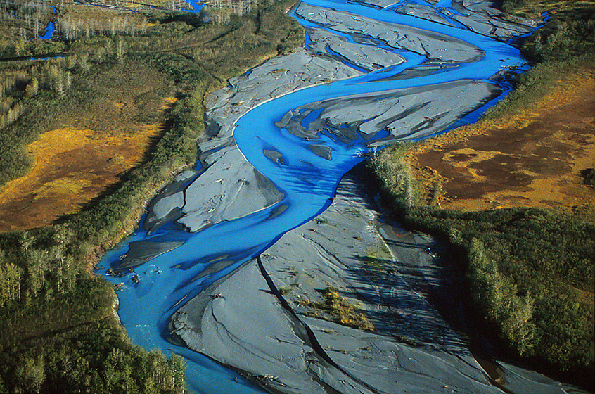
Adventuring on the Yakutat Forelands - Bowing before St. Elias, #33:
The Yakutat Forelands, #33: It is getting dark, we are definitely a little looney, and thus I have a looney idea that seems to make sense. The brush we fought through climbing up here is horrifically dense, and laden with spiny Devil’s Club which we will NEVER see going down in the dark. Our best solution is to get down as quickly as possible, while touching as little as possible. I suggest we put on all our gear, including glove layers, then pull up our rain-hoodies and tie them in place, and simply plunge into the ravine of brush. I believe it is so dense that we will not “fall” through into the ravine, but rather just thrash around in it, while we slide downhill through it. My suggestion is met with some hysterical laughter, UNTIL they realize I am COMPLETELY SERIOUS, and offer to be living proof the idea works, by collecting my cameras tightly around me and plunging. In the bush is like a being on a soggy mat that is trying to suck you down into the undergrowth, but if you wriggle and thrash, you move more forward and downhill, than down into the depths of the ravine. In a matter of minutes I am standing at the base of the knoll, in close walking distance to the cabin, and those that were previously skeptical above can be heard now thrashing in the bushes. Back in the warm cabin, we are exhausted and sleep well during the night, hoping the weather holds and makes our airplane pick-up in the morning effortless. The day does dawn radiantly clear, we rise and pack, and like beautiful clockwork, Mike Ivers, our pilot, appears in the sky above. With little sidewind, the landing is simple, and in a very short amount of time, we are airborne again. Flying off Tanis Mesa and headed back to Yakutat takes us directly over the Alsek-Tatshenshini river system, and down below, hidden in the trees, is the 1st cabin we stayed in when we began this adventure onto the Forelands. It has been a MOST ENLIGHTENING 10 days! Now Yakutat is going to offer us a very different kind of “excitement."
photograph(s) © copyright, Robert Glenn Ketchum, 2017, @RbtGlennKetchum, @LittleBearProd #LittleBearProd
Follow Robert Glenn Ketchum's Photographic Activism Online:
WEBSITE: http://www.robertglennketchum.com/
PINTEREST: http://www.pinterest.com/littlebearprod/
SOCIAL MEDIA by #LittleBearProd: http://www.LittleBearProd.com
Wednesday, August 16, 2017

Adventuring on the Yakutat Forelands - Bowing before St. Elias, #32:
The Yakutat Forelands, #32: As the last light fades and the air grows colder, we all realize what a workout the day has been because we are stiff from sitting, AND we still have one more “adventure” before we can return to the cabin - we have to get down the hill to it in the darkening twilight. I would like to thank Carey, for this picture of me taking one last look. As we are putting on our gear for the descent, I would also like to note and thank Patagonia who supplied me with much of the “new”gear I am sporting. The blue fleece is a 1st generation; the red rain pants, are the 2nd generation of that gear; and the striped, Capilene, expedition, zipper-T-neck has just been introduced, and is my FAVORITE piece of equipment. In Alaska, especially, it stays light and warm when wet, it is self-drying, and it easily ventilates to adjust to activity. Just FYI, the beaded belt holds a lens and case, and the yellow bandana is tied to the drawstring of my rainpants, so I can wipe my cameras off easily. Another sign of the times lies just above the Bandana on my head. I am sporting a curly-top mohawk. I am shaved shear, on the sides, but it is REALLY long on top and in back. For those who mock we with curly hair, THIS is excellent mosquito/biting fly protection - LOL.
photograph(s) © copyright, Carey D. Peterson, 2017, @LittleBearProd #LittleBearProd
Follow Robert Glenn Ketchum's Photographic Activism Online:
WEBSITE: http://www.robertglennketchum.com/
PINTEREST: http://www.pinterest.com/littlebearprod/
SOCIAL MEDIA by #LittleBearProd: http://www.LittleBearProd.com
Wednesday, August 9, 2017

Adventuring on the Yakutat Forelands - Bowing before St. Elias, #31:
The Yakutat Forelands, #31: How big is BIG? Having seen both Mount Fairweather and Denali several times, I can tell you the stunning thing about these mountains is their sheer scale. They are SO much bigger than the big mountains around them. Fairweather is 15,325 feet high, making it one of the tallest coastal mountains IN THE WORLD, and with the setting sun burning off the last clouds of the clearing weather, we get a late evening “peak show,” watching the line of last light crawl slowly to the summit. Did I mention Fairweather is often visible less than 40 days of the year? How is it possible that everything since post #10 of this blog HAS ALL HAPPENED ON THE SAME DAY!!! And now, the sun is setting, and Mark, Carey, and I are still up some trail-less, brush covered hillside referred to as the “moose knoll,” making strange noises at each other and watching all this take place. The day has been a most unusual journey to this point, and none of us sees any reason to change that now. Stay to the end. Go back down to the cabin in the twilight. Sit down, have some snacks, and enjoy the view. Very likely, we will never be here again!
photograph(s) © copyright, ROBERT GLENN KETCHUM, 2017, @RbtGlennKetchum @LittleBearProd #LittleBearProd
Follow Robert Glenn Ketchum's Photographic Activism Online:
WEBSITE: http://www.robertglennketchum.com/
PINTEREST: http://www.pinterest.com/littlebearprod/
SOCIAL MEDIA by #LittleBearProd: http://www.LittleBearProd.com
Wednesday, August 2, 2017

Adventuring on the Yakutat Forelands - Bowing before St. Elias, #30:
The Yakutat Forelands, #30: While I am clicking away in a due westerly direction, I hear Mark to the left of my knoll, mutter “Oh my God, it is going to lift off,” so I turn to see what he is talking about, and find an ever-larger world emerging as the sky clears. The foothills of Glacier Bay National Park are now appearing, and the taller summits can be glimpsed, occasionally peeking out from under the ceiling of vapor that is quickly vanishing. We are so close to the Brabazon summits, they prevent us from seeing the taller peaks of the St. Elias range directly behind us, but out there somewhere in this view, 15,000ft+, Mount Fairweather is “hiding”. Come out! Come out, wherever you are! Now that IS asking for too much,..and yet as I study the bends in the Alsek to see if I can figure out where Fairweather actually is, the skyshow shifts yet again. Look closely at those distant green mountains. They are big. How much larger could Fairweather be? Maybe it is hidden by those mountains in the same way the larger summits behind us are. OR, MAYBE NOT!
photograph(s) © copyright, ROBERT GLENN KETCHUM, 2017, @RbtGlennKetchum @LittleBearProd #LittleBearProd
Follow Robert Glenn Ketchum's Photographic Activism Online:
WEBSITE: http://www.robertglennketchum.com/
PINTEREST: http://www.pinterest.com/littlebearprod/
SOCIAL MEDIA by #LittleBearProd: http://www.LittleBearProd.com
Wednesday, July 26, 2017

Adventuring on the Yakutat Forelands - Bowing before St. Elias, #29:
The Yakutat Forelands, #29: As the minutes pass by, the sky grows increasingly clear. The Yakutat Forelands spread out before us all the way to the shores of the Pacific (far to the right). Aglow in this Alaskan twilight, the meadows roll off like fields of gold, punctuated by kettle ponds and various clusters of trees. Those are the same trees we were wandering around in at the beginning of this trip, when we stopped at our first cabin near the Alsek-Tatshenshini River. That IS the Alsek that you can see coming in from the left in this image, and winding its way to the coast. It is a VERY different view of things we have from up here. Beyond the Alsek, out of this frame to the left, are the numerous snow-capped summits of Glacier Bay National Park and Preserve, which are still engulfed in the clouds of passing weather. That weather is coming from the west, off of the Pacific and blowing eastward, inland. There is always the chance that the clearing sky above us and the ocean, might clear from those summits as well, but after a day like today, perhaps that is asking too much. OR NOT!
photograph(s) © copyright, ROBERT GLENN KETCHUM, 2017, @RbtGlennKetchum @LittleBearProd #LittleBearProd
Follow Robert Glenn Ketchum's Photographic Activism Online:
WEBSITE: http://www.robertglennketchum.com/
PINTEREST: http://www.pinterest.com/littlebearprod/
SOCIAL MEDIA by #LittleBearProd: http://www.LittleBearProd.com
Wednesday, July 19, 2017

Adventuring on the Yakutat Forelands - Bowing before St. Elias, #28:
The Yakutat Forelands, #28: The angle of the setting sun at this ridiculous hour of the night (probably around 11pm) is causing the fall-colored forelands, radiate with a golden glow. I can also see what our pilot, Mike Ivers, meant when he called this a ”moose hunter’s knoll.” From this vantage point, and with clear weather such as we are starting to have, you can view quite a vast expanse of the forelands, and you certainly would notice anything moving around. Immediately below our knoll is an especially “attractive” area for moose because there is a lot of browse and numerous kettle ponds for water and wading. The three of us fall silent (except for the click of my shutter), as the rich tones seem to intensify with every minute the sun drops lower on the horizon. I suspect Mark and Carey are also trying to wrap their minds around all of the things that have happened to us during this amazing day. I certainly am.
photograph(s) © copyright, ROBERT GLENN KETCHUM, 2017, @RbtGlennKetchum @LittleBearProd #LittleBearProd
Follow Robert Glenn Ketchum's Photographic Activism Online:
WEBSITE: http://www.robertglennketchum.com/
PINTEREST: http://www.pinterest.com/littlebearprod/
SOCIAL MEDIA by #LittleBearProd: http://www.LittleBearProd.com
Wednesday, July 12, 2017

Adventuring on the Yakutat Forelands - Bowing before St. Elias, #27:
The Yakutat Forelands, #27: On “her” knoll, Carey is back in the snack bag, and that funny grin has appeared upon her face once again. Her cheeks are going to be sore when she wakes up in the morning because she has been smiling like this all day. Mark is grazing on “his” knoll off to the right. I can hear the occasional sound of a breaking wave carried to me on the breeze, but I have my back to the Pacific and I am chasing the lightshow across the Brabazons as they emerge from the shroud of weather that has been with us for nearly one week. As I watch the warm light crawl upslope with the setting sun, I mutter something out loud about “I am starting to loose my window,” to which Mark and Carey start laughing, and suggest I should turn around and step up to the knoll slightly above me. “Suggestions to travel are dancing lessons from god,” and I do not have to travel very far.
photograph(s) © copyright, ROBERT GLENN KETCHUM, 2017, @RbtGlennKetchum @LittleBearProd #LittleBearProd
Follow Robert Glenn Ketchum's Photographic Activism Online:
WEBSITE: http://www.robertglennketchum.com/
PINTEREST: http://www.pinterest.com/littlebearprod/
SOCIAL MEDIA by #LittleBearProd: http://www.LittleBearProd.com
Wednesday, July 5, 2017

Adventuring on the Yakutat Forelands - Bowing before St. Elias, #26:
The Yakutat Forelands, #26: Carey, Mark, and I protect ourselves while slithering up the steep ravine by donning full rain gear (with hood up), and gloves, and trying to crawl beneath the Devil’s Club’s evil thorny leaves and branches. It takes a good bit of work and we get sweaty hot, all sealed up in our raingear. However, when we finally “summit,” there is a breeze from the ocean and everyone tries to find a brushless place to stand a shed some clothing. I am in a frenzy because this is happening (above), so I am not only thrashing to get out of my steamy gear, but I am trying to get my cameras out and my lens array placed somewhere that can be easily reached. Amidst the brush, there are some small rocky knolls, so each of us stakes out an area and settles in. The low light is beneath the remnants of the weather’s passing clouds, and lighting up the Brabazon Range. Warning! Black hole for film approaching! Always carrying enough film, and NOT using it all before the last days of any trip is a judgement game - you would never want to go home with a lot of unshot film and WISH you HAD taken more pictures of particular moments that you missed, worried you might run short. At the same time, you do not want to use all your film and then have a day like this occur at the end of the trip. The gods are apparently kind to me, and I still have a decent stash, so now I am just working myself into a frenzy. What the hell! It IS our last night on the forelands. Time to party!
photograph(s) © copyright, ROBERT GLENN KETCHUM, 2017, @RbtGlennKetchum @LittleBearProd #LittleBearProd
Follow Robert Glenn Ketchum's Photographic Activism Online:
WEBSITE: http://www.robertglennketchum.com/
PINTEREST: http://www.pinterest.com/littlebearprod/
SOCIAL MEDIA by #LittleBearProd: http://www.LittleBearProd.com
Wednesday, June 28, 2017

Adventuring on the Yakutat Forelands - Bowing before St. Elias, #25:
The Yakutat Forelands, #25: We have been out most all of the day... and an AMAZING day it has been. Back in the cabin we are still pretty “amazed,” however we are also cold and hungry. It's late summer / early fall, and although the days are growing shorter quickly, it is still light until quite late. After a big meal and two hours of a rousing fire in the stove, we are dry, warm, well fed, and completely buzzed by the walk-about of the last 10-hours. No one feels like sleeping as yet, so we all step outside in the cooling air of the evening to realize the storm that has been upon us since we arrived, is breaking off. Big patches of blue sky are appearing over the hill that hides the view of the Pacific, and for the first time, the sun is illuminating some of the lesser summits in the St. Elias range, that are now appearing from behind the Brabizon Mountains. The light is BEAUTIFUL and sets off a lot of braying among us. Mark reminds us that our pilot said the view of the forelands and the Pacific were spectacular from the “moose knoll”, a rounded brushy dome, directly up the hill behind the cabin. At first, adventuring back out into the coming night seems an uncertain idea, but the light show just keeps getting better, so we put our gear back on, grab the cameras and some snacks, and begin searching for a trail. In the diminishing light, the best we can find is a Devil’s Club-choked ravine that is so steep we can lay down beneath the spiky branches and crawl upslope. When this little military exercise finally ends, we find ourselves on another meadow-crown. Not the same ( posts #15-23) but certainly as COSMIC. What a great f*%#ing day!!!
photograph(s) © copyright, ROBERT GLENN KETCHUM, 2017, @RbtGlennKetchum @LittleBearProd #LittleBearProd
Follow Robert Glenn Ketchum's Photographic Activism Online:
WEBSITE: http://www.robertglennketchum.com/
PINTEREST: http://www.pinterest.com/littlebearprod/
SOCIAL MEDIA by #LittleBearProd: http://www.LittleBearProd.com
Wednesday, June 21, 2017

Adventuring on the Yakutat Forelands - Bowing before St. Elias, #24:
The Yakutat Forelands, #24: Navigating is simply a matter of keeping the foothills on our left side, and we can see them even through the dense brush surrounds us. Surprisingly, after a short distance of thrashing, we find this - a dry finger of the river, lavishly overgrown with mosses. Having explored much of this terrain in previous days, we are amazed that we have not previously seen this. It becomes yet another “discovery” of this most unusual outing. It is also a brushless highway that heads in exactly the direction we want to be going. When it finally peters out, we make a sharp right turn, plunge through about a 1/4-mile of bush, and walk out into the middle of the dirt airstrip. It is about 5pm. The cabin is close by, and food, fire, and being dry seem like a really good idea.
photograph(s) © copyright, ROBERT GLENN KETCHUM, 2017, @RbtGlennKetchum @LittleBearProd #LittleBearProd
Follow Robert Glenn Ketchum's Photographic Activism Online:
WEBSITE: http://www.robertglennketchum.com/
PINTEREST: http://www.pinterest.com/littlebearprod/
SOCIAL MEDIA by #LittleBearProd: http://www.LittleBearProd.com
Wednesday, June 14, 2017

Adventuring on the Yakutat Forelands - Bowing before St. Elias, #23:
The Yakutat Forelands, #23: Cryptic messages written in the lichen deciphered, perimeter surveyed and secured, blueberries consumed, grazing goats observed - what a world! For awhile the light rain abates and the clouds lift, revealing the taller, rock summits above the foothills. The three of us just stand in silence trying to drink it in. The sound of water is everywhere. Countless waterfalls stream down into the meadows from snowfields above. It is so lush, so verdant, SO wild! It is also getting late in the day, so we collect ourselves (and our thoughts) and tip-toe back through the rock gardens to the series of ledges we climbed to get here. As soon as we drop below the curve of the dome, the spectacle of fall vegetation ceases, and we return to the greens of the bush and the forest. The downclimb is relatively easy, and delivers us next to the blue pool and waterfall (post #15) to which our incoming forest trail led us before we climbed into the meadow. Interestingly, only the pool and waterfall look the same, and although we explore all around us in the trees, the small path we came in on, is not to be found. We know where the cabin is and which way we should head, but it just seems very strange that we cannot find the path.
photograph(s) © copyright, ROBERT GLENN KETCHUM, 2017, @RbtGlennKetchum @LittleBearProd #LittleBearProd
Follow Robert Glenn Ketchum's Photographic Activism Online:
WEBSITE: http://www.robertglennketchum.com/
PINTEREST: http://www.pinterest.com/littlebearprod/
SOCIAL MEDIA by #LittleBearProd: http://www.LittleBearProd.com
Wednesday, June 7, 2017

Adventuring on the Yakutat Forelands - Bowing before St. Elias, #22:
The Yakutat Forelands, #22: Carey still has “that” grin on her face, and Mark has now decided to investigate the perimeter of this “life form” we have been grazing around (we are definitely stuffed with blueberries - LOL). Interestingly, Mark is literally standing at the edge of the meadow “cap-of-color” we have found, and beyond him, the vegetation becomes a dense, overhead thrash, the green of which you can see welling up. This is also a great place to make note of the view: we are in the foothills of the Brabazon Mountains, and they rise to the left; through the “gap” on the horizon, you can see a flash of blue from the Alsek-Tatshenshini River; THEN, rising to the right is the ridge above our cabin. If you look carefully at the low, gap-end of the ridge where it begins to rise, the first small bump above the horizon is another location our pilot, Mike Ivers, has said we should visit as it affords a great view out over the forelands. None of us know it at this moment, but we WILL watch a cosmic sunset from that knoll before we leave - Oh!, In fact, later tonight. Much later tonight.
photograph(s) © copyright, ROBERT GLENN KETCHUM, 2017, @RbtGlennKetchum @LittleBearProd #LittleBearProd
Follow Robert Glenn Ketchum's Photographic Activism Online:
WEBSITE: http://www.robertglennketchum.com/
PINTEREST: http://www.pinterest.com/littlebearprod/
SOCIAL MEDIA by #LittleBearProd: http://www.LittleBearProd.com
Wednesday, May 31, 2017

Adventuring on the Yakutat Forelands - Bowing before St. Elias, #21:
The Yakutat Forelands, #21: Once I work my way over to Mark, trying not to crush any lifeforms in this strange meadow, I can see what has inspired his babbling. Where he is standing, the brilliant fall foliage that is slowly taking over this rock outcrop has not quite completed its task, and you can see that beneath the canopy of grasses and moss, are black, wet rocks that even look volcanic. There was probably a pond here at some point that is now gone, and what is left is being overgrown by the creep of vegetation. The longer I stare down at this, however, the more I begin to see it as Mark does. The black rocks become a kind of deep space, and they recede, leaving the radiant meadow cover to seemingly “float” above the black “space” like some kind of Persian flying carpet. After that little revelation, I glance over at Mark, who clearly knows what I have just seen, and he says, “Be careful not to step into one of those black holes. You’ll be gone and we will never find you."
photograph(s) © copyright, ROBERT GLENN KETCHUM, 2017, @RbtGlennKetchum @LittleBearProd #LittleBearProd
Follow Robert Glenn Ketchum's Photographic Activism Online:
WEBSITE: http://www.robertglennketchum.com/
PINTEREST: http://www.pinterest.com/littlebearprod/
SOCIAL MEDIA by #LittleBearProd: http://www.LittleBearProd.com
Wednesday, May 24, 2017

Adventuring on the Yakutat Forelands - Bowing before St. Elias, #20:
The Yakutat Forelands, #20: Just as I feared, Mark has now folded into a position that allows him to read the words written on the rock by the lichen. He is telling me what they say but neither Carey, nor I, can understand HIM, so we are not really learning much. It IS amusing, however, and we start laughing. Mark assures us that “there is nothing funny about this," but at the moment, it is all TOO funny for us to be concerned. Then, just as I predicted (and fear), Mark drops to all four and begins grazing on blueberries. Apparently they give him clarity of speech once again, and he babbles something about how I “must” take pictures of the cosmic mud he has discovered. Therein may be the answer as to why this meadow is here - it is made of cosmic mud, and these are alien life forms that exist ONLY here. Pondering that theory, I tip-toe carefully over to Mark and help him regain an upright position, so that he may reveal to me his discovery. I am relieved he has not begun rubbing it on his face for camo. The goats REALLY think we are a funny group.
photograph(s) © copyright, ROBERT GLENN KETCHUM, 2017, @RbtGlennKetchum @LittleBearProd #LittleBearProd
Follow Robert Glenn Ketchum's Photographic Activism Online:
WEBSITE: http://www.robertglennketchum.com/
PINTEREST: http://www.pinterest.com/littlebearprod/
SOCIAL MEDIA by #LittleBearProd: http://www.LittleBearProd.com
Wednesday, May 17, 2017

Adventuring on the Yakutat Forelands - Bowing before St. Elias, #19:
The Yakutat Forelands, #19: Packs off. Snacks underway. Why does Carey have that ridiculous grin on her face? Where are we? What the f%*# has happened to this meadow? Why is that family of mountain goats laughing at us? Who put the perfect jewel water droplets on every leaf? Why is everything around us all of these funny colors, when nothing else anywhere near us looks like this? So many questions, so few answers. Uh, oh! It looks like Mark is being sucked into a nose dive. If he gets down on his knees and starts to graze, we will be here all night. This is clearly a dangerous situation and I am trying to get Carey to “wave him off,” but she is too busy giggling to respond and just keeps muttering, “What IS this place?” Like I know!?!
photograph(s) © copyright, ROBERT GLENN KETCHUM, 2017, @RbtGlennKetchum @LittleBearProd #LittleBearProd
Follow Robert Glenn Ketchum's Photographic Activism Online:
WEBSITE: http://www.robertglennketchum.com/
PINTEREST: http://www.pinterest.com/littlebearprod/
SOCIAL MEDIA by #LittleBearProd: http://www.LittleBearProd.com
Wednesday, May 10, 2017

Adventuring on the Yakutat Forelands - Bowing before St. Elias, #18:
The Yakutat Forelands, #18: To give you some sense of this little “stone"-dome, meadow garden we have found in the rain at Tanis Mesa, this shot is of my then-wife, Carey, navigating a thin rock ridge between two very different micro-niches. In front of her is a small section of the psychedelic-carpet meadow, and directly behind her is a miniature swamp, complete with cattails. Where the vibrant colors stop and the world turns green, is a steep, brushy cliff, that goes down 50-60ft. into a much bigger, completely flooded swamp. On my side, it plunges down even more steeply to the riverbed below where we have spent most of the day. The goats are amused that we have made it this far, but apparently they are also clear that we are NOT hunters, so they show no inclination to move away. Besides, what IS clear to all of us is that THIS is our destination. It is not their meadow. So, in the steady light rain we unburden ourselves of our packs, have some more snacks, and meander in this stunning moment and place, none of us will ever see again.
photograph(s) © copyright, ROBERT GLENN KETCHUM, 2017, @RbtGlennKetchum @LittleBearProd #LittleBearProd
Follow Robert Glenn Ketchum's Photographic Activism Online:
WEBSITE: http://www.robertglennketchum.com/
PINTEREST: http://www.pinterest.com/littlebearprod/
SOCIAL MEDIA by #LittleBearProd: http://www.LittleBearProd.com
Wednesday, May 3, 2017

Adventuring on the Yakutat Forelands - Bowing before St. Elias, #17:
The Yakutat Forelands, #17: With a few increasingly slippery twists and turns, the rock ledge staircase we are following comes over a low rise and reveals a small, flat-topped “mesa” of rock that has become a combination of meadow and swampy ponds, and is lushly overgrown with mosses, grasses, blueberries, lichen, and other “things" that are ALL covered with beads of rain, causing them to sparkle and glow. I have NEVER been met so enthusiastically by a group of strangers in my life. The three of us are dazzled to say the least. We ARE in a “lost world.” From where we stand, we can now see in all directions and there is NOTHING anywhere else that looks like THIS garden! And, when I say “stand,” I mean we STAND AND STARE. The longer we gaze, the more ridiculous this gets. We all start laughing and grow really stupid grins on our faces. We are also “standing” because we do not want to step on anything, but we do want to move around a bit and get a closer look at this, so very cautiously we work out our individual paths, traversing across whatever exposed stone we can find.
photograph(s) © copyright, ROBERT GLENN KETCHUM, 2017, @RbtGlennKetchum @LittleBearProd #LittleBearProd
Follow Robert Glenn Ketchum's Photographic Activism Online:
WEBSITE: http://www.robertglennketchum.com/
PINTEREST: http://www.pinterest.com/littlebearprod/
SOCIAL MEDIA by #LittleBearProd: http://www.LittleBearProd.com
Wednesday, April 26, 2017

Adventuring on the Yakutat Forelands - Bowing before St. Elias, #16:
The Yakutat Forelands, #16: We have found a virtual staircase leading up through a series of rock ledges. With every step we gain dramatic elevation AND the vegetation starts to change. If you follow this blog, you may have seen the previous posts in which we probed the bluffs looking for a way up into the meadows above, only to no avail. Perhaps you were thinking we should plunge in and start scrambling, but now you have this perspective, study the view. Those bluffs are an impenetrable thicket, and in many places, the faces are sheer, completely vertical. Without this amazing subtle trail our pilot revealed to us, we would never have made this ascent. The view is spectacular. We can see the expanse of the river we have been following, AND off to the right, our cabin sits at the foot of those distant hills. We still have some way to scramble up before we get to the top of our staircase and a light rain is once again beginning to fall, so we press on to see where this is going to lead us.
photograph(s) © copyright, ROBERT GLENN KETCHUM, 2017, @RbtGlennKetchum @LittleBearProd #LittleBearProd
Follow Robert Glenn Ketchum's Photographic Activism Online:
WEBSITE: http://www.robertglennketchum.com/
PINTEREST: http://www.pinterest.com/littlebearprod/
SOCIAL MEDIA by #LittleBearProd: http://www.LittleBearProd.com
Wednesday, April 19, 2017

Adventuring on the Yakutat Forelands - Bowing before St. Elias, #15:
The Yakutat Forelands, #15: Recalling our pilot's parting advice about a small trail at the end of the dirt runway that might provide access to the goat meadows above the headlands, I tell Cary and Mark we should check it out before returning to the cabin, to which they agree. We do a few more small stream fords and some low stick-thrash, then relatively quickly we find ourselves on the dry, brushless strip that serves the precarious landing. We are a good distance from the cabin, and in minutes we reach “the end” of the strip. Visible, but only just barely so, there is clearly a trail in the brush, but it does no appear to have much use. We forge away and see that it runs parallel to the water flows we have engaged all morning, mostly passing through a stand of trees and scrub. At some point in the walk, we cross an invisible line in the forest that COMPLETELY changes our auditory intake. The sound of our footsteps give way to water noises which quickly grow louder, and then just some feet further along, clearly begin a kind of sonic echoing that we all hear in amazement. Mark is concerned we might have consumed to many snacks, but I am sure “it is all good” and continue to decipher the path. It comes to a gnarly rock wall that is covered with astounding lichen, but little vegetation, and there is clearly visible climbing access, so I start up. It is wet and slippery, but GLOWING, and the echoing of the waterfall changes pitch and rhythm as we change our position. At one point we round a small ledge, and look down on the source of our soundtrack. I think we ARE going to goat heaven!
photograph(s) © copyright, ROBERT GLENN KETCHUM, 2017, @RbtGlennKetchum @LittleBearProd #LittleBearProd
Follow Robert Glenn Ketchum's Photographic Activism Online:
WEBSITE: http://www.robertglennketchum.com/
PINTEREST: http://www.pinterest.com/littlebearprod/
SOCIAL MEDIA by #LittleBearProd: http://www.LittleBearProd.com
Wednesday, April 12, 2017

Adventuring on the Yakutat Forelands - Bowing before St. Elias, #14:
The Yakutat Forelands, #14: As we get closer to the rugged, brushy, and increasingly steep hillside, I KNOW we are not getting UP through this unless we find a trail. It is the worst kind of stick-thrash, heavily infused with Devils’ Club. Mark is momentarily of the belief a way can be found, so he and Carey ford the final, larger river and investigate the embankment. This water is faster and deeper and I do not see it worth the effort so I continue to walk upstream along one of the rocky bars parallel to them as they try to find an opening that might allow us up the hillside. Unfortunately, their shoreline and bar finally terminate at a pool far to deep and cold to consider crossing, so now we will backtrack until we can unite. It is a pleasant walk, the intermittent rain helps keep mosquitoes at bay, and the forelands are radiantly beautiful in their water-saturated fall colors with the sparkle of waterdrops on everything. We connect in several hundred yards and decide to head back towards the cabin, but with each step of retreat from the headwall and meadows above, my mind dives into my subconscious and I begin to recall our pilot, Mike Ivers' voice as we were landing: “There is only one way up into those meadows and you will find it by following a small trail at the end of the runaway.” WHAT?
photograph(s) © copyright, ROBERT GLENN KETCHUM, 2017, @RbtGlennKetchum @LittleBearProd #LittleBearProd
Follow Robert Glenn Ketchum's Photographic Activism Online:
WEBSITE: http://www.robertglennketchum.com/
PINTEREST: http://www.pinterest.com/littlebearprod/
SOCIAL MEDIA by #LittleBearProd: http://www.LittleBearProd.com
Wednesday, April 5, 2017

Adventuring on the Yakutat Forelands - Bowing before St. Elias, #13:
The Yakutat Forelands, #13: This is what we / Mark (last post) are looking at across the river. We now realize there are several “fingers” to this glacial river, the first of which we have already crossed, nearest to the cabin. Now we stand at the shore of another, and we are closer to the headwall and the meadows, BUT not there yet. This stream is broader, deeper, and takes some work to find a safe place to ford, but we really want to get up in those meadows where the goats are, so we press ahead. We can see there will be another stream/river before we are finally there, because if you look carefully through the tree branches, you will notice numerous waterfalls streaming down from the meadows and over the headwall. Some of them are quite large. There is a lot of water coming out of these foothills. The goats think we are amusing. We think we are getting up into those meadows where they are. It starts to rain a bit, so we sit on the shore, ponder our purpose, have some snacks, and gear up for our “assault” on the bluffs soon to be before us.
photograph(s) © copyright, ROBERT GLENN KETCHUM, 2017, @RbtGlennKetchum @LittleBearProd #LittleBearProd
Follow Robert Glenn Ketchum's Photographic Activism Online:
WEBSITE: http://www.robertglennketchum.com/
PINTEREST: http://www.pinterest.com/littlebearprod/
SOCIAL MEDIA by #LittleBearProd: http://www.LittleBearProd.com
Wednesday, March 29, 2017

Adventuring on the Yakutat Forelands - Bowing before St. Elias, #12:
The Yakutat Forelands, #12: The “mission” for the day is to get UP into the meadows where we might encounter mountain goats grazing. Food eaten, gun loaded, gear on, and we are out the door. We decide to follow the path to our water stream, cross the stream, and continue on to the next water we can hear. From our POV, it looks like that other river is close to the base of the meadows into which we hope to ascend. The stream we are drinking from is shallow and simple to cross, but after that there is no clear path and progress becomes a bushwhack. The distance is greater than we expect, and the bush becomes denser and taller than we would like, because we are now wandering around in some infamous moose and bear-hunting territory and we can barely see 10ft in any direction. The weather is kind, but the terrain is not, and then suddenly we crash through the thicket onto the stone-strewn banks of a much larger river and the view opens. We are at the foot of the Brabazons looking up into stunning, verdant meadows. Mark felt the need to take off his glasses to affirm what he was seeing. Then, just when we thought it could not get much better, a large group of goats and their kids grazes out into the middle of the greenery, and starts lying about chewing... and watching us.
photograph(s) © copyright, ROBERT GLENN KETCHUM, 2017, @RbtGlennKetchum @LittleBearProd #LittleBearProd
Follow Robert Glenn Ketchum's Photographic Activism Online:
WEBSITE: http://www.robertglennketchum.com/
PINTEREST: http://www.pinterest.com/littlebearprod/
SOCIAL MEDIA by #LittleBearProd: http://www.LittleBearProd.com
Wednesday, March 22, 2017

Adventuring on the Yakutat Forelands - Bowing before St. Elias, #11:
The Yakutat Forelands, #11: There is a party of 4 hunters from Texas already at the Tanis Mesa cabin when we arrive, and they will be flying out with Mike after he drops us. We spoke with them about their hunt as they had no meat hanging, and they explained they had come for goat, and they could scope them EVERY night up in the meadows of the Brabazons, rising above the Mesa to the east, but the goats were VERY far away, and even with a successful long shot, they did not want to kill something they could not retrieve. They admitted they never found a way to get UP into the meadows. They DID say the knoll was a great view. Our gear came out of the plane, and their’s went in, after which Mike Ivers took off, to be back in three days. The cabin is spacious and warms quickly, once we start a fire. It rains on and off, so after getting organized, we eat lunch and go outside for a walk around. We are surrounded by a thick, brushy landscape of shrubs, grasses and a few trees, but there is more forest as we move away from the cabin. The established paths take us from the cabin to the runway, and then from the runway, through the scrub, to the shore of a glacial-melt, azure-blue stream where we will get our drinking water. Beyond that there is more of a forest, and we can hear the sound of larger water. After a water-carry back to the cabin, we chill for the day, and prep daypacks for tomorrow. It continues to rain on-and-off through dinner and into the night, so we eat and sleep well, waking ready to go early the next day.
photograph(s) © copyright, ROBERT GLENN KETCHUM, 2017, @RbtGlennKetchum @LittleBearProd #LittleBearProd
Follow Robert Glenn Ketchum's Photographic Activism Online:
WEBSITE: http://www.robertglennketchum.com/
PINTEREST: http://www.pinterest.com/littlebearprod/
SOCIAL MEDIA by #LittleBearProd: http://www.LittleBearProd.com
Wednesday, March 15, 2017
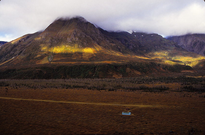
Adventuring on the Yakutat Forelands - Bowing before St. Elias, #10:
The Yakutat Forelands, #10: Morning brought a high ceiling and broken clouds, so we knew our pilot, Mike Ivers, would be on his way to our beach “house” to pick us up and take us to the last location in our exploration of the Yakutat Forelands, Tanis Mesa. Our first stop on this trip was a cabin near the shore of the Alsek-Tatshenshini river, the area of which is overviewed in post #3. Look carefully at that post again now, and you will notice that directly above the “O” shape in the river, at the base of the snow-covered peaks, there is a green, elevated, flat-topped “foothill” leading to the mountains in the Brabazon Range. THAT is Tanis Mesa. In this picture you can see Tanis Mesa cabin; the brown, open shed for hanging game; and the path to the small dirt runway, then the Brabazons rise. This may look like a wide expanse, but that is the effect of the lens. In fact, as Mike was telling us ON APPROACH, this is a really “tricky” place to land, because it is a short runway and there is an unpredictable mix of wind. Turbulence off of the Pacific flows east and UPSLOPE; cold air from the towering, summits of the St. Elias Range flows west, DOWNSLOPE. When and where they collide, is a dangerous zone and that is often over the mesa. BUT, Mike assures us, he flies in here all of the time and today it is “not too bad.” He also notes we should ignore the crash wreckage of two other planes that we will see in the trees at the end of the runway. Again, in these final moments before landing, Mike is throwing out “advice” about what we might expect and want to do. One of those is to summit a knoll near the cabin, a high point used by hunters to scope the terrain (not visible here - beneath the plane). Another is to climb into the meadows of the Brabazons (sunlit in this photograph) where we will get close to mountain goats. Bouncing around a lot from buffeting winds, just as we touch down he mentions getting UP INTO the meadows is tough, and the ONLY access point is a small trail in the trees starting at the END OF THE RUNWAY. We “sort of” hear that, but the wheels hit dirt, we breath some relief, and the work of unloading the plane begins, pushing Mike’s advice to the subliminal corners of our brains.
photograph(s) © copyright, ROBERT GLENN KETCHUM, 2017, @RbtGlennKetchum @LittleBearProd #LittleBearProd
Follow Robert Glenn Ketchum's Photographic Activism Online:
WEBSITE: http://www.robertglennketchum.com/
PINTEREST: http://www.pinterest.com/littlebearprod/
SOCIAL MEDIA by #LittleBearProd: http://www.LittleBearProd.com
Wednesday, March 8, 2017

Adventuring on the Yakutat Forelands - Bowing before St. Elias, #9:
The Yakutat Forelands, #9: It stormed all night and into the morning, so no one was in too much of a hurry to get out of their sleeping bags. Because of the unrelenting weather, it also remained dark and dreary. Hanging by the fire and keeping it well stoked became a pastime. This was supposed to be the day our pilot, Mike Ivers, thought the weather would break, but that did not appear to be the case at the moment. Somewhere around noon, the rain and wind ceased yet again, but this time when we looked out, you could actually see blue sky and some sunshine. Even though we had gone in and out all morning for some short excursions, we all had cabin fever and wanted to do something more adventurous, so we immediately threw together our daypacks and snacks, donned gear, and headed out the door, due west. The Pacific shore or bust! Do you recall in post #6, I closed by saying, “It is a BIG beach!” Well, THAT was prescient. We walk and we wander. We stare. We collect “stuff.” The cabin disappears from view. The berms begin to disappear. Who knew you might need a compass/GPS on a beach! We can always follow our own tracks home, as long as it does not rain or get windy - LOL! We can hear the Pacific and see the horizon, but the actual shore is still a good distance. As it tuns out, experienced hunters on the forelands come here with ATV’s to get around. I get it! Slowly the evening skyshow begins, so we terminate our destination march, and hunker down out of the breeze behind some logs to watch the sunset unfold. There were some moments, like this, when long, golden rays would break through and light up the landscape, but the horizon remained cloudy so there was no sunset spectacle to be had, and once we saw the descending twilight start, it was time to find the cabin, eat some food, and get organized for a promised plane pick-up in the morning that would take us to our third forelands destination, Tanis Mesa.
photograph(s) © copyright, ROBERT GLENN KETCHUM, 2017, @RbtGlennKetchum @LittleBearProd #LittleBearProd
Follow Robert Glenn Ketchum's Photographic Activism Online:
WEBSITE: http://www.robertglennketchum.com/
PINTEREST: http://www.pinterest.com/littlebearprod/
SOCIAL MEDIA by #LittleBearProd: http://www.LittleBearProd.com
Wednesday, March 1, 2017

Adventuring on the Yakutat Forelands - Bowing before St. Elias, #8:
The Yakutat Forelands, #8: With long Alaskan twilights, we did not want to have our actual dinner too early, but by waiting out bad weather burst, we clearly over-snacked and needed to go back outside and walk around some more, so the gods provided. Following our now-often-repeated ritual of donning the fleece, rain-gear, and knee-high rubber boots, we opened the cabin door to find a clearly defined line of passage through the grasses just behind the cabin and bare sand spots sporting large bear prints. We reasoned that we should go in the exact opposite direction as quickly as possible, and so we headed out onto the expanse of the beach and began a walk toward the Pacific shore. As our pilot, Mike Ivers, pointed out, "at least out here you can see the bear coming.” Unfortunately, you could also see that if a bear WAS coming, there was certainly no place for you to go. With that happy thought in mind, we wandered on. The sand was firm, so walking was not difficult, and the further we got from the cabin and our berm, the less and less vegetation there was. We have now entered the twilight (zone), and the sky is illuminated and bright, but the sun has gone down. The wet beach looks almost like the black sand in Hawaii, but the landscape still has color and we can see clearly in all directions. The rain and wind have mercifully stopped, and it is actually eerily silent. Then, all of us notice this at once. Hard not to. For the three of us, it was as if someone turned on a light inside of it. This is one of my favorite Cibachrome prints, because the 3-dimensionality of the print REALLY makes this float and glow like it was that evening. This is, “Luminous Drift Log, Yakutat.” The weathered, water polished log has become a mirror to the light of the bright evening sky, but I am not sure we knew that at the moment of this picture. Soon thereafter, it grew dark more quickly, so we beat our retreat to the cabin. We never made the Pacific shore, so that would be tomorrow’s destination.
photograph(s) © copyright, ROBERT GLENN KETCHUM, 2017, @RbtGlennKetchum @LittleBearProd #LittleBearProd
Follow Robert Glenn Ketchum's Photographic Activism Online:
WEBSITE: http://www.robertglennketchum.com/
PINTEREST: http://www.pinterest.com/littlebearprod/
SOCIAL MEDIA by #LittleBearProd: http://www.LittleBearProd.com
Wednesday, February 22, 2017

Adventuring on the Yakutat Forelands - Bowing before St. Elias, #7:
The Yakutat Forelands, #7: As Mike Iver’s plane plane passed out of site into the clouds, the weather closed down on us. A hard, cold rain started and the wind was picking up - all great reasons to retire to our cabin, stow our gear, and have some HOT food. Throughout a long, leisurely lunch and snacks, the rain continued to pound down in weird rhythms on the roof, and howling gusts coming in off the Pacific would make strange noises, rattling the cabin and causing high-pitched drone tones to echo from the corners. Regularly, we would imagine hearing a bear, but upon investigating, never found prints or saw one - I think it was just cabin-restlessness, and we needed to go out for a walk. Late in the afternoon, the storm momentarily let up, so we took the opportunity to explore our new environment. The cabin is a long way up a HUGE beach that is not only VERY wide, looking north and south, you can not see either end. We are backed against a berm island of dense vegetation that includes small trees. Because of saltwater intrusion, there is a distinct line where the trees stop and a grassy, vine-y beach habitat begins. Everything is wet. The grass is knee-deep and glistening. It sways in mesmerizing patterns as the gusts sweep across it. There is a river a short distance away that is our water source, so we walk there first, but tidal mud on the river bank shows REALLY BIG fresh bear tracks, and this is a bit offsetting. We have not come that far in the scope of this vast expanse of beach, dunes, and berms but as we look around hoping NOT to see a bear, it becomes clear how small the cabin is. Just as we finish drawing water, the rain starts once again, and by the time we forge our way back though the grasses, it is blowing sideways. Time to re-stoke the stove fire, get out the snacks, and hang on! Here we go again.
photograph(s) © copyright, ROBERT GLENN KETCHUM, 2017, @RbtGlennKetchum @LittleBearProd #LittleBearProd
Follow Robert Glenn Ketchum's Photographic Activism Online:
WEBSITE: http://www.robertglennketchum.com/
PINTEREST: http://www.pinterest.com/littlebearprod/
SOCIAL MEDIA by #LittleBearProd: http://www.LittleBearProd.com
Wednesday, February 15, 2017

Adventuring on the Yakutat Forelands - Bowing before St. Elias, #6:
The Yakutat Forelands, #6: After two days of “blazing” hot weather and a horrible storm of biting insects, I could hear rainfall start on the roof of our cabin about midnight. Rainfall is a “modest” use of the word. Remember, our cabin is in the forelands facing the Gulf of Alaska, and at the foot of Mt. St. Elias, thus we are probably part of one of the greatest weather generating system on earth, next to the Himalayas. When we awoke, it was pouring and the ceiling was low, but having flown with Alaskan pilots, I knew if Mike could get through, he would. Dutifully we packed our gear and waited. Sure enough, about 10am there was a break in the weather and Mike immediately appeared overhead and circled. We loaded as soon as he landed and were off to the coast. Because of the low ceiling, Mike flew just above the beach which gave us a great look at the miles and miles of Pacific shoreline that define the western face of the forelands. Several cabins could be seen along our flight path, but Mike was taking us to one near a river complex because we might SEE MORE BEAR THERE! Once again, Mike also handed out some brief but useful information as we approached our destination. Our cabin is in the treeline where the fog and beach meet (upper, middle). Mike noted it would be easier to get around here because there were fisherman trails (lower, left side, in the scrub) along the river, BUT it would also be “spooky” because much of the vegetation was dense, overhead, and there were a lot of bears. Mike said he preferred being on the beach because "at least that way he could see them coming from a good distance." Lastly, he said he felt we would like the beach because we would never see another so large, wild, and untrammeled, AND if the weather report he heard was right, this storm would break off in one day and it would be glorious out along the coast. With that we arrive, landing on the beach and literally taxiing to the cabin. It is raining hard. It is blowing and cold. There are a lot of bear prints in the sand. Mike says he HOPES he will see us in two days (little Alaskan joke), and then he disappears into the clouds. It IS a big beach!
photograph(s) © copyright, ROBERT GLENN KETCHUM, 2017, @RbtGlennKetchum @LittleBearProd #LittleBearProd
Follow Robert Glenn Ketchum's Photographic Activism Online:
WEBSITE: http://www.robertglennketchum.com/
PINTEREST: http://www.pinterest.com/littlebearprod/
SOCIAL MEDIA by #LittleBearProd: http://www.LittleBearProd.com
Wednesday, February 8, 2017

Adventuring on the Yakutat Forelands - Bowing before St. Elias, #5:
The Yakutat Forelands, #5: We had come to this cabin on the Yakutat forelands ostensibly to see the coastal terrain of the Tatsheshini-Alsek river flowing to the Pacific from Canada. It is a huge river system whose headwaters involve three national parks and the largest designated wilderness in the world - Tatshenshini. After our plane dropped us and we got our Forest Service cabin squared away, we loaded our daypacks and decided to explore. We thought we would walk to the river, but as we moved further from the cabin, knowing where it was and where we were became an increasing challenge. It was also REALLY HOT. Midday, temperature was easily in the 80’s which for Alaska, is quite toasty, and it made the insect population not only active, but overwhelming. After some hours of wandering through swampy meadows and groves of trees, we were grateful NOT to have encountered moose or bear, and we felt we had a better understanding of how to get around. We were also VERY tired of the bugs, so we returned to the cabin for dinner and an early bed. The next day was a dawn rising so we could get moving before the insects, and we intended to reach the river this time. The good news is that we did. More good news is that out here on the gravel bar of one of the huge river braids, the breeze and lack of cover vegetation has GREATLY reduced the insect population. Mark, Carey, and I finally have some relief from, not only mosquitoes, but a frenzy of biting flies. It is still hot, and now that we have done all of this work, this is my new POV. See the river? The sliver line of blue to the right is the Alsek. The thin line of blue behind Mark is Alsek Lake, and the tall, pyramid-shaped peak to the right, is Mt. Fairweather in Glacier Bay National Park and Preserve to our south. As “nice” a day as this was, we all agreed we were glad Mike would pick us up in the morning and move us to the forelands beach.
photograph(s) © copyright, ROBERT GLENN KETCHUM, 2017, @RbtGlennKetchum @LittleBearProd #LittleBearProd
Follow Robert Glenn Ketchum's Photographic Activism Online:
WEBSITE: http://www.robertglennketchum.com/
PINTEREST: http://www.pinterest.com/littlebearprod/
SOCIAL MEDIA by #LittleBearProd: http://www.LittleBearProd.com
Wednesday, February 1, 2017

Adventuring on the Yakutat Forelands - Bowing before St. Elias, #4:
The Yakutat Forelands, #4: Most of the flying I did in Southeast (AK) to various destinations in the Tongass rainforest were done in float planes that land on water. Even access to the high country involved landing on mountain lakes. Here on the forelands, however, there were wide expanses of hard ground, so small runways had been created next to US Forest Service cabin locations, or you landed on the beach in a wheeled plane. As our pilot, Mike Ivers, circled the small airstrip next to the cabin we were going to use, he explained the logic of the tour he helped plan for us. Our first stop was this cabin near to the Alsek River. He thought we would find this location the least productive and most difficult to accomplish much in, because the scale of the landscape was so large. He felt once on the ground, changing my viewpoint would be hard to do. He was also concerned that we read topo maps BUT did not have a compass/GPS. He thought if we wandered too far, we might not find the cabin again because, once you walked away from it, it became nearly invisible in the greater landscape. As a consequence, this would be our shortest stay and he would move us to a beach cabin in two days. He finished this discourse as we landed, so we were listening to him, but perhaps not fully aware of what his words meant. After unloading, Mike wished us well, and as you can see, off he went. The cabin was quite nice, but this picture makes clear why Mike was concerned my point of view would not change much. It would pretty much always look like this.
photograph(s) © copyright, ROBERT GLENN KETCHUM, 2017, @RbtGlennKetchum @LittleBearProd #LittleBearProd
Follow Robert Glenn Ketchum's Photographic Activism Online:
WEBSITE: http://www.robertglennketchum.com/
PINTEREST: http://www.pinterest.com/littlebearprod/
SOCIAL MEDIA by #LittleBearProd: http://www.LittleBearProd.com
Wednesday, January 25, 2017

Adventuring on the Yakutat Forelands - Bowing before St. Elias, #3:
The Yakutat Forelands, #3: To wit! To woo! And So much to do! Yeh, and SO MUCH space to do it in. I came to Yakutat the first time with my wife, Carey, and one of my best friends from college, Mark Thompson. Moving all our gear and my cameras around, 3 people are always better than 2, AND Mark was armed. I wanted to photograph the Forelands both from the air and on the ground, and to do either of those things I would need to fly. The pilot best known in the area, and the one I had been told to contact was (Iron) Mike Ivers, and Mike proved to be not only a dependable pilot, but someone who offered many tidbits of advice, IF YOU WERE LISTENING! When we met Mike and I first described my project, he suggested a multi-day “loop” trip that would visit three different locations, in every instance utilizing US Forest Service cabins. He assured us we would be better off in cabins than tents because of the many moose and bear that might be encountered. The plan sounded good to us, so we were off to the first location, near to the shore of the Alsek-Tatshenshini River and on the flattest part of the Foreland plain. In this picture, lines of mostly deciduous trees wind through meadows and swampy areas, as the Alsek flows right to left, toward the Pacific. St. Elias is in the distance, and just adjacent the big “O”- shaped braid in the river (near center of pic) there is a cabin in the treeline and a dirt runway cut into the large meadow behind it. This will be our first stop.
photograph(s) © copyright, ROBERT GLENN KETCHUM, 2017, @RbtGlennKetchum @LittleBearProd #LittleBearProd
Follow Robert Glenn Ketchum's Photographic Activism Online:
WEBSITE: http://www.robertglennketchum.com/
PINTEREST: http://www.pinterest.com/littlebearprod/
SOCIAL MEDIA by #LittleBearProd: http://www.LittleBearProd.com
Wednesday, January 18, 2017

Adventuring on the Yakutat Forelands - Bowing before St. Elias, #2:
The Yakutat Forelands, #2: Yakutat is a small community of less than 700 people, but interestingly in the vast scale of Alaska, it is one of the largest counties in the US. The city sits at the mouth of Yakutat Bay, a relatively protected harbor, surrounded by Forelands and at the foot of the massive coastal range. At the deepest point of the bay, it connects to Russell Fjord and the Hubbard Glacier, America’s largest tidewater glacier. As the Forelands spread north of Yakutat, you truly enter a world of Alaskan superlatives: the first encounter is the spreading braids of the massive Alsek-Tatshenshini River flowing out of Canada to the Pacific; then comes the Malaspina, the largest piedmont glacier IN THE WORLD. Now in significant retreat, the Malaspina was 1,500-square-miles in size at one point, and THIS is an amazing thing to fly above; just past that (and visible here) is Icy Bay, another large bay like Yakutat, but created quite recently by epic glacial retreat (it is now 30-miles deep); and lastly, Icy Bay brings you directly to the foot of Mount St. Elias, at 18,008ft, the second tallest summit in North America, AND the greatest vertical rise from sea level in the world. The massif of St. Elias also defines the western boundary of Wrangell-St.Elias National Park and Preserve which includes the Malaspina and Hubbard glaciers. Wrangell-St. Elias is not only our largest national park, it is the largest designated wilderness as well. All of this is VERY accessible because, although small, the Yakutat airport is serviced by major daily flights, AND in keeping with the Alaskan “welcome,” as your plane begins to land, you will notice one of the large hangar roofs painted in bold letters: “FOOD, BOOZE, BEDS."
photograph(s) © copyright, ROBERT GLENN KETCHUM, 2017, @RbtGlennKetchum @LittleBearProd #LittleBearProd
Follow Robert Glenn Ketchum's Photographic Activism Online:
WEBSITE: http://www.robertglennketchum.com/
PINTEREST: http://www.pinterest.com/littlebearprod/
SOCIAL MEDIA by #LittleBearProd: http://www.LittleBearProd.com
Wednesday, January 11, 2017

Adventuring on the Yakutat Forelands - Bowing before St. Elias, #1:
The Yakutat Forelands, #1: The Yakutat Forelands are the northernmost extension of the Tongass National Forest and mark the point of transition into the Chugach National Forest farther to the north. If you follow my blogs, you will learn that I first came up into the Tongass rainforest on a commission from the Lila Acheson Wallace Fund. They hoped my photographs could better define this little known area in the public mind, and bring attention to forestry management practices they felt were destructive to this rare temperate rainforest habitat. As the Forelands were part of the Tongass, I felt I should “see” them as I understood the terrain to be very different from the mountainous islands of the Inside Passage that were blanketed by the huge, dense, old growth trees of the Tongass. The Forelands face DIRECTLY into the Gulf of Alaska and take some furious weather. The forest here struggles more and is somewhat stunted. There are many more deciduous trees and broad meadows of grass and brush. The landscape is MUCH MORE open and exposed. This is the Alsek-Tatshenshini river. It has flowed from Canada to the Pacific through the massive coastal range, and it forms the division between Glacier Bay National Park to the south, and Wrangell-St.Elias National Park to the north. In the future, I will have an important relationship with this river which I tell the story of in this blog TATSHENSHINI: Saving a River Wild, but for the moment I am just flight-seeing the Forelands to get a sense of them BEFORE WE LAND AND CAMP.
photograph(s) © copyright, ROBERT GLENN KETCHUM, 2017, @RbtGlennKetchum @LittleBearProd #LittleBearProd
Follow Robert Glenn Ketchum's Photographic Activism Online:
WEBSITE: http://www.robertglennketchum.com/
PINTEREST: http://www.pinterest.com/littlebearprod/
SOCIAL MEDIA by #LittleBearProd: http://www.LittleBearProd.com
____________________________________________________
| Social Media by @LittleBearProd |

No comments:
Post a Comment
Comment Rules: Constructive criticism is okay, however if you are rude, you will be deleted. Please DO NOT put your URL in the comment text and please use your PERSONAL name or initials as opposed to a business name, to not be mistaken for spam.
Enjoy and thanks for adding your thoughts!