
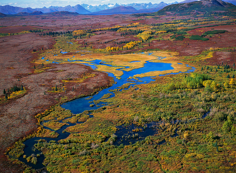
Tuesday, July 12, 2016

NO PEBBLE MINE #200, Pictures from Ground Zero: NO PEBBLE MINE #200, Pictures from Ground Zero: The rocky beach that faces Tikchik Narrows is just below the main lodge and dining hall of Tikchik Narrows Lodge. Here the current picks up as water flows out of Nuyakuk lake into Tikchik lake across a relatively shallow bottom, and in the quiet of dawn and evening, you can see the riffles of fish swimming upstream as they pass by. As tired as guests might be from their daily adventures, those riffles always draw a few eager anglers down to this water's edge during the twilight hours of the day. On this particular morning, weather gave us a broken sky and some low clouds that clung to the hillsides of the opposite shore. Although the sun was not up, it had colored the sky and the reflection turned the glassy water of the Narrows softly pink. Several guests joined me and began to cast into the blue. This morning, fish would NOT BE the prize.
photograph(s) © copyright, ROBERT GLENN KETCHUM, 2016, @RbtGlennKetchum @LittleBearProd @NRDC @OrvisFlyFishing #NoPebbleMine #LittleBearProd
Follow Robert Glenn Ketchum's Photographic Activism Online:
SOCIAL MEDIA by @LittleBearProd: http://www.LittleBearProd.com
Tuesday, July 5, 2016

NO PEBBLE MINE #199, Pictures from Ground Zero:
NO PEBBLE MINE #199, Pictures from Ground Zero: I am not exactly sure what happened on the far horizon, but the sun rose, lighted the clouds as you saw in the last post, then it seemed to fade for a moment, only to LITERALLY explode like this. Perhaps it was a passing cloud that blocked the sunrise for a moment, but it has certainly gone away. Most of us have heard the phrase "fire in the sky," - just sayin'! Now, to be fair, it does NOT do this every morning and evening. Tikchik experiences a LOT of rain and weather, as well as early morning and late evening fogs, but when it does go off it is a great way to start the day. For the next few posts we will walk over to the Narrows and watch the magic of a sunrise there. Please join me and you can fish too!
photograph(s) © copyright, ROBERT GLENN KETCHUM, 2016, @RbtGlennKetchum @LittleBearProd @NRDC @OrvisFlyFishing #NoPebbleMine #LittleBearProd
Follow Robert Glenn Ketchum's Photographic Activism Online:
SOCIAL MEDIA by @LittleBearProd: http://www.LittleBearProd.com
_____________________________________________________
Wednesday, June 29, 2016

NO PEBBLE MINE #198, Pictures from Ground Zero:
NO PEBBLE MINE #198, Pictures from Ground Zero: The southern tip of the peninsula upon which Tikchik Narrows Lodge is built, looks south across a wide expanse of water and to low foothills in the distance. There are few obstacles in the way of the view, and the sky is fed by a continuous cloud stream coming from Bristol Bay and the Bering Sea. Early in the morning, sun rise comes from the left, and in the evening, the sunset comes from the right. This is a pretty sweet spot for what is often an unparalleled sky-show. TI am on a quiet dawn patrol, a very nice way to begin a day. If you ever needed a wake-up call, here comes one and there is no alarm clock and no caffeine. Stay tuned next week to see what a difference a few minutes make.
photograph(s) © copyright, ROBERT GLENN KETCHUM, 2016, @RbtGlennKetchum @LittleBearProd @NRDC @OrvisFlyFishing #NoPebbleMine #LittleBearProd
Follow Robert Glenn Ketchum's Photographic Activism Online:
SOCIAL MEDIA by @LittleBearProd: http://www.LittleBearProd.com
_____________________________________________________
Wednesday, June 22, 2016

NO PEBBLE MINE #197, Pictures from Ground Zero:
NO PEBBLE MINE #197, Pictures from Ground Zero: While some of the tundra landscape can be traversed if it is high and dry enough, most of it is a thrash that gives you the ILLUSION you can walk through it unimpeded, but you can't. Here is a classic reality check. From the boat as we approached this shore, it looked like willows and grasses that we might be able to push through. Once actually in the terrain, it becomes much more complex with boulders and fallen logs "hiding" beneath the tundra mat. Since most of the time it is raining, everything is wet and slippery, and it is easy to turn an ankle or stumble and smash your knee into something hard you can't even see. You CAN hike in this environment, BUT it is VERY slow going. As my 1st nation friends pointed out, "come back in winter, everything is frozen and you can walk anywhere you like." We WILL do that!
photograph(s) © copyright, ROBERT GLENN KETCHUM, 2016, @RbtGlennKetchum @LittleBearProd @NRDC @OrvisFlyFishing #NoPebbleMine #LittleBearProd
Follow Robert Glenn Ketchum's Photographic Activism Online:
SOCIAL MEDIA by @LittleBearProd: http://www.LittleBearProd.com
_____________________________________________________

NO PEBBLE MINE #196, Pictures from Ground Zero:
NO PEBBLE MINE #196, Pictures from Ground Zero: I have mentioned before that the terrain in Tikchik can be very difficult to travel through AND there are animals out here that will eat you. When you are on the peninsula that that forms the grounds of Tikchik Narrows Lodge getting around is relatively easy, but once you cross the narrow strip of land connecting to Bud's house, everything changes. There are no established paths or boardwalks, just A LOT of tundra thrashing. During one of my visits to the lodge, the lodge was hosting two "local" hunters seeking a "trophy" moose. They used a lodge boat to reach the hunt location, and then walked inland through terrain pretty much like this. They got their moose, but it took TWO DAYS of working all day, and many boat trips to get it all out - they were exhausted (and Alaska Airlines made them buy a seat for the trophy rack if they wanted to fly it back to Anchorage - LOL).
photograph(s) © copyright, ROBERT GLENN KETCHUM, 2016, @RbtGlennKetchum @LittleBearProd @NRDC @OrvisFlyFishing #NoPebbleMine #LittleBearProd
Follow Robert Glenn Ketchum's Photographic Activism Online:
SOCIAL MEDIA by @LittleBearProd: http://www.LittleBearProd.com
_____________________________________________________
Wednesday, June 8, 2016 
NO PEBBLE MINE #195, Pictures from Ground Zero:
NO PEBBLE MINE #195, Pictures from Ground Zero: The on-the-ground POV at Tikchik Narrows Lodge is dramatic in all directions. This is looking south from Tikchik Narrows across the lake that is created by the outflow from Nuyakuk. In the distance you can see some mountains that have VERY DISTINCT features as you get closer. We will pass by them in many seasons and changing weather as I fly daily routes delivering guests to fishing locations. To the left is a narrow strip of land connecting Bud's house to the lodge complex and it also serves as the summer landing strip for wheeled airplanes that might deliver fresh food. The lodge sits behind me and to the left side of this rocky peninsula we are on, is the float plane dock and boat launch area. To the right lies a gravel beach that faces Tikchik Narrows directly and even though most guests are worn out from their day, inevitably in the early morning before breakfast, and in the evening after dinner some of them wade in right there - partly for the fishing, but also for the "show" as you will see.
photograph(s) © copyright, ROBERT GLENN KETCHUM, 2016, @RbtGlennKetchum @LittleBearProd @NRDC @OrvisFlyFishing #NoPebbleMine #LittleBearProd
Follow Robert Glenn Ketchum's Photographic Activism Online:
SOCIAL MEDIA by @LittleBearProd: http://www.LittleBearProd.com
_____________________________________________________

NO PEBBLE MINE #194, Pictures from Ground Zero:
NO PEBBLE MINE #194, Pictures from Ground Zero: When you are staying there, Tikchik Narrows Lodge seems like a large place, but as this view shows, it looks small in the big world of the park. Let me define what you see in this image: frozen over Nuyakuk Lake is the white expanse that fills the left side of the frame, as the water coming out of the lake flows into the shallow Tikchik Narrows it is turbulent enough to remain open. In summer you would see that the lodge sits on a peninsula of land nearly surrounded by water. The houses at the tip of the peninsula are the main lodge, dining room, kitchen, and staff operations and at any given time there may be as many as 30-40 people gathered there to dine, serve, and plan the next day. The smaller random cabins are gear sheds for the boats, planes, and fishing equipment, and the cluster of cabins to the right are the guest rooms. If you look carefully you will see two airplanes tethered in the foreground and follow the snowmobile tracks in the background into that small clump of trees and you will see the A-frame living room window of @BudHodson's very sizable house.
photograph(s) © copyright, ROBERT GLENN KETCHUM, 2016, @RbtGlennKetchum @LittleBearProd @NRDC @OrvisFlyFishing #NoPebbleMine #LittleBearProd
Follow Robert Glenn Ketchum's Photographic Activism Online:
SOCIAL MEDIA by @LittleBearProd: http://www.LittleBearProd.com
_____________________________________________________
Wednesday, May 25, 2016

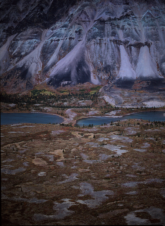
NO PEBBLE MINE #193, Pictures from Ground Zero:
NO PEBBLE MINE #193, Pictures from Ground Zero: A map view at this point will help putWood-Tikchik State Park in perspective. This map provided to the public by the State of Alaska Department of Natural Resources clearly shows how the big, fjord-like lakes have been formed at the foot of the Wood Mountains. Those lakes to the south are closest to the town of Dillingham and are actually reached by a road that comes right to the edge of the park. As you move north through the lake chain, however, you move into ever wilder sections of the park. Near the center of this map you can see Nuyakuk Lake, which has been measured to 900ft in depth, and many believe is home to a Loch Ness-type creature. Just where that lake narrows and extends to the east (left), you will also see the designated site of Tikchik Narrows Lodge. This will be our base camp for a while as we tour the park's diverse terrain, thanks to the generosity of Bud Hodson and his staff and clients.
photograph(s) © copyright, ROBERT GLENN KETCHUM, 2016, @RbtGlennKetchum @LittleBearProd @NRDC @OrvisFlyFishing #NoPebbleMine #LittleBearProd
Follow Robert Glenn Ketchum's Photographic Activism Online:
SOCIAL MEDIA by @LittleBearProd: http://www.LittleBearProd.com
_____________________________________________________
Wednesday, May 18, 2016

NO PEBBLE MINE #192, Pictures from Ground Zero:
NO PEBBLE MINE #192, Pictures from Ground Zero: We are in the middle of one of the greatest recreational fisheries in the world, and this is the heart of it. The Tikchik Lake system, a chain of large, glacially carved lakes at the foot of the mountains in Wood-Tikchik State Park constitute a significant part of the Bristol Bay watershed and enjoy the benefits of both the native fish and those that are spawning in the numerous rivers. Here you are looking at Grant River falls. If you were staying at the nearby Tikchik Narrows Lodge on any given morning you, a guide, and 3 other guests would be flown in to the small lake in the background. After a marshy meadow walk, some forest paths, and a slippery decent along the side of the waterfall, you would spend the rest of the day in your waders, fishing your way downstream to the next lake, where you would be picked up in the late afternoon and flown back to the lodge,..exhausted!
photograph(s) © copyright, ROBERT GLENN KETCHUM, 2016, @RbtGlennKetchum @LittleBearProd @NRDC @OrvisFlyFishing #NoPebbleMine #LittleBearProd
Follow Robert Glenn Ketchum's Photographic Activism Online:
SOCIAL MEDIA by @LittleBearProd: http://www.LittleBearProd.com
_____________________________________________________
Wednesday, May 11, 2016

NO PEBBLE MINE #191, Pictures from Ground Zero:
NO PEBBLE MINE #191, Pictures from Ground Zero: We are now being officially greeted into the lake section of #WoodTikchikStatePark by #TikchikMountain on the right and #TickchikLake to the left. Tickchik Lake connects to the the VERY large and deep #NuyakukLake through the #TickchikNarrows. We are well into the heart of the park at this point, as the closest road connection only comes to #AleknagikLake, one of the southern-most in the park and many rugged, wilderness miles away from our location. However, you may recall I previously posted that there is only ONE LODGE actually in the park, and it sits on the rocky point that creates Tikchik Narrows. #TikchikNarrowsLodge (www.tikchiklodge.com) has been owned and operated by @BudHodson since 1986. Bud is a GREAT host, quite a fisherman himself, and Tikchik is a fantastic lodge. Bud also wanted to support my creation of the book, "Wood-Tikchik: Alaska's Largest State Park" as part of the NO PEBBLE MINE campaign, and so he invited me to stay at the lodge and fly with his clients when they went out each day so that I could see all of the park. I am most grateful to Bud for being so generous and supportive and if you enjoy the images in this part of the blog, you can thank him for helping me.
photograph(s) © copyright, ROBERT GLENN KETCHUM, 2016, @RbtGlennKetchum @LittleBearProd @NRDC @OrvisFlyFishing #NoPebbleMine #LittleBearProd
Follow Robert Glenn Ketchum's Photographic Activism Online:
SOCIAL MEDIA by @LittleBearProd: http://www.LittleBearProd.com
_____________________________________________________
NO PEBBLE MINE #190, Pictures from Ground Zero:
NO PEBBLE MINE #190, Pictures from Ground Zero: In a view similar to the last post, we are approaching the section of large lakes in #WoodTikchikStatePark that were created by glaciers from the #WoodMountains. As we fly above the rising foothills, this POV reveals a number of streams that have coalesced into a small wetland and the "hills" are quickly becoming mountains. This landscape abounds in water, fish, and the other animals and birds that feed on them. They are EVERYWHERE in this stunning 1.6million-acre park. Conversely there are VERY FEW humans. Occasionally kayakers and canoeists camp, but there are no established camp sites and you are definitely in the food chain. There is only ONE LODGE within the park that sleeps about 30 and it is pricey, BUT it is a location like few others in the world, and on most days you and the other guests are the only people around for many, many miles.
photograph(s) © copyright, ROBERT GLENN KETCHUM, 2016, @RbtGlennKetchum @LittleBearProd @NRDC @OrvisFlyFishing #NoPebbleMine #LittleBearProd
Follow Robert Glenn Ketchum's Photographic Activism Online:
SOCIAL MEDIA by @LittleBearProd: http://www.LittleBearProd.com
_____________________________________________________
Wednesday, April 27, 2016

NO PEBBLE MINE #189, Pictures from Ground Zero:
NO PEBBLE MINE #189, Pictures from Ground Zero: At last the rising terrain becomes pronounced and the #WoodMountains and #TikchikLakes come into view. The summits in the distance rise to 8,000-feet, and we will ultimately investigate that backcountry. But for now, notice in the landscape beneath the wing the number of small river valleys that have formed, flowing down out of the foothills. I count at least six different stream systems, and a small wetland/pond (lower, middle) in the scope of this view. Wilderness, fish, and numerous larger animals are EVERYWHERE out there. This is no place for the intrusions of industrial development. Southwest Alaska is a paradise of wilderness, clean air, clean water, and a billion-dollar-a-year fishery. Say NO TO THE PEBBLE MINE!
photograph(s) © copyright, ROBERT GLENN KETCHUM, 2016, @RbtGlennKetchum @LittleBearProd @NRDC @OrvisFlyFishing #NoPebbleMine #LittleBearProd
Follow Robert Glenn Ketchum's Photographic Activism Online:
SOCIAL MEDIA by @LittleBearProd: http://www.LittleBearProd.com
_____________________________________________________
Wednesday, April 20, 2016

NO PEBBLE MINE #188, Pictures from Ground Zero:
NO PEBBLE MINE #188, Pictures from Ground Zero: There are many large lakes in #WoodTikchikStatePark, and here at the "lower" end of the park are two, connected by a small pristine little section of a river. If you study this landscape, you will notice parts of it are visibly uphill from the shoreline as hills and swales begin to convolute the terrain. The tundra in the foreground is relatively dry and hard, not so saturated as you saw in some of the previous posts. At the heart of this park at the foot of the #WoodMountains lie a chain of REALLY large lakes, connected by large and productive fishing rivers. It is a system precisely like this one, only on a much larger scale and that is exactly where we are headed. Those lakes were glacially carved by ice descending from the Wood Mountains, and they are not only huge, but many of them are VERY deep. In the nearby villages that hunt and fish this land, there are those that believe one of these lakes has a creature described as quite like the #LochnessMonster.
photograph(s) © copyright, ROBERT GLENN KETCHUM, 2016, @RbtGlennKetchum @LittleBearProd @NRDC @OrvisFlyFishing #NoPebbleMine #LittleBearProd
Follow Robert Glenn Ketchum's Photographic Activism Online:
SOCIAL MEDIA by @LittleBearProd: http://www.LittleBearProd.com
_____________________________________________________

NO PEBBLE MINE #187, Pictures from Ground Zero:
NO PEBBLE MINE #187, Pictures from Ground Zero: Moving ever closer to the heart of #WoodTikchikStatePark, big lakes now begin to appear. Once again, water's presence in/on the landscape is clearly defined by what vegetation is growing where. When you are out walking around in this terrain, following the colors and paying attention where they flow can make the difference in whether you find this landscape impassable or not - hint: stay near the trees and keep your boots or waders on! There ARE a lot of game trails that can be followed, but the primary users in this park are bear -REALLY big grizzlies - so unfortunately "walking about" is a calculated risk.
photograph(s) © copyright, ROBERT GLENN KETCHUM, 2016, @RbtGlennKetchum @LittleBearProd @NRDC @OrvisFlyFishing #NoPebbleMine #LittleBearProd
Follow Robert Glenn Ketchum's Photographic Activism Online:
SOCIAL MEDIA by @LittleBearProd: http://www.LittleBearProd.com
_____________________________________________________
Wednesday, April 6, 2016

NO PEBBLE MINE #186, Pictures from Ground Zero:
NO PEBBLE MINE #186, Pictures from Ground Zero: I warned you these pictures would become increasingly unbelievable! THIS was MY #WilliamHenryJackson moment. As the photographer on the #Yellowstone survey expedition, Jackson was the first to photograph the Yellowstone geysers and amazing, multi-colored thermal pools. While similar in some coloration to the famous "Morning Glory Pool," what we are looking at here in the rising foothills of #WoodTikchikStatePark, is a freshwater spring glowing radiantly amidst fall tundra. A river runs past in the background, and off to the left is water of another color as it comes from a lake. If you look carefully, you can see numerous animal trails along that lakeshore. Given the specific "points" to which these trails lead, I would suggest bear are looking for salmon.
photograph(s) © copyright, ROBERT GLENN KETCHUM, 2016, @RbtGlennKetchum @LittleBearProd @NRDC @OrvisFlyFishing #NoPebbleMine #LittleBearProd
Follow Robert Glenn Ketchum's Photographic Activism Online:
SOCIAL MEDIA by @LittleBearProd: http://www.LittleBearProd.com
_____________________________________________________
Wednesday, March 30, 2016

NO PEBBLE MINE #185, Pictures from Ground Zero:
NO PEBBLE MINE #185, Pictures from Ground Zero: Closer to the "lake section" of #WoodTikchikStatePark, ever-larger tree islands and hilly terrain emerge. Water is everywhere and so are salmon, trout, Arctic char, bear, wolves, caribou, eagles, and all the other things that are connected to each other in this stunning, productive ecosystem. Some of these images become progressively more unbelievable as well, so let me just state this: these are 645 (120mm/medium format) transparency film images. The ones showing the astounding color resonance are the result of two peak falls, neither of which lasted more than 10-days. It rained almost everyday, and flying as weather broke off and the skies opened, optimized the use of (water)saturated colors in the landscape below me. (Check out an #EliotPorter book of forest images to see how many of those pictures have been taken in the rain and overcast - discovering them was certainly part of my learning curve.) Now watch what happens below my wings in Wood-Tikchik!
photograph(s) © copyright, ROBERT GLENN KETCHUM, 2016, @RbtGlennKetchum @LittleBearProd @NRDC @OrvisFlyFishing #NoPebbleMine #LittleBearProd
Follow Robert Glenn Ketchum's Photographic Activism Online:
SOCIAL MEDIA by @LittleBearProd: http://www.LittleBearProd.com
_____________________________________________________
Wednesday, March 23, 2016

NO PEBBLE MINE #184, Pictures from Ground Zero:
NO PEBBLE MINE #184, Pictures from Ground Zero: Tree "islands" have formed where the ground rises enough to drain, as even just a slight elevation helps keep the roots from rotting. All that moisture in the surrounding tundra creates an almost daily diurnal fog that forms at sunrise, and again at sunset. It can be QUITE dense, but it is usually brief, and dissipates as the day warms up, or the night cools down. As we draw closer to the mountains, these broad saturated expanses give way to more forests, lakes, and streams. Regardless, ALL of these waters coalesce, and flow from the park into #BristolBay, and salmon from the bay follow those streams and rivers back into the park to spawn.
photograph(s) © copyright, ROBERT GLENN KETCHUM, 2016, @RbtGlennKetchum @LittleBearProd @NRDC @OrvisFlyFishing #NoPebbleMine #LittleBearProd
Follow Robert Glenn Ketchum's Photographic Activism Online:
SOCIAL MEDIA by @LittleBearProd: http://www.LittleBearProd.com
_____________________________________________________
Wednesday, March 16, 2016

NO PEBBLE MINE #183, Pictures from Ground Zero:
NO PEBBLE MINE #183, Pictures from Ground Zero: As we enter the domain of #WoodTikchikStatePark, the landscape begins to change in VERY striking ways. For what it's worth, of all the places I've photographed in my life, none has been as varied and beautiful as this 1-1/2 million acre niche of mountains, lakes, and river systems. In the last post I mentioned how the rising slope of the landscape changes the drainage patterns. Here you can see those patterns distinctly. Water saturation dictates vegetation growth, and each group of plants has differing shades of fall color. Tree "islands" have emerged in the driest places, and various tundra plants that follow the downstream flow of water cause the landscape to appear as though it were painted by strokes of a brush.
photograph(s) © copyright, ROBERT GLENN KETCHUM, 2016, @RbtGlennKetchum @LittleBearProd @NRDC @OrvisFlyFishing #NoPebbleMine #LittleBearProd
Follow Robert Glenn Ketchum's Photographic Activism Online:
SOCIAL MEDIA by @LittleBearProd: http://www.LittleBearProd.com
_____________________________________________________
Wednesday, March 9, 2016

NO PEBBLE MINE #182, Pictures from Ground Zero:
NO PEBBLE MINE #182, Pictures from Ground Zero: As we draw closer to #WoodTikchikStatePark, the landscape rises gradually, building in to the ranges of the Wood Mountains. Just to the west and north is the heart of the #BeringSea, so some kind of dynamic weather moves across this landscape virtually EVERY day. In the winter, ranges in the park and elsewhere might accumulate as much as 20-feet of snow. And in the other seasons, it might rain every day, even if just a little. This POV is from near the town of #Dillingham, looking into the beginning of the lake section of the park. As we approach the more mountainous territory, there is a notable rise in the landscape that alters drainage patterns. And the saturated tundra plains we have left behind us morph into a terrain of lakes connected by numerous river systems surrounded by foothills, domes, and in many places, stands of dense forest.
photograph(s) © copyright, ROBERT GLENN KETCHUM, 2016, @RbtGlennKetchum @LittleBearProd @NRDC @OrvisFlyFishing #NoPebbleMine #LittleBearProd
Follow Robert Glenn Ketchum's Photographic Activism Online:
SOCIAL MEDIA by @LittleBearProd: http://www.LittleBearProd.com
_____________________________________________________
Wednesday, March 2, 2016

NO PEBBLE MINE #181, Pictures from Ground Zero:
NO PEBBLE MINE #181, Pictures from Ground Zero: For me, this image speaks to many issues regarding an open-pit mine in this environment. At first glance, you may THINK there is solid ground here somewhere, yet there is next-to-none. This is a saturated tundra plain, and there is virtually no solid ground, except perhaps quite close to the trees where you can see the game trails. The rest is a tiring boot slog. In building an open-pit mine, FROM THE VERY FIRST HOLE TO BE DUG, water will flow into the hole and have to be pumped out... A LOT of water! A mine 2,000-feet deep in this environment is a (bad) joke! NO PEBBLE MINE! NO COAL BURNING! NO ACIDIC IRON ORE SLURRY! NO CYANIDE SLURRY TAILINGS LAGOONS SPRAWLING ACROSS 20-SQUARE-MILES poisoning all the animals and birds!!
photograph(s) © copyright, ROBERT GLENN KETCHUM, 2016, @RbtGlennKetchum @LittleBearProd @NRDC @OrvisFlyFishing #NoPebbleMine #LittleBearProd
Follow Robert Glenn Ketchum's Photographic Activism Online:
SOCIAL MEDIA by @LittleBearProd: http://www.LittleBearProd.com
_____________________________________________________
Wednesday, February 24, 2016

NO PEBBLE MINE #180, Pictures from Ground Zero:
NO PEBBLE MINE #180, Pictures from Ground Zero: The rivers become streams, and the streams become creeks. The forest diminishes in many places, and the saturated tundra sprawls across the terrain. Puddles, pools, ponds, lakes - water everywhere - flowing, trickling, falling out of the sky, and blowing in off the ocean. Having gills, or a really big furry coat, out here seems like a good idea. The landscape of Southwest can be defined as one of the least-developed, most well-evolved, water purifying ecosystems on the planet. The benefits of it are some of the most biological diverse freshwater rivers in North America, and the most productive salmon fishery in the world. Why would ANYONE want to introduce any kind of toxicity into this? WAKE UP America! This fishery is the last clean one that you have not yet killed off, or stripped. We have one more chance to do it right. Tell the @EPA to protect our parks, refuges, fishery, air, and water quality from international mineral speculators, and their poisonous byproducts. EPA administrator #McCarthy (@GinaEPA), please say NO TO THE PEBBLE MINE.
photograph(s) © copyright, ROBERT GLENN KETCHUM, 2016, @RbtGlennKetchum @LittleBearProd @NRDC @OrvisFlyFishing #NoPebbleMine #LittleBearProd
Follow Robert Glenn Ketchum's Photographic Activism Online:
SOCIAL MEDIA by @LittleBearProd: http://www.LittleBearProd.com
_____________________________________________________
Wednesday, February 17, 2016

NO PEBBLE MINE #179, Pictures from Ground Zero:
NO PEBBLE MINE #179, Pictures from Ground Zero: Still relatively close to the #Nushagak, there are many large tributaries and dense patches of forest. As the flight carries us farther west and north, however, the tributaries diminish in size, and the tundra and wetlands begin to assert themselves over the trees. THIS is the true heart of the fishery. And this landscape is a myriad of lakes, rivers, and streams wending their way around gently, rolling hills. Much of this part of Southwest is NOT protected by park or refuge status, and various First Nation villages claim rights to it, and act as stewards of it as it is part of their subsistence lifestyles.
photograph(s) © copyright, ROBERT GLENN KETCHUM, 2016, @RbtGlennKetchum @LittleBearProd @NRDC @OrvisFlyFishing #NoPebbleMine #LittleBearProd
Follow Robert Glenn Ketchum's Photographic Activism Online:
SOCIAL MEDIA by @LittleBearProd: http://www.LittleBearProd.com
_____________________________________________________
Wednesday, February 10, 2016

NO PEBBLE MINE #178, Pictures from Ground Zero:
NO PEBBLE MINE #178, Pictures from Ground Zero: Our flight path crossed the #NushagakRiver leaving #LakeClarkNationalPark, #KatmaiNationalPark, and #LakeIliamna (ALL places this blog has previously explored) behind us. Off our left wing, you can look out over #BristolBay. With the mouth of the "Nush" below us, and the #KvichakRiver mouth in the distance, THIS IS THE CLEANEST, MOST PRODUCTIVE #SALMON FISHERY IN THE WORLD!!! In addition to salmon, there is herring, several species of crab, halibut, etc., NOT TO MENTION it's all being fed by one of the most diverse freshwater systems in the world!!! #SouthwestAlaska and its stunning array of parks, refuges, wildlands, and lakes IS the ecosystem that makes the billion dollar fishery possible. Thank you President Obama (@BarackObama) for removing Bristol Bay from further oil and gas lease consideration. Now, please encourage @EPA administrator #McCarthy (@GinaEPA) to say NO TO THE PEBBLE MINE!
photograph(s) © copyright, ROBERT GLENN KETCHUM, 2016, @RbtGlennKetchum @LittleBearProd @NRDC @OrvisFlyFishing #NoPebbleMine #LittleBearProd
Follow Robert Glenn Ketchum's Photographic Activism Online:
SOCIAL MEDIA by @LittleBearProd: http://www.LittleBearProd.com
_____________________________________________________
Wednesday, February 3, 2016

NO PEBBLE MINE #177, Pictures from Ground Zero:
NO PEBBLE MINE #177, Pictures from Ground Zero: From this POV we are practically above the proposed Pebble mine site. On the other side of the large hill is the headwater of #TalarikCreek, and beyond that you can see the broad shoreline of #LakeIliamna. Below us the meanders of the #Koktuli and the #Stuyahok rivers wend their way downstream from the site to their juncture with the #Mulchatna, and ultimately the #Nushagak. We are looking at some of the most productive salmon headwaters in the world. This is NO place for a cyanide-leach gold mine and tailings lagoon. PLEASE!!!! SAY NO TO THE PEBBLE MINE!
photograph(s) © copyright, ROBERT GLENN KETCHUM, 2016, @RbtGlennKetchum @LittleBearProd @NRDC @OrvisFlyFishing #NoPebbleMine #LittleBearProd
Follow Robert Glenn Ketchum's Photographic Activism Online:
SOCIAL MEDIA by @LittleBearProd: http://www.LittleBearProd.com
_____________________________________________________
Wednesday, January 27, 2016

NO PEBBLE MINE #176, Pictures from Ground Zero:
NO PEBBLE MINE #176, Pictures from Ground Zero: To remind you, we have now "joined" the imaginary flight in this post that left #TwinLakesBasin in #LakeClarkNationalParkandPreserve, headed toward #Dillingham and #WoodTikchikStatePark. After following some valleys through low clouds we've emerged from the mountains and are flying above numerous rivers that feed into Lake Clark, visible now out the left side of the plane. Below the wings, the #Kijik, the #Koksetna, and the #Chulitna meander across the landscape like some fantastic writhing snakes. We're approaching the backside of the proposed Pebble mine site, and the haul road would have to thread its way over and around some of these rivers. Just SAY NO (to the Pebble mine.)
photograph(s) © copyright, ROBERT GLENN KETCHUM, 2016, @RbtGlennKetchum @LittleBearProd @NRDC @OrvisFlyFishing #NoPebbleMine #LittleBearProd
Follow Robert Glenn Ketchum's Photographic Activism Online:
SOCIAL MEDIA by @LittleBearProd: http://www.LittleBearProd.com
_____________________________________________________
Wednesday, January 20, 2016

NO PEBBLE MINE #175, Pictures from Ground Zero:
NO PEBBLE MINE #175, Pictures from Ground Zero: It was cold and drizzling when we awoke, yet the weather remained “high”; meaning our plane would probably be flying. We ate, packed gear, said goodbye to “wolf” beach, and floated on to our pick-up. As we would soon be sky bound, imagine that we are now going to “merge” with the fictitious tour “flight” we left coming out of #LakeClarkNationalPark (post #160). We will "join" that part of our exploration and head across southwest Alaska, bound for #WoodTikchikStatePark....
photograph(s) © copyright, ROBERT GLENN KETCHUM, 2016, @RbtGlennKetchum @LittleBearProd @NRDC @OrvisFlyFishing #NoPebbleMine #LittleBearProd
Follow Robert Glenn Ketchum's Photographic Activism Online:
SOCIAL MEDIA by @LittleBearProd: http://www.LittleBearProd.com
_____________________________________________________
Wednesday, January 13, 2016

NO PEBBLE MINE #174, Pictures from Ground Zero:
NO PEBBLE MINE #174, Pictures from Ground Zero: I suggested we hold our ground and remain motionless and quiet. We could see the spot where the wolves appeared, and our position seemed well hidden to that vantage point. Perhaps three or four minutes went by AND THEN a huge, white wolf appeared at the top of that same small rise. Not chasing blindly, it stood studying the landscape of the meadow, very carefully scanning every rock and bush and occasionally scenting the air. With us all staring breathlessly, the searching gaze suddenly fixed directly on us. All of us were aware that the wolf knew we were there, and without a second of hesitation, it bolted off in the opposite direction, AWAY from us. THAT was the Alpha male! We were wired all the way back to camp and through dinner, the encounter was quite an adrenalin rush. I will probably never be that close to wolves in the wild again. Weather came in with nightfall, and as we ate, clouds obscured the moon. Tomorrow we would move on to the plane pick-up point.
photograph(s) © copyright, ROBERT GLENN KETCHUM, 2016, @RbtGlennKetchum @LittleBearProd @NRDC @OrvisFlyFishing #NoPebbleMine #LittleBearProd
Follow Robert Glenn Ketchum's Photographic Activism Online:
SOCIAL MEDIA by @LittleBearProd: http://www.LittleBearProd.com
_____________________________________________________
Wednesday, January 6, 2016

NO PEBBLE MINE #173, Pictures from Ground Zero:
NO PEBBLE MINE #173, Pictures from Ground Zero: After descending through a dry gully, we once again found ourselves sloshing through a tundra-meadow-swamp. We were about the middle of our traverse, and within sight of the dry edge we were trying to reach when we first heard the thump and splash of something large running. Then, a female caribou blew by right in front of us bounding along that drier, firmer edge. She passed quickly without noticing us, and was remarkably close. We were in a kind of hushed moment after she passed when I realized, SHE WAS IN FLIGHT FROM SOMETHING! Immediately I suggested we hide as best we could to see if something was in pursuit, and all agreed. Within minutes, two wolves with their noses to the ground loped through following her trail scent. They also failed to notice us until almost completely past our hide, then they appeared startled. One actually broke off the chase and fled. Wolves are hunted here. These were young and careless or they would never have gotten so close. Where is the rest of the pack and the Alpha male leader?
photograph(s) © copyright, ROBERT GLENN KETCHUM, 2016, @RbtGlennKetchum @LittleBearProd @NRDC @OrvisFlyFishing #NoPebbleMine #LittleBearProd
Follow Robert Glenn Ketchum's Photographic Activism Online:
SOCIAL MEDIA by @LittleBearProd: http://www.LittleBearProd.com
_____________________________________________________
Wednesday, December 30, 2015

NO PEBBLE MINE #172, Pictures from Ground Zero:
NO PEBBLE MINE #172, Pictures from Ground Zero: The ridgeline was solid rock with little vegetation. and it was very easy to ramble around. We followed it up and to its other end where we were offered this POV. The small flash of blue mid-frame right is the #Chilikadrotna River (a.k.a. The Chili), several miles upstream from our camp. Following that valley from right-to-left the Chili winds back, ultimately bending sharply right, around the prominent mountain in the middle of the frame. Behind that summit lies #TwinLakes basin where we began our float. The much higher peaks surrounding that basin aren't visible from this position. I thought it was time for a nice nap! As the day passed, clouds moved in and the breeze picked up, so we decided it was time to leave the exposure of the ridge and head back to camp.
photograph(s) © copyright, ROBERT GLENN KETCHUM, 2015, @RbtGlennKetchum @LittleBearProd @NRDC @OrvisFlyFishing #NoPebbleMine #LittleBearProd
Follow Robert Glenn Ketchum's Photographic Activism Online:
SOCIAL MEDIA by #LittleBearProd: http://www.LittleBearProd.com
_____________________________________________________
Wednesday, December 23, 2015

NO PEBBLE MINE #171, Pictures from Ground Zero:
NO PEBBLE MINE #171, Pictures from Ground Zero: We calculated correctly and our shrubby ravine led us onto a rocky summit at higher elevation. We found ourselves on a large stone ridgeline that ran for several hundred yards and offered panoramic views in all directions. It also had a number of great places to shelter in the warm sun, out of the breeze, so we could enjoy our lunch and take in our wild surroundings. This first POV is downriver, and running left-to-right near the top of the frame, you can see the pale ribbon of water that forms the #Chilikadrotna. You can also see the mixed terrain we picked our way up through to reach this vantage point. What a world southwest Alaska is. May it stay wild forever, AND we can start by saying NO TO THE PEBBLE MINE!
photograph(s) © copyright, ROBERT GLENN KETCHUM, 2015, @RbtGlennKetchum @LittleBearProd @NRDC @OrvisFlyFishing #NoPebbleMine #LittleBearProd
Follow Robert Glenn Ketchum's Photographic Activism Online:
SOCIAL MEDIA by #LittleBearProd: http://www.LittleBearProd.com
_____________________________________________________
Wednesday, December 16, 2015

NO PEBBLE MINE #170, Pictures from Ground Zero:
NO PEBBLE MINE #170, Pictures from Ground Zero: After a lengthy slog through the "meadow," the terrain finally began to climb again and the pooling, water saturated ground gave way to a considerable bush, but it was dry and navigable, AND it led up! We followed of gully of tundra and berries that was the first non-spongy ground we had walked on since we left camp on the sandbar. The pace of the hike quickened and we also began to gain some serious view elevation. Rock faces appeared here and there so we were hopeful we had found a route to the summit. In this picture the #Chilikadrotna river is in the distance to the far left. Ever been in a place of this scale and no one else except you and your friends are within miles?
photograph(s) © copyright, ROBERT GLENN KETCHUM, 2015, @RbtGlennKetchum @LittleBearProd @NRDC @OrvisFlyFishing #NoPebbleMine #LittleBearProd
Follow Robert Glenn Ketchum's Photographic Activism Online:
SOCIAL MEDIA by #LittleBearProd: http://www.LittleBearProd.com
_____________________________________________________
Wednesday, December 9, 2015

NO PEBBLE MINE #169, Pictures from Ground Zero:
NO PEBBLE MINE #169, Pictures from Ground Zero: We spent a good bit of time picking our way through the soggy tundra bench and then we came to another rise. After scrambling up we found ourselves at the literal edge of the tree line. Stunted as they were, the trees final stopped altogether because the ground was so saturated that their roots actually rotted. “Saturated” would actually be an understatement. This "meadow" before us was more like a high elevation swamp trapped in a large pocket of rock. We had on our high boots and raingear, so we were unlikely to get wet, however this surely slowed down the days hike. Between the blackwater pools, the berry bushes and grasses were growing on tussocks which were large, very spongy, unstable mounds of vegetation. To navigate, you had to step from one to another, because the pools were quite deep, so there was no walking “through” them. (Among some of us, the belief was held that these pools were bottomless, and once sucked in you would never get out... LOL!)
photograph(s) © copyright, ROBERT GLENN KETCHUM, 2015, @RbtGlennKetchum @LittleBearProd @NRDC @OrvisFlyFishing #NoPebbleMine #LittleBearProd
Follow Robert Glenn Ketchum's Photographic Activism Online:
SOCIAL MEDIA by #LittleBearProd: http://www.LittleBearProd.com
_____________________________________________________
Wednesday, December 2, 2015

NO PEBBLE MINE #168, Pictures from Ground Zero:
NO PEBBLE MINE #168, Pictures from Ground Zero: By now, I should know better than to ever get down on my knees and look too closely as that could be the end of the day (LOL). Having said that, however, you would also be stupid not to! And, of all the weird-beautiful niches I have been wandering around in, this up-close, is one of the weirdest. This relatively flat “bench” we were crossing, was adorned by stunted trees and this luxurious tundra because it was wet, much lower, warmer, and more snow-free than the higher lake section from which we had floated. Given the very spongy conditions and amazing array of diversity, I felt a bit guilty imprinting this carpet with our boots, but I soon realized, within minutes of our passing, the foot-shape left by our collective step, simply disappeared as the mosses we had compressed rapidly re-expanded and our pathway disappeared behind us. Time to take a GPS reading as we won't be following our own path back to camp! You do not want to be out all day to find yourself tired, cold, hungry and slightly "off" target when you descend and realize the food and tents are well up or down river from your position.
photograph(s) © copyright, ROBERT GLENN KETCHUM, 2015, @RbtGlennKetchum @LittleBearProd @NRDC @OrvisFlyFishing #NoPebbleMine #LittleBearProd
Follow Robert Glenn Ketchum's Photographic Activism Online:
SOCIAL MEDIA by #LittleBearProd: http://www.LittleBearProd.com
_____________________________________________________
Wednesday, November 25, 2015

NO PEBBLE MINE #167, Pictures from Ground Zero:
NO PEBBLE MINE #167, Pictures from Ground Zero: Our wolf-imprinted sandbar was adjacent to a steep rock / dirt shelf that led up into this. For some distance there was a moss-tundra stunted spruce forest just exploding with seasonal color. While it was slow going as we picked our way around and through the spongy mounds, it was MOST entertaining. It was as “strange-beautiful” to look at, as it was to walk in. Somewhere in here there are a lot of caribou, wolves, and bear but we found little evidence of game trails, just expansive, undisturbed wildness. We were headed up to a rock summit above the valley that we estimated to be about three miles away. Wandering around in this is was going to make for a very SLOW and protracted three miles, as this was difficult terrain for overland travel.
photograph(s) © copyright, ROBERT GLENN KETCHUM, 2015, @RbtGlennKetchum @LittleBearProd @NRDC @OrvisFlyFishing #NoPebbleMine #LittleBearProd
Follow Robert Glenn Ketchum's Photographic Activism Online:
SOCIAL MEDIA by #LittleBearProd: http://www.LittleBearProd.com
_____________________________________________________
Wednesday, November 18, 2015

NO PEBBLE MINE #166, Pictures from Ground Zero:
NO PEBBLE MINE #166, Pictures from Ground Zero: We hit this camp spot late in the evening and felt it positioned us for a summit approach hike the next day. It was a very nice, large sandbar, edged by shrubs, trees, and a fairly steep hill climb that led up, off the river. We had been floating all day and we were tired and weather-beaten. We also all thought the rainbow was a good sign, so we quickly set up our tents, prepped and consumed a hot meal, and went to bed, anticipating an all-day to come. The gods smiled on our intentions as the next morning dawned crystal-clear, fall-cool, and cloud-free. MUCH more amazingly, in the soft sand around our tents there were numerous and SIZABLE wolf tracks! Everywhere! Our presence had been fully “inspected” while we slept! I personally took their visit to our camp as an omen for the day, and interestingly, this would NOT be our only wolf encounter in the hours to come....
photograph(s) © copyright, ROBERT GLENN KETCHUM, 2015, @RbtGlennKetchum @LittleBearProd @NRDC @OrvisFlyFishing #NoPebbleMine #LittleBearProd
Follow Robert Glenn Ketchum's Photographic Activism Online:
SOCIAL MEDIA by #LittleBearProd: http://www.LittleBearProd.com
_____________________________________________________
Wednesday, November 11, 2015

NO PEBBLE MINE #165, Pictures from Ground Zero:
NO PEBBLE MINE #165, Pictures from Ground Zero: The weather was flowing by. The river was flowing by. WE were flowing by, and night was falling. We were “lookin’ for a home.” While the river was fast and had a lot of water volume, it wasn't at a flood stage, and it offered up many nice sandbars and lightly vegetated beaches for excellent campsites. We could pick and choose, and we usually did so with a specific plan to hike in a particular area the next day. While we did see much evidence of bear, both in print and scat, we only actually saw them upon occasion as we passed by on the river. WOLVES, however, are a whole other story, so be sure to check out next week’s post!
photograph(s) © copyright, ROBERT GLENN KETCHUM, 2015, @RbtGlennKetchum @LittleBearProd @NRDC @OrvisFlyFishing #NoPebbleMine #LittleBearProd
Follow Robert Glenn Ketchum's Photographic Activism Online:
SOCIAL MEDIA by #LittleBearProd: http://www.LittleBearProd.com
_____________________________________________________
Wednesday, November 4, 2015

NO PEBBLE MINE #164, Pictures from Ground Zero:
NO PEBBLE MINE #164, Pictures from Ground Zero: The broadening #ChilikadrotnaRiver made our two-man rafts seem very small. As the river flowed on, the landscape also opened up and the mountains only occasionally came closer to the shore. This would be a long, multi-day float, and we WILL have the chance to take several remarkable rambles through this landscape to see how it differs from the one we left at #TwinLakes basin. At the moment, however, we have fair skies and little wind. Nobody is really paddling, we are just drifting silently, trying to drink it all in. Nice sandbars to camp on call out to us at every turn, yet we need to find locations that will also offer access into more backcountry.
photograph(s) © copyright, ROBERT GLENN KETCHUM, 2015, @RbtGlennKetchum @LittleBearProd @NRDC @OrvisFlyFishing #NoPebbleMine #LittleBearProd
Follow Robert Glenn Ketchum's Photographic Activism Online:
SOCIAL MEDIA by #LittleBearProd: http://www.LittleBearProd.com
_____________________________________________________
Wednesday, October 28, 2015

NO PEBBLE MINE #163, Pictures from Ground Zero:
NO PEBBLE MINE #163, Pictures from Ground Zero: From this POV you can see the basin and a sliver of #Twin Lakes in the distance. The #ChilikadrotnaRiver, flowing towards us, is quickly broadening and deepening. The mesa-tundra environment borders the river on all sides, yet the mountains have retreated from easy shoreline access. There will be summits to ascend and views-to-be-had further downriver however we'll have to work much harder to get to them. Meanwhile, we are just “slip slidin’ away” headed toward #BristolBay.
photograph(s) © copyright, ROBERT GLENN KETCHUM, 2015, @RbtGlennKetchum @LittleBearProd @NRDC @OrvisFlyFishing #NoPebbleMine #LittleBearProd
Follow Robert Glenn Ketchum's Photographic Activism Online:
SOCIAL MEDIA by #LittleBearProd: http://www.LittleBearProd.com
_____________________________________________________
Wednesday, October 21, 2015

NO PEBBLE MINE #162, Pictures from Ground Zero:
NO PEBBLE MINE #162, Pictures from Ground Zero: As the #Chilikadrotna river meanders out of #LakeClarkNationalPark it passes through the drier mesa-valley-scree system of the park interior, very similar to what we had been hiking in around the #TwinLakes basin. Small side streams appeared, constantly feeding into the Chili that quickly caused it to grow broader and deeper. We were also DESCENDING into the #BristolBay watershed, so we would get lower, warmer, and wetter. The latter would very soon change the look of this habitat and some of our hikes encountered peat bogs and tundra swamps (as well as moose, caribou, and #WOLVES!)
photograph(s) © copyright, ROBERT GLENN KETCHUM, 2015, @RbtGlennKetchum @LittleBearProd @NRDC @OrvisFlyFishing #NoPebbleMine #LittleBearProd
Follow Robert Glenn Ketchum's Photographic Activism Online:
SOCIAL MEDIA by #LittleBearProd: http://www.LittleBearProd.com
_____________________________________________________
Wednesday, October 14, 2015

NO PEBBLE MINE #161, Pictures from Ground Zero:
NO PEBBLE MINE #161, Pictures from Ground Zero: Back on the ground, or should I say, in-the-river, the view of that scree massif and tundra ponds we had upon plane liftoff (post #156) was a VERY different POV from the water. This photograph was previous post #118, but I am showing it to you again because the aerial views that are part of this blog, descriptive as they are, do little justice to the on-the-ground scale of this epic landscape. When you're viewing my aerial imagery, I want you to fully realize what it's like at ground level. Three major rivers flow from #LakeClarkNationalPark into #BristolBay: the #Chilikadrotna, the #Mulchatna, and the #Tlikakila, and all are designated #WildandScenicRivers. I've floated two of these, and this journey will take us down the “Chili”, (on a GREAT 10-day, 2-boat, 4-person float) somewhat in the same direction the plane is flying in terms of eventual destination.
photograph(s) © copyright, ROBERT GLENN KETCHUM, 2015, @RbtGlennKetchum @LittleBearProd @NRDC @OrvisFlyFishing #NoPebbleMine #LittleBearProd
Follow Robert Glenn Ketchum's Photographic Activism Online:
SOCIAL MEDIA by #LittleBearProd: http://www.LittleBearProd.com
_____________________________________________________
Wednesday, October 7, 2015

NO PEBBLE MINE #160, Pictures from Ground Zero:
NO PEBBLE MINE #160, Pictures from Ground Zero: #LakeClarkNationalPark & Preserve covers an area TWICE the size of Yellowstone National Park (@YellowstoneNPS). As with the other locations over which our imaginary flight has taken us – #Katmai and the #IliamnaRiver valley – all are very “up-close-and-personal” with the #AlaskaRange (tallest in #NorthAmerica) and other sizable mountains. This will be a last view of this kind of verticality until we reach the #WoodMountains of #Wood-TikchikStatePark. This transition across southwest to Tikchik affords me a moment to thank and acknowledge my long-time #Alaskan friend, Jim Stratton, who provided much of the science / statistics I've been relating to you regarding Katmai and Lake Clark. When I finished my first Aperture (@Aperturefnd) book, “Rivers of Life: The Last Great Salmon Fishery,” about Southwest and #BristolBay, I had many spectacular pictures of Tikchik STATE park that did not make the final edit. Jim was Director of Alaska State Parks. I knew he loved Tikchik, and no one had EVER published anything about that area which represented more than 1/3 of the Bristol Bay watershed. So, I suggested a second “companion” publication to ROL about Tikchik. Jim endorsed the idea and wrote the preface for my next Aperture book, “Wood-Tikchik: Alaska’s Largest State Park". Now that we are “leaving” the Lake Clark / Katmai region and heading to Tikchik, this is the perfect moment for me to offer “Stratto” my appreciation for his knowledge, kindred advocate spirit, and longtime friendship.
photograph(s) © copyright, ROBERT GLENN KETCHUM, 2015, @RbtGlennKetchum @LittleBearProd @NRDC @OrvisFlyFishing #NoPebbleMine #LittleBearProd
Follow Robert Glenn Ketchum's Photographic Activism Online:
SOCIAL MEDIA by #LittleBearProd: http://www.LittleBearProd.com
_____________________________________________________

NO PEBBLE MINE #159, Pictures from Ground Zero:
NO PEBBLE MINE #159, Pictures from Ground Zero: As our flight draws us closer to the #LakeClark section of the park, the mesa-river valley habitat becomes more mountainous. Immediately around Lake Clark are ranges of significant height, just as we saw in the #TwinLakes basin and we now pass through a section of those mountains. Once we pass through, we will turn west and north, skirting Lake Clark and #LakeIliamna, but flying directly over the proposed site of the #Pebble mine. I wonder what is happening on the float down the #Chilikadrotna? They will soon be carried into a very different landscape than the one we hiked in the Twin Lakes basin.
photograph(s) © copyright, ROBERT GLENN KETCHUM, 2015, @RbtGlennKetchum @LittleBearProd @NRDC @OrvisFlyFishing #NoPebbleMine #LittleBearProd
Follow Robert Glenn Ketchum's Photographic Activism Online:
SOCIAL MEDIA by #LittleBearProd: http://www.LittleBearProd.com
_____________________________________________________
Wednesday, September 23, 2015

NO PEBBLE MINE #158, Pictures from Ground Zero:
NO PEBBLE MINE #158, Pictures from Ground Zero: Most of the morning clouds are ground fogs and as the rising sun burns them away, it lights up the landscape. In so doing, the intricacies of this part of the #LakeClark habitat become more obvious as colors and vegetation define where the water is, and is not. Dry as the mesas may appear, there are lichens everywhere, and the caribou will browse everything as they migrate through, simply grazing their way up and down these hillsides as they pass.
photograph(s) © copyright, ROBERT GLENN KETCHUM, 2015, @RbtGlennKetchum @LittleBearProd @NRDC @OrvisFlyFishing #NoPebbleMine #LittleBearProd
Follow Robert Glenn Ketchum's Photographic Activism Online:
SOCIAL MEDIA by #LittleBearProd: http://www.LittleBearProd.com
_____________________________________________________
Wednesday, September 16, 2015

NO PEBBLE MINE #157, Pictures from Ground Zero:
NO PEBBLE MINE #157, Pictures from Ground Zero: The plane was early, so the sun was only beginning to light the sky. In the dark below I could distinguish the tundra mesas and occasionally a river system or lake would glow, reflecting back the brightening sky. Moose, bear, wolves, caribou, and many other species were down there, waking to another day in this thriving, wild habitat. As our flight path takes us closer to the proposed site of the #PEBBLE mine, my thoughts about all of this cause me to ask the question, what could anyone be thinking that would plan such an industrial complex here? Please, SAY NO TO THE PEBBLE MINE and keep Alaskan salmon (and ALL the other critters) doin’ the wild thing!
photograph(s) © copyright, ROBERT GLENN KETCHUM, 2015, @RbtGlennKetchum @LittleBearProd @NRDC @OrvisFlyFishing #NoPebbleMine #LittleBearProd
Follow Robert Glenn Ketchum's Photographic Activism Online:
SOCIAL MEDIA by #LittleBearProd: http://www.LittleBearProd.com
_____________________________________________________
NO PEBBLE MINE #156, Pictures from Ground Zero:
NO PEBBLE MINE #156, Pictures from Ground Zero: Our pick-up plane had worked its way through holes in the weather, and was able to land as it was not too windy (you cannot land on the lake if winds have created large waves.) Now as we begin our “flight” toward #Wood-Tikchik Sate Park, I am getting one last look at the remarkable tundra / scree environment that I've been tripping around in for the last few days. This arn't #TwinLakes, these are just tundra ponds, however you can clearly see microhabitats exactly like those we had been exploring. The scree summit we hoped to ascend looks even more formidable from this POV. I'm amazed that we found such a strange stony canyon that took us as far “into” this scree massif as it did!
photograph(s) © copyright, ROBERT GLENN KETCHUM, 2015, @RbtGlennKetchum @LittleBearProd @NRDC @OrvisFlyFishing #NoPebbleMine #LittleBearProd
Follow Robert Glenn Ketchum's Photographic Activism Online:
SOCIAL MEDIA by #LittleBearProd: http://www.LittleBearProd.com
_____________________________________________________
Wednesday, September 2, 2015

NO PEBBLE MINE #155, Pictures from Ground Zero:
NO PEBBLE MINE #155, Pictures from Ground Zero: As with all departures / pick-ups, everyone was a little antsy, so we rose early. The weather that night was cold, and intermittently rainy. In the pre-dawn light the lake was fogged-in, and the peaks above were covered once again with more new snow. This imaginary trip we are on is now going to split into two, and exit #LakeClarkNationalPark by both floating a river, AND flying above. Our plane flight will edge near #LakeClark, pass over the actual site of the proposed #Pebble mine, and head toward #WoodTikchikStatePark across the open-tundra / river-lake system of Southwest. The river float will take us down the #Chilikadrotna and out of the park, ultimately depositing us in the #NushagakRiver drainage. The fog and weather would lift; the planes would arrive; the boats would launch. Lake Clark National Park will now slip by us as we transit to another remarkable location.
photograph(s) © copyright, ROBERT GLENN KETCHUM, 2015, @RbtGlennKetchum @LittleBearProd @NRDC @OrvisFlyFishing #NoPebbleMine #LittleBearProd
Follow Robert Glenn Ketchum's Photographic Activism Online:
SOCIAL MEDIA by #LittleBearProd: http://www.LittleBearProd.com
_____________________________________________________

NO PEBBLE MINE #154, Pictures from Ground Zero:
NO PEBBLE MINE #154, Pictures from Ground Zero: Back in camp, with our boats and gear prepped for the morning, and warm food in our stomachs, we were all excited. It appeared that for our last night the weather was lifting, and we were going to have one more GREAT evening light show around the #TwinLakes basin! This blog is going to shift after this post, and resume the fictional tour of southwest Alaska to help you understand the scope of what will be impacted by the proposed #PebbleMine. We have been “on-the-ground” in #LakeClark National Park and Preserve in order that you can better appreciate what you're looking down upon from the more expansive airplane views. AND because Lake Clark is immediately adjacent the proposed mine site, it will definitely be impacted by it. In the next several posts we will "fly" out of this basin to continue our tour, crossing the park and the mine location, and head west to #TikchikStatePark, Alaska’s largest. Stay tuned; if you've enjoyed these images from Lake Clark, YOU ARE NOT GOING TO BELIEVE TIKCHIK, it's one of the MOST AMAZING places I have ever visited!
photograph(s) © copyright, ROBERT GLENN KETCHUM, 2015, @RbtGlennKetchum @LittleBearProd @NRDC @OrvisFlyFishing #NoPebbleMine #LittleBearProd
Follow Robert Glenn Ketchum's Photographic Activism Online:
SOCIAL MEDIA by #LittleBearProd: http://www.LittleBearProd.com
_____________________________________________________

NO PEBBLE MINE #153, Pictures from Ground Zero:
NO PEBBLE MINE #153, Pictures from Ground Zero: We groveled around with our plant friends for a while and had some snacks, but we all agreed hot food would be even better. We also wanted to do prep this evening because the next day we planned to float the #Chilikadrotna and we had to arrange our gear and the rafts. We collected ourselves slowly and began a meadow meander back to the lakeshore, BUT as with the night before, the tundra called out to us once again. Lumpy tundra is strange and, sometimes, difficult terrain to navigate. Our selected route this eve took us into a VERY mound-y section that normally we might have walked around. THESE mounds, however, were BLUEBERRY mounds and thus we were forced into a brief grazing period before moving on to camp. I brought some home for pancakes in the morning, as well. YUM!
photograph(s) © copyright, ROBERT GLENN KETCHUM, 2015, @RbtGlennKetchum @LittleBearProd @NRDC @OrvisFlyFishing #NoPebbleMine #LittleBearProd
Follow Robert Glenn Ketchum's Photographic Activism Online:
SOCIAL MEDIA by #LittleBearProd: http://www.LittleBearProd.com
_____________________________________________________
Wednesday, August 12, 2015

NO PEBBLE MINE #152, Pictures from Ground Zero:
NO PEBBLE MINE #152, Pictures from Ground Zero: The increasing cold, the hard rain, and the slippery conditions made pushing further upstream less than an appealing idea. As interesting as our hiking environment was, it was also nearly devoid of those wiggly, colorful life-forms we all enjoyed on our walk the day before and I think most of us missed our plant friends, so it was agreed we would start back down. The retreat was marked by several slip-falls, but no one was hurt as by now we had all put on our leather gloves. About an hour into our descent, it stopped raining and the sky lifted. The surrounding peaks had several inches of new snow and the wet dark-rock landscape we had been exploring for the last few hours suddenly transformed at a bend in the canyon, and we walked out into this. Silence fell on the crowd! We all flopped down on the spongy tundra, and after some minutes, someone quietly exhaled, “Holy cow!”
photograph(s) © copyright, ROBERT GLENN KETCHUM, 2015, @RbtGlennKetchum @LittleBearProd @NRDC @OrvisFlyFishing #NoPebbleMine #LittleBearProd
Follow Robert Glenn Ketchum's Photographic Activism Online:
SOCIAL MEDIA by #LittleBearProd: http://www.LittleBearProd.com
_____________________________________________________
Wednesday, August 5, 2015

NO PEBBLE MINE #151, Pictures from Ground Zero:
NO PEBBLE MINE #151, Pictures from Ground Zero: The further upriver we got, the more difficult forward progress became. It was raining hard enough to make everything VERY wet, and the scree and boulders had become dangerously slippery (and sharp!). The walls kept getting steeper and the pools kept getting deeper. Then we arrived at this juncture: fast water, deep pools, and really slippery, steep rocks to traverse. SO I scrambled up the big boulder to “scout.” Getting around this complex of pools and falls would involve numerous risks, and the canyon beyond just got more vertical. It did NOT look like it was taking us to a summit, and was now in fact, winding away from the one we had targeted. More amazingly, just above this sizable section of pools and flowing water, the river disappeared again and went back underground. In a momentary larger cosmic view of it all, I realized these volcanic scree mountains were catching considerable volumes of rain and filtering it down through their rocky cores, where it might occasionally appear, like this, then disappear again. Take that reverse osmosis!
photograph(s) © copyright, ROBERT GLENN KETCHUM, 2015, @RbtGlennKetchum @LittleBearProd @NRDC @OrvisFlyFishing #NoPebbleMine #LittleBearProd
Follow Robert Glenn Ketchum's Photographic Activism Online:
SOCIAL MEDIA by #LittleBearProd: http://www.LittleBearProd.com
_____________________________________________________

NO PEBBLE MINE #150, Pictures from Ground Zero:
NO PEBBLE MINE #150, Pictures from Ground Zero: As our side canyon rose, it also narrowed... AND THEN a creek appeared. Because of the porous nature of the scree, and our volcanic surroundings in general, a fairly big flow of water simply went underground. This is why we could hear it, but not see it when we were lower in the canyon. As we progressed, navigation became tricky as some hillsides were so steep, or shear, we were forced to walk in the water, and there were plenty of pools that were deep enough to go over our boots. (Yes, we are doing ALL of these hikes in knee-high rubber boots!) At the moment it appears that we can still get further upstream, and that there may be a “saddle” around the bend, giving us access to the summit, and so we clambered on.
photograph(s) © copyright, ROBERT GLENN KETCHUM, 2015, @RbtGlennKetchum @LittleBearProd @NRDC @OrvisFlyFishing #NoPebbleMine #LittleBearProd
Follow Robert Glenn Ketchum's Photographic Activism Online:
SOCIAL MEDIA by #LittleBearProd: http://www.LittleBearProd.com
_____________________________________________________

NO PEBBLE MINE #149, Pictures from Ground Zero:
NO PEBBLE MINE #149, Pictures from Ground Zero: As we turned into the “notch” we ABUPTLY left the tundra, and entered a VERY different world. There was no river, yet certainly evidence of a massive water flow that created a “river” of scree. The scree flow seemed to rise gradually, and then narrow, so we began to follow it up. This craggy canyon we were entering echoed strangely, and not only did we hear the clatter of our own footsteps bouncing off the rising walls, but the wind carried other odd sounds in to us. It began to rain harder, and the temperature dropped noticeably as a cold front passed through. Fresh snow began to appear on the surrounding summits, however we were all “dressed-for-the-occasion”, and so we pressed on. #Excelsior! Or, #TheHigherYouGetTheHigherYouGet! Funny thing, between the rain and the wind, we all had the same auditory hallucinations that we could hear flowing water.
photograph(s) © copyright, ROBERT GLENN KETCHUM, 2015, @RbtGlennKetchum @LittleBearProd @NRDC @OrvisFlyFishing #NoPebbleMine #LittleBearProd
Follow Robert Glenn Ketchum's Photographic Activism Online:
SOCIAL MEDIA by #LittleBearProd: http://www.LittleBearProd.com
_____________________________________________________

NO PEBBLE MINE #148, Pictures from Ground Zero:
NO PEBBLE MINE #148, Pictures from Ground Zero: There was little-to-no point in our taking a frontal assault on the scree dome, as that amounted to one-step-forward, then sliding six-steps backward. So we worked our way across the base of the summit that we were targeting, to the point where a notch appeared. In this shot you can see it in the distance, just past the especially black band of volcanic rubble. The actual entrance to this ‘V’ cut is out of sight, behind the lone tree. We had hoped this might be a gateway to a more solid route up, as it might have been formed by a creek, likely meaning there would be vegetation, and a more stable terrain. A light, steady rain settled in, and the landscape blew-up with color under the bright overcast sky! Luminous, sparkling with diamond-drops of water, and still waving at us, the tundra-scrub beckoned us onward, into the mouth of our next "excellent adventure". Apparently we were off for another interesting day in Alaska!
photograph(s) © copyright, ROBERT GLENN KETCHUM, 2015, @RbtGlennKetchum @LittleBearProd @NRDC @OrvisFlyFishing #NoPebbleMine #LittleBearProd
Follow Robert Glenn Ketchum's Photographic Activism Online:
SOCIAL MEDIA by #LittleBearProd: http://www.LittleBearProd.com
_____________________________________________________

NO PEBBLE MINE #147, Pictures from Ground Zero:
NO PEBBLE MINE #147, Pictures from Ground Zero: Most of us passed-out in the spongy tundra while watching the sunset sky show. The cold finally woke us, and we crawled off to our tents. The next morning the weather had come back and it was raining intermittently, yet it wasn't too windy. The reality of camping in cold weather is that you can't stay in camp in your sleeping bag to keep warm. If you want to be warm, you dress appropriately, eat, and keep moving (take a hike!) Since we had previously done such a long day in the meadows, today we decided we would try to summit a scree hill nearby for the “big view”. Wearing several layers, and suitably "fueled," we were off. By the time we reached the "base" of our target, we were toasty warm from the walk, and all those wiggly, colorful plants were waving to us in the breeze once again.
photograph(s) © copyright, ROBERT GLENN KETCHUM, 2015, @RbtGlennKetchum @LittleBearProd @NRDC @OrvisFlyFishing #NoPebbleMine #LittleBearProd
Follow Robert Glenn Ketchum's Photographic Activism Online:
SOCIAL MEDIA by #LittleBearProd: http://www.LittleBearProd.com
_____________________________________________________

NO PEBBLE MINE #146, Pictures from Ground Zero:
NO PEBBLE MINE #146, Pictures from Ground Zero: Purple-tounged and completely pigged-out on blueberries, we stumbled down to the rocky beach, and ambled back to camp. Food prep started immediately because we all needed to re-energize. As the evening wore on, the wind picked up again, so out came more layers of clothing. Inside our “cocoons” of #Capilene, fleece, and shells, the food kicked in and warmth flooded back into our bodies (TY, @Patagonia and @HellyHansen – I was groovin’). We were definitely tired, and a bit sore from the long day’s walk, but the wind was blowing the storm to pieces of the peaks and the basin was putting on a light show. In one last glorious hurrah for the day, we found a big patch of spongy tundra facing the lake and lay down to watch the “special effects.” The FANTASTIC visuals were accompanied by sense-around sound as well. First we would hear gusts coming from up in the summits behind the second lake.They would then stream toward us across the water, bluster about our camp shaking tree branches and rain-flys, only to scuttle off and down the outlet of the #ChilikadrotnaRiver (to the left in this image.) It was QUITE a concert.
photograph(s) © copyright, ROBERT GLENN KETCHUM, 2015, @RbtGlennKetchum @LittleBearProd @NRDC @OrvisFlyFishing #NoPebbleMine #LittleBearProd
Follow Robert Glenn Ketchum's Photographic Activism Online:
SOCIAL MEDIA by #LittleBearProd: http://www.LittleBearProd.com
_____________________________________________________
Wednesday, June 24, 2015
Wednesday, June 24, 2015

NO PEBBLE MINE #145, Pictures from Ground Zero:
NO PEBBLE MINE #145, Pictures from Ground Zero: The day was wearing on, and the long Alaskan evening was beginning. We had been hiking for nearly 12-hours, and had covered some remarkable territory. The weather seemed to be breaking off, as sun holes lit up the surrounding mountains, and our meadow trekking finally brought as back to the lakeshore of our camp. We were tired, buzzing, and hungry, thus looking for dinner, BUT there was yet one more treat before we hit the beach. The sky/basin show was kicking into high gear AND then we came upon THIS! The rolling hill coming in from the left of the frame is a mix of lichen and DENSE blueberries. Yum! Once again we all fell to our knees and began grazing. Snack break! View break! Ah, wilderness and the privilege of being wild. Hope your children will all have a chance to experience something like this. They will if you SAY NO TO THE PEBBLE MINE!
photograph(s) © copyright, ROBERT GLENN KETCHUM, 2015, @RbtGlennKetchum @LittleBearProd @NRDC @OrvisFlyFishing #NoPebbleMine #LittleBearProd
Follow Robert Glenn Ketchum's Photographic Activism Online:
SOCIAL MEDIA by #LittleBearProd: http://www.LittleBearProd.com
_____________________________________________________
Wednesday, June 17, 2015
Wednesday, June 17, 2015

NO PEBBLE MINE #144, Pictures from Ground Zero:
NO PEBBLE MINE #144, Pictures from Ground Zero: The dense scrub bush on the lakeshore eventually gave way to more open tundra meadows. Fortunately the weather began to back off. The wind died, the rain stopped, and all the walking warmed us up, SO we decided to change our viewpoint once again, and wander through the micro-niches of vegetation surrounding us. There were some stands of impenetrable stunted spruce, and occasionally a marshy stretch of shallow, black water, and grasses. For the most part, however, the spongy tundra could be selectively traversed, and the variety of “things” we encountered seemed endless. I am not even sure what this is: it seemed fluffy, like cotton-y flower heads that had gone to seed, yet closer inspection suggested it was a kind of lichen. Who knows, at this point everything seemed a bit alien and wiggly, BUT we were having a great day, so we just kept wandering.
photograph(s) © copyright, ROBERT GLENN KETCHUM, 2015, @RbtGlennKetchum @LittleBearProd @NRDC @OrvisFlyFishing #NoPebbleMine #LittleBearProd
Follow Robert Glenn Ketchum's Photographic Activism Online:
SOCIAL MEDIA by #LittleBearProd: http://www.LittleBearProd.com
_____________________________________________________
Wednesday, June 10, 2015
Wednesday, June 10, 2015

NO PEBBLE MINE #143, Pictures from Ground Zero:
NO PEBBLE MINE #143, Pictures from Ground Zero: “Rain, rain go away...” is probably what we were all wishing as we navigated the slippery slope down! And THEN we hit the beach! UH OH! Rain, and the overcast, always make colors pop. On one section of the lake shoreline, however, the fall colors were RIDICULOUS. Well, we were too, but in a good way! I wonder if the bears can see this color, or care! Bears ARE already down on all fours, as WE had been in the tundra garden, so one would hope they enjoy the seasonal color, as well as the berries. Oh well, on with the hike. Warm food, and a dry tent are increasingly attractive.
photograph(s) © copyright, ROBERT GLENN KETCHUM, 2015, @RbtGlennKetchum @LittleBearProd @NRDC @OrvisFlyFishing #NoPebbleMine #LittleBearProd
Follow Robert Glenn Ketchum's Photographic Activism Online:
SOCIAL MEDIA by #LittleBearProd: http://www.LittleBearProd.com
_____________________________________________________
Wednesday, June 3, 2015
Wednesday, June 3, 2015

NO PEBBLE MINE #142, Pictures from Ground Zero:
NO PEBBLE MINE #142, Pictures from Ground Zero: I am not sure if it was the light rain falling, or the snacks we just had, but when we hit the #tundra gardens on our descent, they seemed even more vibrant than they did on the climb up. Yeowser! Once again everyone began groveling around on their knees. A consensus arose amongst us that it would be ideal to be covered with fur, and to be able to eat lichen, so we could hang out here indefinitely! Unfortunately that was not the case. We needed to keep moving to stay warm in the wind chill that had arisen, and so we grazed our way slowly downslope to the lake shore.
photograph(s) © copyright, ROBERT GLENN KETCHUM, 2015, @RbtGlennKetchum @LittleBearProd @NRDC @OrvisFlyFishing #NoPebbleMine #LittleBearProd
Follow Robert Glenn Ketchum's Photographic Activism Online:
SOCIAL MEDIA by #LittleBearProd: http://www.LittleBearProd.com
Wednesday, May 27, 2015

NO PEBBLE MINE #141, Pictures from Ground Zero:
NO PEBBLE MINE #141, Pictures from Ground Zero: The combination of warmth, good snacks, and a long lens final took hold of me and I slipped into some moments of abstraction. The steep walls that formed the opposite shore of the upper lake were streaked with dark scree, fall colors, and avalanche fields that flowed through them like rivers. I played with this “flat” canvas for a bit, so please indulge me here. Eventually the wind began to pick up, and the saddle became blustery and cold. We closed up our daypacks and headed back downslope toward the lakeshore. Rain returned and some SERIOUS gusts ripped through, however it only made it seem all the more amazing that we were out here: virtually alone in a very large, WILD place, in some marginal weather, at a marginal time of the year. AND we were having a GREAT time! Thank you, @Patagonia, and @HellyHansen! Happy 50th Anniversary to The Wilderness Act! Protect #LakeClarkNationalPark, and SAY NO TO THE PEBBLE MINE!
photograph(s) © copyright, ROBERT GLENN KETCHUM, 2015, @RbtGlennKetchum @LittleBearProd @NRDC @OrvisFlyFishing #NoPebbleMine #LittleBearProd
Follow Robert Glenn Ketchum's Photographic Activism Online:
SOCIAL MEDIA by #LittleBearProd: http://www.LittleBearProd.com
_____________________________________________________
Wednesday, May 20, 2015
Wednesday, May 20, 2015

NO PEBBLE MINE #140, Pictures from Ground Zero:
NO PEBBLE MINE #140, Pictures from Ground Zero: Looking across the saddle at the range on the other side of the lake it's clear what a remarkable cirque of summits surrounds #TwinLakes. We were still basking in our spot of warming sunlight, yet rising clouds on the opposite shore revealed rugged peaks covered with a light dusting of snow. It reminded us of how lucky we were to be right at the apex of fall color before winter sets in. Our group grew quiet as we slipped into personal reflections of the moment. A symphony of wind and rushing water sounds from the river below took over. The glacial erractics just stood watch, and kindly, the bears chose NOT to join our picnic.
photograph(s) © copyright, ROBERT GLENN KETCHUM, 2015, @RbtGlennKetchum @LittleBearProd @NRDC @OrvisFlyFishing #NoPebbleMine #LittleBearProd
Follow Robert Glenn Ketchum's Photographic Activism Online:
SOCIAL MEDIA by #LittleBearProd: http://www.LittleBearProd.com
_____________________________________________________
Wednesday, May 13, 2015
Wednesday, May 13, 2015
Pebble.jpg)
NO PEBBLE MINE #139, Pictures from Ground Zero:
NO PEBBLE MINE #139, Pictures from Ground Zero: Across the saddle from our snack-point, a valley opened back into the range. The mountain slopes on either side of the drainage were basically volcanic and scree covered. Interestingly, from our saddle you could see the U-shape of the valley, which had been cut by a glacier now long gone. We were, in fact, sitting at the mouth of that GLACIAL valley. Above us the slopes were spare, as in this view of the cross-valley mountain. Below our vantage point, however, the RIVER cut V-shaped walls into the scree that tumbled steeply into the valley below. Vegetation grew progressively more dense as the growth descended toward the water, and where the valley flattened out on the river plain, it became positively lush... a truly impenetrable deciduous thicket, crowding up to the edges of the water.
photograph(s) © copyright, ROBERT GLENN KETCHUM, 2015, @RbtGlennKetchum @LittleBearProd @NRDC @OrvisFlyFishing #NoPebbleMine #LittleBearProd
Follow Robert Glenn Ketchum's Photographic Activism Online:
SOCIAL MEDIA by #LittleBearProd: http://www.LittleBearProd.com
_____________________________________________________
Wednesday, May 6, 2015
Pebble.jpg)
NO PEBBLE MINE #138, Pictures from Ground Zero:
NO PEBBLE MINE #138, Pictures from Ground Zero: By the time we reached the saddle of the rise overlooking the river valley, the skies opened, the sun came out, and the high #tundra / bush #meadow surrounding us continued its morning show radiating peak fall colors for about an hour. It was clearly time for that “snack” break, and some quantitative observing. It wasn't as if we had anything better to do! As you study this #landscape, note what appears to be "rocks" poking out of the bushes. In most cases, in fact, they are huge boulders! These are #glacial erratics; massive boulders scattered about as the #glacier that was carrying them melted away. That would be the same glacier that carved the valley that is momentarily out-of-sight, picture-right (next week.)
photograph(s) © copyright, ROBERT GLENN KETCHUM, 2015, @RbtGlennKetchum @LittleBearProd @NRDC @OrvisFlyFishing #NoPebbleMine #LittleBearProd
Follow Robert Glenn Ketchum's Photographic Activism Online:
SOCIAL MEDIA by #LittleBearProd: http://www.LittleBearProd.com
_____________________________________________________
Pebble.jpg)
NO PEBBLE MINE #137, Pictures from Ground Zero:
NO PEBBLE MINE #137, Pictures from Ground Zero: I was part of a circle of friends in #Idaho that called themselves #TheDeckerFlatsClimbingandFrisbeeClub. Our club motto was: “The Higher You Get, The Higher You Get.” Now hiking in #Alaskan mountains, that is certainly proving true at this moment. In this view from our snack spot, I am looking back along the shore we traversed this morning. Our camp is out-of-picture to the right. What a world! Were it to be built, the #Pebble mine would be just beyond these summits into the distant right. #LakeClarkNationalParkandPreserve is one of the most beautiful and wildest of all the parks. In fact, in is likely one of the wildest places left in the US and it should remain so. PLEASE SAY NO TO THE #PEBBLE MINE!
photograph(s) © copyright, ROBERT GLENN KETCHUM, 2015, @RbtGlennKetchum @LittleBearProd @NRDC @OrvisFlyFishing #NoPebbleMine #LittleBearProd
Follow Robert Glenn Ketchum's Photographic Activism Online:
SOCIAL MEDIA by #LittleBearProd: http://www.LittleBearProd.com
_____________________________________________________
Wednesday, April 22, 2015
Pebble.jpg)
NO PEBBLE MINE #136, Pictures from Ground Zero:
NO PEBBLE MINE #136, Pictures from Ground Zero: As our ascent continued, the amazing “carpet garden” was replaced by a vigorous dense bush. We were headed-up to a "saddle" (a flattening shoulder of the nearby summit), which we hoped would provide a view of a side valley cut by a large river that flowed into the lake. There were only so many routes that could be used to get up there, and so a good game trail appeared which we began to follow. The weather seemed to be opening up around us for awhile, and our increasing elevation allowed views out across the lake and into the heart of the surrounding range. Best of all, the wind was subsiding. If the sun-spots continued to open up, the saddle seemed like a great place to warm up a bit and have some trail “snacks.”
photograph(s) © copyright, ROBERT GLENN KETCHUM, 2015, @RbtGlennKetchum @LittleBearProd @NRDC @OrvisFlyFishing #NoPebbleMine #LittleBearProd
Follow Robert Glenn Ketchum's Photographic Activism Online:
SOCIAL MEDIA by #LittleBearProd: http://www.LittleBearProd.com
_____________________________________________________
Wednesday, April 15, 2015
Pebble.jpg)
NO PEBBLE MINE #135, Pictures from Ground Zero:
NO PEBBLE MINE #135, Pictures from Ground Zero: Eventually our walk brought us to a point where there was no beach. The dense bush also subsided, and a steep, volcanic, scree slope covered with tundra gardens ran down to the water’s edge. This would be our staircase upwards. Our progress was slow, not because it was difficult, but because all of us found ourselves frequently down on our knees, groveling around in the amazing mosses and lichens. Truly, this hillside expanse we were exploring was like an amazing, bejeweled rug. Rain, and the overcast, made scree rocks almost black, a perfect foil, setting off the myriad vibrant colors in the tundra. It was so beautiful, we practically had to remember to breathe!
photograph(s) © copyright, ROBERT GLENN KETCHUM, 2015, @RbtGlennKetchum @LittleBearProd @NRDC @OrvisFlyFishing #NoPebbleMine #LittleBearProd
Follow Robert Glenn Ketchum's Photographic Activism Online:
SOCIAL MEDIA by #LittleBearProd: http://www.LittleBearProd.com
_____________________________________________________
Wednesday, April 8, 2015
Pebble.jpg)
NO PEBBLE MINE #134, Pictures from Ground Zero:
NO PEBBLE MINE #134, Pictures from Ground Zero: Farther along the shoreline, and now more deeply into the basin, we are on a gravel beach strewn with driftwood. The bush here is so dense it is almost impenetrable, but that means nothing to bears, so this walk is slightly spooky because if bears are in there, we would never see them. The weather is still uneven, and it remains cold enough that some of the squalls come through as snow flurries. Ideally we would like to find some access through the bush, and into the tundra of the high country, so we can have an elevated view that will give us a new perspective. (At least we will be able to see the bears coming....)
photograph(s) © copyright, ROBERT GLENN KETCHUM, 2015, @RbtGlennKetchum @LittleBearProd @NRDC @OrvisFlyFishing #NoPebbleMine #LittleBearProd
Follow Robert Glenn Ketchum's Photographic Activism Online:
SOCIAL MEDIA by #LittleBearProd: http://www.LittleBearProd.com
_____________________________________________________
Wednesday, April 1, 2015
Pebble.jpg)
NO PEBBLE MINE #133, Pictures from Ground Zero:
NO PEBBLE MINE #133, Pictures from Ground Zero: There were no discernible game trails near our camp, so to start our morning walk we followed the shoreline, working towards the junction with the upper lake. It was still early, cold, and windy despite the breaking sky, so frosted fall colors were everywhere. For most #photographers, fall is their favorite time of year because of color. But for me in Alaska, fall in the mixed tundra / scrub bush offers up NOT ONLY color, but also an ASTOUNDING array of textures. Once again the word “trippy” comes to mind, perhaps it was just the energy of the morning.
photograph(s) © copyright, ROBERT GLENN KETCHUM, 2015, @RbtGlennKetchum @LittleBearProd @NRDC @OrvisFlyFishing #NoPebbleMine #LittleBearProd
Follow Robert Glenn Ketchum's Photographic Activism Online:
SOCIAL MEDIA by #LittleBearProd: http://www.LittleBearProd.com
_____________________________________________________
Wednesday, March 25, 2015
Pebble.jpg)
NO PEBBLE MINE #132, Pictures from Ground Zero:
NO PEBBLE MINE #132, Pictures from Ground Zero: Oh, what a difference a little rise makes. Our tents were between a cluster of stunted trees and a low hill. I am now standing on top of that hill and taking in this perspective of the ENTIRE lake basin. Yeowser! The previous post is a detail shot of the same golden trees you see here, but they seem almost insignificant in this larger setting.We couldn't get our food and daypacks together quickly enough! All of us just wanted to be out, in this, and moving through it. We were all pretty sure this world was welcoming our presence and inviting us to play.
photograph(s) © copyright, ROBERT GLENN KETCHUM, 2015, @RbtGlennKetchum @LittleBearProd @NRDC @OrvisFlyFishing #NoPebbleMine #LittleBearProd
Follow Robert Glenn Ketchum's Photographic Activism Online:
SOCIAL MEDIA by #LittleBearProd: http://www.LittleBearProd.com
_____________________________________________________
Wednesday, March 18, 2015
Pebble.jpg)
NO PEBBLE MINE #131, Pictures from Ground Zero:
NO PEBBLE MINE #131, Pictures from Ground Zero: The weather hadn't cleared, yet the sky was broken, and spotlights of sun would randomly illuminate parts of the #landscape. The wind was still blowing pretty hard, and you could see snow banners coming off the summits. With breakfast going, and our tech clothes layering us (TY! #Patagonia), we were all feeling pretty good about the forthcoming day. As we ate, the “show” just kept raging on in front of us. You could feel everyone’s palpable eagerness to finish up the morning camp and start walking... anywhere in any direction! I had a 300mm telephoto on when I took this shot. It is just a VERY small part of a much larger, STUNNING landscape that I will show you next week from a wider POV. Remember, in #Alaska, scale IS everything!
photograph(s) © copyright, ROBERT GLENN KETCHUM, 2015, @RbtGlennKetchum @LittleBearProd @NRDC @OrvisFlyFishing #NoPebbleMine #LittleBearProd
Follow Robert Glenn Ketchum's Photographic Activism Online:
SOCIAL MEDIA by #LittleBearProd: http://www.LittleBearProd.com
_____________________________________________________
Wednesday, March 11, 2015
Pebble.jpg)
NO PEBBLE MINE #130, Pictures from Ground Zero:
NO PEBBLE MINE #130, Pictures from Ground Zero: As the sun slowly rose, the light show just got better and better. The previous post is, quite literally, standing in front of my tent. In this shot I have moved all of 10-feet, and simply turned in the opposite direction. It looks like this is going to be a pretty interesting day for hiking around these #lakes. At this point, I hadn't yet had my morning “tea” and already things are looking pretty trippy! Turns out, these lakes were just starting to show off their colors. Coming here this late in the season was some fortunate timing. AND, here is a photo tip: while I was NOT the only photographer in our group, I WAS the only one to get these shots. Why? Because I didn't have to set up my #camera! Whenever I camp -- regardless of weather -- I set up my #Pentax645 on my #tripod, loaded with film, cable release attached. ALL things ready to go. I THEN place a plastic garbage bag over my equipment overnight, and leave it prepped for action outside the tent.
photograph(s) © copyright, ROBERT GLENN KETCHUM, 2015, @RbtGlennKetchum @LittleBearProd @NRDC @OrvisFlyFishing #NoPebbleMine #LittleBearProd
Follow Robert Glenn Ketchum's Photographic Activism Online:
SOCIAL MEDIA by #LittleBearProd: http://www.LittleBearProd.com
_____________________________________________________
Wednesday, March 4, 2015
Pebble.jpg)
NO PEBBLE MINE #129, Pictures from Ground Zero:
NO PEBBLE MINE #129, Pictures from Ground Zero: Choosing a well protected place to camp is always essential in #Alaska. Here, this close to the heart of the range, and next to a large body of water, we knew it would get windy, and very cold when weather rolled through. The remainder of the day was spent securing camp for an incoming storm, and getting the boats “constructed.” By dinner the wind had picked up and the temp was headed downward... considerably! By the time we finished eating it was blowing hard and starting to rain, so we retreated to our tents for the night. As I drifted comfortably off, the tent began to flap and bend as high wind gusts sweeped through the basin. The sound of wind, and eventually hard rain, continued all night. So much so, that when it stopped and grew quiet, it woke me up! As the first one out of his tent, this is how the morning greeted me.
photograph(s) © copyright, ROBERT GLENN KETCHUM, 2015, @RbtGlennKetchum @LittleBearProd @NRDC @OrvisFlyFishing #NoPebbleMine #LittleBearProd
Follow Robert Glenn Ketchum's Photographic Activism Online:
SOCIAL MEDIA by #LittleBearProd: http://www.LittleBearProd.com
_____________________________________________________
Wednesday, February 25, 2015
Wednesday, February 25, 2015
Pebble.jpg)
NO PEBBLE MINE #128, Pictures from Ground Zero:
NO PEBBLE MINE #128, Pictures from Ground Zero: The plane has dropped us (and our substantial gear) on a shore of #TwinLakes, near the outlet of the #ChilikadrotnaRiver, and departed. We are just standing around at the moment, trying to take it all in: and there is a lot of ALL to take in. Collectively we do agree that it looks like a change in the weather, so we start setting up camp in the protection of some stunted spruce trees. In the course of the next few passing hours, I discover a unique quality in this lake. While it is true the #glacially fed waters generally appear a striking pale blue -- the color you might perceive a lake to be -- its color could change repeatedly and significantly as clouds, sunlight, and wind sweep across the #landscape. These changes will become very apparent in following #pictures. If the #cinder slope #foothills in the background look familiar, they are the same as those in the upper center-right of post #126.
photograph(s) © copyright, ROBERT GLENN KETCHUM, 2015, @RbtGlennKetchum @LittleBearProd @NRDC @OrvisFlyFishing #NoPebbleMine #LittleBearProd
Follow Robert Glenn Ketchum's Photographic Activism Online:
SOCIAL MEDIA by #LittleBearProd: http://www.LittleBearProd.com
_____________________________________________________
Wednesday, February 18, 2015
Wednesday, February 18, 2015
Pebble.jpg)
NO PEBBLE MINE #127, Pictures from Ground Zero:
NO PEBBLE MINE #127, Pictures from Ground Zero: Welcome to #TwinLakes in #LakeClarkNationalPark! From this perspective, the #ChilikadrotnaRiver is to the left. The first Twin #lake lies before us, in a relatively flat plane of #tundra, small spruce and volcanic rubble. The second Twin extends away from us to the right. It's nestled into the heart of the #range, and is surrounded on 3-sides by significant peaks; a VERY dramatic setting. Note also the striking blue color of the water. Twin Lakes are glacier fed, and the fine alluvium suspended in the water causes this luminous blue coloration. As we will find out, even that changes constantly as it is influenced by reflected sky colors. This is going to be an "interesting" week!
photograph(s) © copyright, ROBERT GLENN KETCHUM, 2015, @RbtGlennKetchum @LittleBearProd @NRDC @OrvisFlyFishing #NoPebbleMine #LittleBearProd
Follow Robert Glenn Ketchum's Photographic Activism Online:
SOCIAL MEDIA by #LittleBearProd: http://www.LittleBearProd.com
_____________________________________________________
Wednesday, February 11, 2015
Wednesday, February 11, 2015
Pebble.jpg)
NO PEBBLE MINE #126, Pictures from Ground Zero:
NO PEBBLE MINE #126, Pictures from Ground Zero: Most of the #rivers in #LakeClarkNationalPark are less dramatic than the #Tanalian, and they meander quietly across the #landscape with minimal #whitewater. These are the ones favored by both the #fish and the #fishermen. I wanted to float one of these "destination" rivers, and I chose the #Chilikadrotna (aka "Chili") because of its proximity to industrial activity, and its viewshed of the proposed Pebble mine. Chili's #headwater is #TwinLakes (just barely visible in the upper left of this shot). Twin Lakes is in a gorgeous location situated deep in the heart of some of the tallest peaks in the park. So in order to reach it, my colleagues and I came out of #PortAlsworth in float planes, hoping to find a protected bay on the first lake near the Chilikadrotna outlet. Our intention was to camp and hike for several days, the float the Chili. The habitat surrounding the lakes has numerous micro-climates to explore, and as it was late Fall, we were hoping for spectacular weather and color, as well. Join me next week and let's ramble through an amazing landscape together!
photograph(s) © copyright, ROBERT GLENN KETCHUM, 2015, @RbtGlennKetchum @LittleBearProd @NRDC @OrvisFlyFishing #NoPebbleMine #LittleBearProd
Follow Robert Glenn Ketchum's Photographic Activism Online:
SOCIAL MEDIA by #LittleBearProd: http://www.LittleBearProd.com
_____________________________________________________
Wednesday, February 4, 2015
Wednesday, February 4, 2015
Pebble.jpg)
NO PEBBLE MINE #125, Pictures from Ground Zero:
NO PEBBLE MINE #125, Pictures from Ground Zero: Although there are many #rivers within #LakeClarkNationalPark, only a few have significant #whitewater. In previous posts #107 & #108, I showed you some of the more challenging yet navigable whitewater on the #NewHalenRiver that flows out of #LakeClark and into #LakeIliamna. Here is a another spectacular #falls that can be walked to without a bushwhack. To access Lake Clark #backcountry, it is very likely you will be flying out of #PortAlsworth, home to the National Park’s visitor center, but also a small community that chooses to live in a very remote place. From Port Alsworth, there is a well established foot path leading into the hills behind the village. Passing through alpine-like #meadows, #tundra, one or two boggy places, and several good views of Lake Clark, the trail finally enters a #forest of mixed trees. It then drops down into the #Tanalian River valley and offers up this spectacular view. No point in missing this if you have come all this way!
photograph(s) © copyright, ROBERT GLENN KETCHUM, 2015, @RbtGlennKetchum @LittleBearProd @NRDC @OrvisFlyFishing #NoPebbleMine #LittleBearProd
Follow Robert Glenn Ketchum's Photographic Activism Online:
SOCIAL MEDIA by #LittleBearProd: http://www.LittleBearProd.com
_____________________________________________________
Wednesday, January 28, 2015
Pebble.jpg)
NO PEBBLE MINE #124, Pictures from Ground Zero:
NO PEBBLE MINE #124, Pictures from Ground Zero: Not all cinder scree is in the #foothills, nor is it just #foothill size. Here is a side #canyon with a large #river wending its way back into the ranges. Clearly these are well vegetated #mountains. If you look closely at the slope, however, note there are patches of black #volcanic cinder rubble showing through. As you have seen, this is a park with a considerable range of micro-climates. So, now that you have some sense of this landscape from the air, next week we will come down to ground-level and see what all of this looks like up-close-and-personal!.
photograph(s) © copyright, ROBERT GLENN KETCHUM, 2015, @RbtGlennKetchum @LittleBearProd @NRDC @OrvisFlyFishing #NoPebbleMine #LittleBearProd
Follow Robert Glenn Ketchum's Photographic Activism Online:
SOCIAL MEDIA by #LittleBearProd: http://www.LittleBearProd.com
_____________________________________________________
Wednesday, January 21, 2015

NO PEBBLE MINE #123, Pictures from Ground Zero:
NO PEBBLE MINE #123, Pictures from Ground Zero: Here is another amazing visual created on the cinder scree slopes. Migrating caribou spread out across the landscape as they graze and they dine on moss and lichens that grow well on the volcanic debris, so they often leave the valleys and forage the scree. Mothers with calves and small groups of adults follow in each others footsteps. Wolves and bear also track the migration as well, so you are looking at well-used game trails and they trace across most of the foothills in the park.
photograph(s) © copyright, ROBERT GLENN KETCHUM, 2015, @RbtGlennKetchum @LittleBearProd @NRDC @OrvisFlyFishing #NoPebbleMine #LittleBearProd
Follow Robert Glenn Ketchum's Photographic Activism Online:
SOCIAL MEDIA by #LittleBearProd: http://www.LittleBearProd.com
_____________________________________________________
Wednesday, January 14, 2015
Pebble.jpg)
NO PEBBLE MINE #122, Pictures from Ground Zero:
NO PEBBLE MINE #122, Pictures from Ground Zero: The "painted" #landscape effect I mentioned in the previous post was especially dynamic one late afternoon at #TwinLakes. It had been #raining on-and-off all day and there was some #snow at higher elevations. We had hiked above the #lake into a #scree #canyon with a small #stream, and as we headed back down, the overcast light and wet, saturated colors in the #tundra were off-the-chart. Inevitably there will be those that are "sure" this is "Adobe color." IN FACT, this is what I like most about #LakeClark National Park, the absolutely astounding #landscape, and here it is putting on a show that I am simply recording. A place that looks like this (virtually EVERYWHERE) does not need to be enhanced.
photograph(s) © copyright, ROBERT GLENN KETCHUM, 2015, @RbtGlennKetchum @LittleBearProd @NRDC @OrvisFlyFishing #NoPebbleMine #LittleBearProd
Follow Robert Glenn Ketchum's Photographic Activism Online:
SOCIAL MEDIA by #LittleBearProd: http://www.LittleBearProd.com
_____________________________________________________
Wednesday, January 7, 2015
Pebble.jpg)
NO PEBBLE MINE #121, Pictures from Ground Zero:
NO PEBBLE MINE #121, Pictures from Ground Zero: In the heart of the largest #ranges, the #cinder #mountains are especially striking in their scale, and I find the interface between the steep slopes and the lowland vegetation that is trying to establish itself especially beautiful. In this #image, #scrub, #tundra, and a stunted #Sitka spruce #forest attempt to push upslope, while cinder scree flow pushes back down. In the isolation of the #lens framing, the #landscape seems more like painted brushstrokes than rocks and trees.
photograph(s) © copyright, ROBERT GLENN KETCHUM, 2015, @RbtGlennKetchum @LittleBearProd @NRDC @OrvisFlyFishing #NoPebbleMine #LittleBearProd
Follow Robert Glenn Ketchum's Photographic Activism Online:
SOCIAL MEDIA by #LittleBearProd: http://www.LittleBearProd.com
_____________________________________________________
Wednesday, December 31, 2014
Pebble.jpg)
NO PEBBLE MINE #120, Pictures from Ground Zero:
NO PEBBLE MINE #120, Pictures from Ground Zero: This view is of a #slope / #tundra #meadow relationship, as in the previous post, only here it is playing-out over several #valleys and #ranges. The #summits and the #valley floors have established #flora, but the #cinder walls are steep and unstable. Melting# snow and occasional torrential #rainfall have created dramatic flow patterns in the cinder scree terrain. Hiking while looking up at this is a great view! Hiking on top in the tundra meadows is a GREAT view! Unfortunately, hiking between the two is NOT hiking, and NOT so much fun....
photograph(s) © copyright, ROBERT GLENN KETCHUM, 2014, @RbtGlennKetchum @LittleBearProd @NRDC @OrvisFlyFishing #NoPebbleMine #LittleBearProd
Follow Robert Glenn Ketchum's Photographic Activism Online:
SOCIAL MEDIA by #LittleBearProd: http://www.LittleBearProd.com
_____________________________________________________
Wednesday, December 24, 2014
Pebble.jpg)
NO PEBBLE MINE #119, Pictures from Ground Zero:
NO PEBBLE MINE #119, Pictures from Ground Zero: The presence of #volcanism in #LakeClark manifests in many ways. The #cinder #mountain in the previous post had some considerable scale, but entire #ranges and #summits have been created from #volcanic deposits. This makes the country more accessible by foot, HOWEVER climbing up can be a slow process if the #slopes are #cinder #scree instead of solid. On this #massif, some nice #meadows have established themselves above the dark cinder band and just below the line of the first #snowfall. Now just how would you get to them...?
photograph(s) © copyright, ROBERT GLENN KETCHUM, 2014, @RbtGlennKetchum @LittleBearProd @NRDC @OrvisFlyFishing #NoPebbleMine #LittleBearProd
Follow Robert Glenn Ketchum's Photographic Activism Online:
SOCIAL MEDIA by #LittleBearProd: http://www.LittleBearProd.com
_____________________________________________________
Wednesday, December 17, 2014
Pebble.jpg)
NO PEBBLE MINE #118, Pictures from Ground Zero:
NO PEBBLE MINE #118, Pictures from Ground Zero: The previous post shows the #headwater of the #Chilikadrotna River from the air, and as I said, I did float the river, so here is the ‘Chili,’ from a river’s eye view, just shortly after leaving #TwinLakes. Those rolling hills have considerable height at the river’s edge, but as you can see, the vegetation is spare ashore and easy to hike through. Significant to the visual drama of this image is the background hillside, notably #volcanic. Previous posts have pointed out that the distinct look of #LakeClark National Park is, in part, due to the dynamic volcanic #landscape, and the steep foothills of this background are the base of a #cinder mountain with virtually no vegetation and very striking scree flow patterns.
photograph(s) © copyright, ROBERT GLENN KETCHUM, 2014, @RbtGlennKetchum @LittleBearProd @NRDC @OrvisFlyFishing #NoPebbleMine #LittleBearProd
Follow Robert Glenn Ketchum's Photographic Activism Online:
SOCIAL MEDIA by #LittleBearProd: http://www.LittleBearProd.com
_____________________________________________________
Wednesday, December 10, 2014
Pebble.jpg)
NO PEBBLE MINE #117, Pictures from Ground Zero:
NO PEBBLE MINE #117, Pictures from Ground Zero: You are now looking at the #headwaters of one of the more important rivers in #LakeClark. This is the #Chilikadrotna as it leaves #TwinLakes and heads towards #BristolBay. Still many, many miles away by the way this river meanders around. As you can see, this #terrain is VERY different from the previous #image posted. This particular part of the park is in the rain-shadow of several ranges, and the #mesas have no trees. Instead, the mesas are covered with #tundra and #scrub, and the hilltops are exposed and rocky. I floated the “Chili” and because of the drier, less bushwhack terrain there was some good hiking, which you'll see images of later in this blog. Next week, what does this specific place look like at ground level? How big are those hills ? How steep is the shore ? Stay tuned for a "rivers-eye" view of this exact spot!
photograph(s) © copyright, ROBERT GLENN KETCHUM, 2014, @RbtGlennKetchum @LittleBearProd @NRDC @OrvisFlyFishing #NoPebbleMine #LittleBearProd
Follow Robert Glenn Ketchum's Photographic Activism Online:
SOCIAL MEDIA by #LittleBearProd: http://www.LittleBearProd.com
Wednesday, December 3, 2014
Pebble.jpg)
NO PEBBLE MINE #116, Pictures from Ground Zero:
NO PEBBLE MINE #116, Pictures from Ground Zero: Previously in this blog I commented on the varied #terrain of #LakeClark, where some parts are more lush and wetter than others. Here is a particularly beautiful system of #lakes and #streams situated in the park where it's wet enough to sustain both forest and wetlands. #Tundra even crowns the hilltop elevations. Ironically, down on the ground, getting around in this terrain is more difficult as you will soon see when we “go-for-a-walk” in future posts. For now, enjoy this complex little niche and drink in the variety of the #organic forms that grace this #landscape. Next week I will show you a major river #headwater in a MUCH drier terrain of rambling #mesas.
photograph(s) © copyright, ROBERT GLENN KETCHUM, 2014, @RbtGlennKetchum @LittleBearProd @NRDC @OrvisFlyFishing #NoPebbleMine #LittleBearProd
Follow Robert Glenn Ketchum's Photographic Activism Online:
SOCIAL MEDIA by #LittleBearProd: http://www.LittleBearProd.com
Wednesday, November 26, 2014
Pebble.jpg)
NO PEBBLE MINE #115, Pictures from Ground Zero:
NO PEBBLE MINE #115, Pictures from Ground Zero: This view encompasses an alpine-summit-to-lake-basin #habitat that covers some substantial terrain, but probably NOT 20-square-miles. I bring that “20-square-mile” figure up because that is the estimated scale of the containment ponds for the highly toxic cyanide-iron-oxide-acid-slurry to be generated by the proposed Pebble mine. In perspective, those ponds would flood ALL of the valleys visible here and more. Besides that being an entirely stupid idea in the #headwaters of this #fishery, at the risk of repeating something said earlier in this blog, how do you keep the #wildlife and #wildfowl from thinking the poisonous slurry ponds are just more lakes-in-the-landscape, and stopping by for a drink? How many #moose, #wolves, #caribou and MILLIONS of birds in the #PacificFlyway will die, and what is THEIR value in this equation?
photograph(s) © copyright, ROBERT GLENN KETCHUM, 2014, @RbtGlennKetchum @LittleBearProd @NRDC @OrvisFlyFishing #NoPebbleMine #LittleBearProd
Follow Robert Glenn Ketchum's Photographic Activism Online:
SOCIAL MEDIA by #LittleBearProd: http://www.LittleBearProd.com
Wednesday, November 19, 2014
Pebble.jpg)
NO PEBBLE MINE #114, Pictures from Ground Zero:
NO PEBBLE MINE #114, Pictures from Ground Zero: Here a valley between rolling foothills begins a #headwater to some #stream. As it flows downward, it will merge, and merge again, growing in volume and size, feeding into the huge fishery system that is #BristolBay. These pristine parks, wild lands, and pure waters are the essential habitat of THE LAST GREAT AMERICAN FISHERY THAT IS NOT CONTAMINATED! All of these recent images posted would be immediately adjacent the Pebble mine site were it to be developed. ANY mistakes at the mine would immediately flush-out into these headwaters. Trading American food resources and an annual $1-BILLION+ RENEWABLE fishery industry for foreign investor-driven, gold-greed is just wrong – SAY NO THE PEBBLE MINE!
photograph(s) © copyright, ROBERT GLENN KETCHUM, 2014, @RbtGlennKetchum @LittleBearProd @NRDC @OrvisFlyFishing #NoPebbleMine #LittleBearProd
Follow Robert Glenn Ketchum's Photographic Activism Online:
SOCIAL MEDIA by #LittleBearProd: http://www.LittleBearProd.com
Wednesday, November 12, 2014
Pebble.jpg)
NO PEBBLE MINE #113, Pictures from Ground Zero:
NO PEBBLE MINE #113, Pictures from Ground Zero: Flying under broken skies is one of my favorite conditions in which to photograph. Stuff happens that can't be anticipated, and when it does it's more-often-than-not an OMG moment! Here, floating through the valleys of a foothill range, skies parted and the “god-light” blew up the fall colors in the landscape/ Only moments before the landscape had been lost in the dark overcast of early morning. Valley / mesa systems like this wind off in every direction across the landscape of Lake Clark.
photograph(s) © copyright, ROBERT GLENN KETCHUM, 2014, @RbtGlennKetchum @LittleBearProd @NRDC @OrvisFlyFishing #NoPebbleMine #LittleBearProd
Follow Robert Glenn Ketchum's Photographic Activism Online:
SOCIAL MEDIA by #LittleBearProd: http://www.LittleBearProd.com
Wednesday, November 5, 2014
Pebble.jpg)
NO PEBBLE MINE #112, Pictures from Ground Zero:
NO PEBBLE MINE #112, Pictures from Ground Zero: The terrain of #LakeClark is considerably varied. Alpine, snow-covered much of the year, and host to many #glaciers, the heart of the ranges is rugged and vertical. As their rain and melt drains downslope, however, it feeds into a world of smaller foothill ranges, high mesas, lake systems, and lush river valleys that inter-connect. In spite of the relentless #weather against the slopes of the higher peaks, some places in the expanse of Lake Clark National Park stay very dry. Flying on any given day is always an adventure: exaggerated wind conditions arise without much warning, weather rolls through constantly, and the deeper valleys and river systems touch off dense ground fogs. On this morning we are flying in what we HOPE is a clearing storm, but we ARE flying in the only “holes” of visibility at the moment.
photograph(s) © copyright, ROBERT GLENN KETCHUM, 2014, @RbtGlennKetchum @LittleBearProd @NRDC @OrvisFlyFishing #NoPebbleMine #LittleBearProd
Follow Robert Glenn Ketchum's Photographic Activism Online:
SOCIAL MEDIA by #LittleBearProd: http://www.LittleBearProd.com
Wednesday, October 29, 2014
Pebble.jpg)
NO PEBBLE MINE #111, Pictures from Ground Zero:
NO PEBBLE MINE #111, Pictures from Ground Zero: Like much of the landscape we have already visited, #LakeClark has numerous small lakes that dot the terrain, but it also has a number of large lakes in spectacular settings, often at the foot of the impressive ranges. I particularly enjoy some of the tricky-to-say-yet-poetic names given them: #Tazimina, #Kontrashibuna, #Kijik, #Turquoise, and #Telaquana. Many of these lakes are also glacial fed and they feature a remarkable range of blue colors from lake to lake.
photograph(s) © copyright, ROBERT GLENN KETCHUM, 2014, @RbtGlennKetchum @LittleBearProd @NRDC @OrvisFlyFishing #NoPebbleMine #LittleBearProd
Follow Robert Glenn Ketchum's Photographic Activism Online:
SOCIAL MEDIA by #LittleBearProd: http://www.LittleBearProd.com
Wednesday, October 22, 2014
Pebble.jpg)
NO PEBBLE MINE #110, Pictures from Ground Zero:
NO PEBBLE MINE #110, Pictures from Ground Zero: To really see the heart of #LakeClarkNationalPark, we will leave #PortAlsworth and cross #LakeClark headed north. Looking back at Lake Clark, it appears there is weather in the pass... how unusual! Ahead of us, we are going to enter a terrain of rivers, lakes, big mountains, and broad mesas all marked in some way by signs of #volcanic activity. Your encounter with the #mountains is especially impressive in this park because the huge #AlaskaRange meets the #AleutianRange. Besides numerous #volcanoes being part of this landscape, Lake Clark (and the Alaska Peninsula) have one of the highest #earthquake frequencies in the world.
photograph(s) © copyright, ROBERT GLENN KETCHUM, 2014, @RbtGlennKetchum @LittleBearProd @NRDC @OrvisFlyFishing #NoPebbleMine #LittleBearProd
Follow Robert Glenn Ketchum's Photographic Activism Online:
SOCIAL MEDIA by #LittleBearProd: http://www.LittleBearProd.com
Wednesday, October 15, 2014
Pebble.jpg)
NO PEBBLE MINE #109, Pictures from Ground Zero:
NO PEBBLE MINE #109, Pictures from Ground Zero: At the head of the #NewHalenRiver, the expanse of #LakeClark opens up. The only humans living in this landscape are in Native villages, or one of the few private inholdings. All others live in the very small town of #PortAlsworth, the starting point for most adventures in the national park and preserve. Lake Clark is actually very close to #Anchorage by air, and small planes connect from Anchorage to Port Alsworth through #LakeClarkPass, a spectacular flight when the weather is kind. When the weather is not, the dynamic between storms off the #BeringSea, the tall mountains of the #AlaskaRange, and the funnel of Lake Clark Pass create some pretty horrific conditions and high winds are common. Check the swell from high wind fetch on the lake!
photograph(s) © copyright, ROBERT GLENN KETCHUM, 2014, @RbtGlennKetchum @LittleBearProd @NRDC @OrvisFlyFishing #NoPebbleMine #LittleBearProd
Follow Robert Glenn Ketchum's Photographic Activism Online:
SOCIAL MEDIA by #LittleBearProd: http://www.LittleBearProd.com
Wednesday, October 8, 2014
Pebble.jpg)
NO PEBBLE MINE #108, Pictures from Ground Zero:
NO PEBBLE MINE #108, Pictures from Ground Zero: For those of you that are river-running enthusiasts, I have stated that the #NewHalen is a world-class #whitewater #river with a couple of especially breathtaking sections. This is one of the more aggressive encounters, and ALL of the choices are challenging. As there are several sections that divide, and then re-unite like this one, and the river is a relatively short run, if you were well organized you could make several runs in one day and try all the choices. Provided, of course, that you actually survive each attempt!
photograph(s) © copyright, ROBERT GLENN KETCHUM, 2014, @RbtGlennKetchum @LittleBearProd @NRDC @OrvisFlyFishing #NoPebbleMine #LittleBearProd
Follow Robert Glenn Ketchum's Photographic Activism Online:
SOCIAL MEDIA by #LittleBearProd: http://www.LittleBearProd.com
Wednesday, October 1, 2014
Pebble.jpg)
NO PEBBLE MINE #107, Pictures from Ground Zero:
NO PEBBLE MINE #107, Pictures from Ground Zero: Flying around the north shore of #LakeIliamna and headed to the east, the small town of #Iliamna and its airport lie ahead. We will veer further north over the #NewHalen river and into #LakeClark National Park and Preserve. The New Halen is a spectacle of #whitewater flowing out of Lake Clark and into Lake Iliamna. Not only is the river big, it is also fast and cold. As it leaves the lake it seems placid enough but then it narrows at this bend and plunges downward through a series of whitewater sections that are world-class. The haul road for the #PebbleMine would bridge this river at its outlet and parallel it all the way to Lake Iliamna. If there is going to be traffic on / around this river, I call on my friends at Patagonia and Sobek, explore the New Halen, and make the traffic on this river recreational users who will provide a renewable income to the local economic grid, not an extractive one. Help us say NO to the PEBBLE MINE!
photograph(s) © copyright, ROBERT GLENN KETCHUM, 2014, @RbtGlennKetchum @LittleBearProd @NRDC @OrvisFlyFishing #NoPebbleMine #LittleBearProd
Follow Robert Glenn Ketchum's Photographic Activism Online:
SOCIAL MEDIA by #LittleBearProd: http://www.LittleBearProd.com
Wednesday, September 24, 2014
Pebble.jpg)
NO PEBBLE MINE #106, Pictures from Ground Zero:
NO PEBBLE MINE #106, Pictures from Ground Zero: Having crossed the #Kvichak river, our flight now travels up the northwest shore of #LakeIliamna toward #LakeClark National Park and Preserve. Along the route we pass over the spectacular #TalarikCreek drainage. Compared to some of the other #river systems it is relatively small, HOWEVER it is one of THE MOST FAMOUS trophy #flyfishing #streams in the world. Many lodges are close enough to "compete" for the limited amount of usage the #creek can handle, and pilots have actually crashed planes trying to get clients to Talarik before dawn so they can establish the best fishing spots! All of this "combat" fishing happens near the outlet into Lake Iliamna, and it is a little more than I care to deal with, so I usually walk up into the #watershed. On one amazing warm, breezy fall day I had SEVEN different #grizzly encounters (in the best way) in the course of my 5-hour walk.
photograph(s) © copyright, ROBERT GLENN KETCHUM, 2014, @RbtGlennKetchum @LittleBearProd @NRDC @OrvisFlyFishing #NoPebbleMine #LittleBearProd
Follow Robert Glenn Ketchum's Photographic Activism Online:
SOCIAL MEDIA by #LittleBearProd: http://www.LittleBearProd.com
Wednesday, September 17, 2014
Pebble.jpg)
NO PEBBLE MINE #105, Pictures from Ground Zero:
NO PEBBLE MINE #105, Pictures from Ground Zero: Looking at the #Kvichak river in the opposite direction, away from #BristolBay (to the lower left), this is the beginning of a section called "The Channels". To the top right, the river continues to its origin at #LakeIliamna, and #TheChannels expands and becomes more complex as previously shown in post #64. A favorite location for recreational #fishing, The Channels are also considered a prized section of the river by the #Native villages living along it. Many Native #Alaskans have property they own in their favorite fishing, hunting, or berry-picking areas. If you look carefully at this pic, you can see two Native fishing "camps," accessible only by boat or plane. These are not commercial recreational fishing camps, these are highly valued #subsistence locations kept in generational families. Ponder also how many other #streams and #rivers you can see feeding the Kvichak in this shot.
photograph(s) © copyright, ROBERT GLENN KETCHUM, 2014, @RbtGlennKetchum @LittleBearProd @NRDC @OrvisFlyFishing #NoPebbleMine #LittleBearProd
Follow Robert Glenn Ketchum's Photographic Activism Online:
SOCIAL MEDIA by #LittleBearProd: http://www.LittleBearProd.com
Wednesday, September 10, 2014
Pebble.jpg)
NO PEBBLE MINE #104, Pictures from Ground Zero:
NO PEBBLE MINE #104, Pictures from Ground Zero: With #Katmai behind us now, our flight takes us over the southwestern end of #LakeIliamna and across its outlet which becomes the #Kvichak river, one the most productive in the #BristolBay fishery. In this view, we are looking downriver and Bristol Bay is in the distance, to the left of the rain squalls. This river is connected to a massive #watershed, a portion of which I have been showing you. #Iliamna has its own headwater/river valley (previous posts #72-75) but it is also fed by rivers flowing out of Katmai National Park to the south and #LakeClark National Park to the north. This is a HUGE interconnected watershed ALL funneling into the Kvichak. There is NO PLACE for the toxic byproducts of mining in this system - SAY NO TO THE PEBBLE MINE!
photograph(s) © copyright, ROBERT GLENN KETCHUM, 2014, @RbtGlennKetchum @LittleBearProd @NRDC @OrvisFlyFishing #NoPebbleMine #LittleBearProd
Follow Robert Glenn Ketchum's Photographic Activism Online:
SOCIAL MEDIA by #LittleBearProd: http://www.LittleBearProd.com
Wednesday, September 3, 2014
Pebble.jpg)
NO PEBBLE MINE #103, Pictures from Ground Zero:
NO PEBBLE MINE #103, Pictures from Ground Zero: The designated "Wild and Scenic" #Alagnak #river is only a small part of this amazing system. Here you see #Paul'sCreek, clearly much smaller, yet still an important part of both the commercial and recreational #fishery of #BristolBay. The #lakes and #glacial #ponds in the distance may not have the grand scale of those in #Katmai and #LakeClark National Parks, but there are thousands of them that stretch across the #landscape to the horizon in every direction. Around the river corridors you can see the denser vegetation, the rest is tundra and quite treeless in lowland locations because the soil is so saturated by water the tree roots rot.
photograph(s) © copyright, ROBERT GLENN KETCHUM, 2014, @RbtGlennKetchum @LittleBearProd @NRDC @OrvisFlyFishing #NoPebbleMine #LittleBearProd
Follow Robert Glenn Ketchum's Photographic Activism Online:
SOCIAL MEDIA by #LittleBearProd: http://www.LittleBearProd.com
Wednesday, August 27, 2014
Pebble.jpg)
NO PEBBLE MINE #102, Pictures from Ground Zero:
NO PEBBLE MINE #102, Pictures from Ground Zero: Fed by rain and snow from the #Aleutian Mountain Range that runs through #Katmai National Park and Preserve, the designated Wild and Scenic River, the #Alagnak, is a sizeable and complex system that departs the park and flows through its "protected" corridor outside the park into the Bristol Bay fishery. Internationally known for its FANTASTIC fly-fishing, people from all over the world spend a great deal of money to come in for a week and float 74-miles through this remarkable habitat. There are definitely #salmon down there, HOWEVER it is the chance of catching a truly giant rainbow #trout (25-pounds) that is the most desired experience.
photograph(s) © copyright, ROBERT GLENN KETCHUM, 2014, @RbtGlennKetchum @LittleBearProd @NRDC @OrvisFlyFishing #NoPebbleMine #LittleBearProd
Follow Robert Glenn Ketchum's Photographic Activism Online:
SOCIAL MEDIA by #LittleBearProd: http://www.LittleBearProd.com
Wednesday, August 20, 2014
Pebble.jpg)
NO PEBBLE MINE #101, Pictures from Ground Zero:
NO PEBBLE MINE #101, Pictures from Ground Zero: As the #lakes of #Katmai slip below the wings of my plane, it's clear this is considerable #wilderness. These lakes are seldom ever reached on foot. They are #fished by fly-ins, or those that have floated into them from some #river. In this image the farthest #mountains are the northern shore of #LakeIliamna rising up into #LakeClark National Park, our next destination. Lake Iliamna is between us and them, and not yet visible. To the left is the outlet of Iliamna, which forms the head of the #Kvichak river, one of the most productive rivers in the #BristolBay fishery. Almost invisible, coming into the middle of the picture from the right, is one of the most famous of the myriad rivers in Katmai. Scale is everything in Alaska, so at the moment those barely visible river braids might not seem like much, however....
photograph(s) © copyright, ROBERT GLENN KETCHUM, 2014, @RbtGlennKetchum @LittleBearProd @NRDC @OrvisFlyFishing #NoPebbleMine #LittleBearProd
Follow Robert Glenn Ketchum's Photographic Activism Online:
SOCIAL MEDIA by #LittleBearProd: http://www.LittleBearProd.com
_____________________________________________________
 |

No comments:
Post a Comment
Comment Rules: Constructive criticism is okay, however if you are rude, you will be deleted. Please DO NOT put your URL in the comment text and please use your PERSONAL name or initials as opposed to a business name, to not be mistaken for spam.
Enjoy and thanks for adding your thoughts!